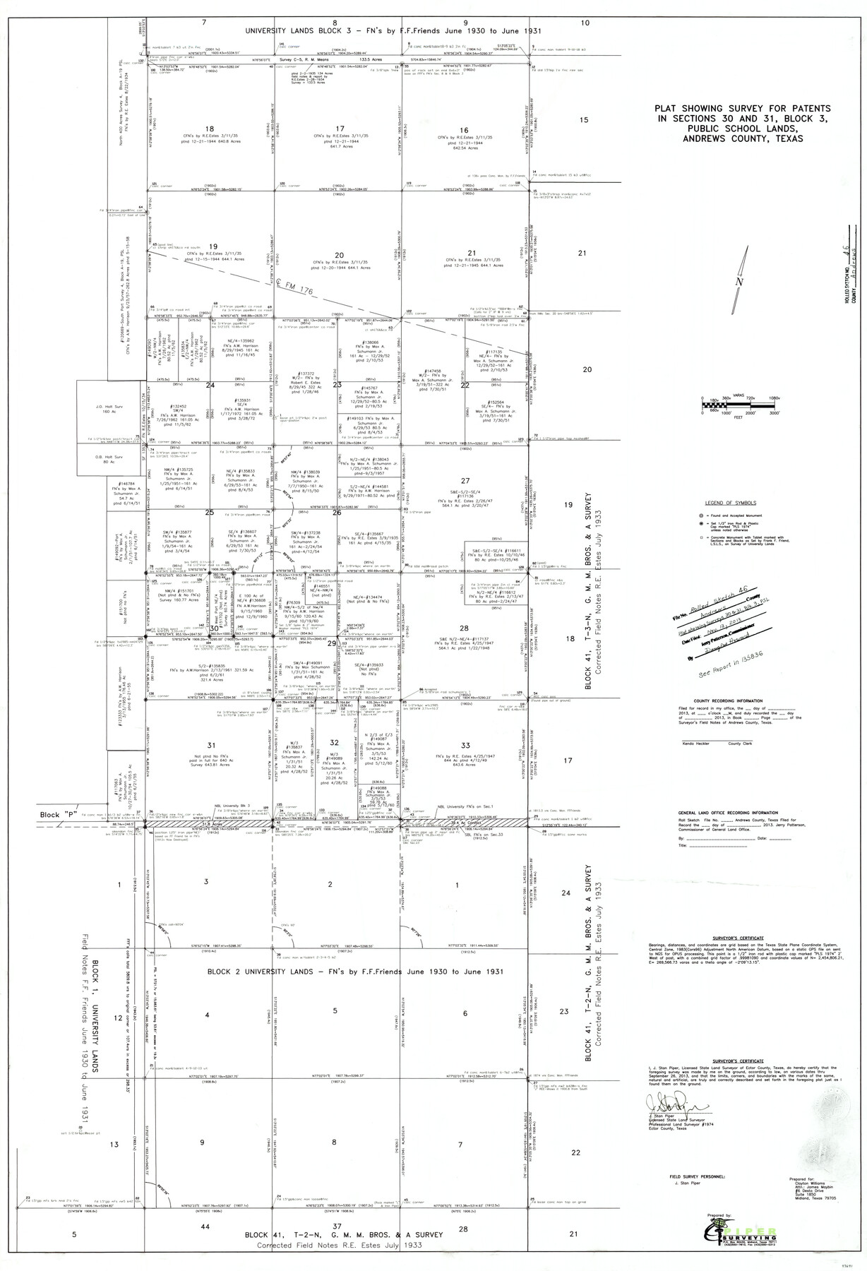
Andrews County Rolled Sketch 46
Plat showing survey for patents in sections 30 and 31, Block 3, Public School Lands, Andrews County, Texas
- 
                          Map/Doc93641
- 
                            CollectionGeneral Map Collection
- 
                            Object Dates9/26/2013 (Creation Date)11/13/2013 (File Date)
- 
                            People and OrganizationsJ. Stan Piper (Surveyor/Engineer)
- 
                            CountiesAndrews
- 
                            SubjectsSurveying Rolled Sketch
- 
                            Height x Width52.0 x 36.0 inches132.1 x 91.4 cm
- 
                            Mediummylar, print
- 
                            Scale1" = 360 varas
- 
                            CommentsSee surveyor's repot in School File 135836.
Part of: General Map Collection
            Cooke County Sketch File 3


                                            Print $2.00                    
                                             -                         Digital $50.00                                    
                Cooke County Sketch File 3
1873
Size 6.3 x 7.7 inches
                                Map/Doc 19222
            
            Cochran County Rolled Sketch 5


                                            Print $20.00                    
                                             -                         Digital $50.00                                    
                Cochran County Rolled Sketch 5
1949
Size 21.5 x 22.0 inches
                                Map/Doc 5502
            
            Brewster County Rolled Sketch 114


                                            Print $20.00                    
                                             -                         Digital $50.00                                    
                Brewster County Rolled Sketch 114
1964
Size 12.0 x 17.5 inches
                                Map/Doc 5291
            
            [Portion of Panola Judicial District]
            
                                    ![78365, [Portion of Panola Judicial District], General Map Collection](https://historictexasmaps.com/wmedia_w700/maps/78365.tif.jpg) 


    ![78365, [Portion of Panola Judicial District], General Map Collection](https://historictexasmaps.com/wmedia_w700/maps/78365.tif.jpg) 
                                
            
                                            Print $3.00                    
                                             -                         Digital $50.00                                    
                [Portion of Panola Judicial District]
1841
Size 17.1 x 10.0 inches
                                Map/Doc 78365
            
            [Sketch for Mineral Application 26542 - Sabine River between Prairie and Hawkins Creek, F. B. Jackson, Jr.]
            
                                    ![65670, [Sketch for Mineral Application 26542 - Sabine River between Prairie and Hawkins Creek, F. B. Jackson, Jr.], General Map Collection](https://historictexasmaps.com/wmedia_w700/maps/65670.tif.jpg) 


    ![65670, [Sketch for Mineral Application 26542 - Sabine River between Prairie and Hawkins Creek, F. B. Jackson, Jr.], General Map Collection](https://historictexasmaps.com/wmedia_w700/maps/65670.tif.jpg) 
                                
            
                                            Print $40.00                    
                                             -                         Digital $50.00                                    
                [Sketch for Mineral Application 26542 - Sabine River between Prairie and Hawkins Creek, F. B. Jackson, Jr.]
1931
Size 64.4 x 21.0 inches
                                Map/Doc 65670
            
            Nueces County Sketch File 25


                                            Print $14.00                    
                                             -                         Digital $50.00                                    
                Nueces County Sketch File 25
1876
Size 8.7 x 6.3 inches
                                Map/Doc 32572
            
            Flight Mission No. DAG-24K, Frame 138, Matagorda County


                                            Print $20.00                    
                                             -                         Digital $50.00                                    
                Flight Mission No. DAG-24K, Frame 138, Matagorda County
1953
Size 18.4 x 15.8 inches
                                Map/Doc 86556
            
            Mills County Rolled Sketch 1


                                            Print $20.00                    
                                             -                         Digital $50.00                                    
                Mills County Rolled Sketch 1
Size 29.6 x 30.4 inches
                                Map/Doc 6779
            
            Geographical, Statistical, and Historical Map of Arkansas Territory


                                            Print $20.00                    
                                             -                         Digital $50.00                                    
                Geographical, Statistical, and Historical Map of Arkansas Territory
Size 17.9 x 21.9 inches
                                Map/Doc 95713
            
            [Surveys along the Trinity River]
            
                                    ![330, [Surveys along the Trinity River], General Map Collection](https://historictexasmaps.com/wmedia_w700/maps/330.tif.jpg) 


    ![330, [Surveys along the Trinity River], General Map Collection](https://historictexasmaps.com/wmedia_w700/maps/330.tif.jpg) 
                                
            
                                            Print $2.00                    
                                             -                         Digital $50.00                                    
                [Surveys along the Trinity River]
1846
Size 9.0 x 12.2 inches
                                Map/Doc 330
            
            Howard County Sketch File 4


                                            Print $20.00                    
                                             -                         Digital $50.00                                    
                Howard County Sketch File 4
Size 25.6 x 21.8 inches
                                Map/Doc 11793
            
            Victoria County Rolled Sketch 9


                                            Print $20.00                    
                                             -                         Digital $50.00                                    
                Victoria County Rolled Sketch 9
Size 24.1 x 36.1 inches
                                Map/Doc 95400
            You may also like
            Cameron County Aerial Photograph Index Sheet 6


                                            Print $20.00                    
                                             -                         Digital $50.00                                    
                Cameron County Aerial Photograph Index Sheet 6
1955
Size 20.6 x 14.0 inches
                                Map/Doc 83678
            
            Sutton County


                                            Print $40.00                    
                                             -                         Digital $50.00                                    
                Sutton County
1941
Size 43.8 x 56.5 inches
                                Map/Doc 95647
            
            La Salle County Boundary File 57a


                                            Print $6.00                    
                                             -                         Digital $50.00                                    
                La Salle County Boundary File 57a
Size 14.3 x 8.8 inches
                                Map/Doc 56255
            
            Panola County Working Sketch 10


                                            Print $20.00                    
                                             -                         Digital $50.00                                    
                Panola County Working Sketch 10
1943
Map/Doc 71419
            
            Harris County Sketch File G


                                            Print $4.00                    
                                             -                         Digital $50.00                                    
                Harris County Sketch File G
1860
Size 6.6 x 7.3 inches
                                Map/Doc 25319
            
            Jeff Davis County Rolled Sketch 38


                                            Print $20.00                    
                                             -                         Digital $50.00                                    
                Jeff Davis County Rolled Sketch 38
1994
Size 26.1 x 35.1 inches
                                Map/Doc 6381
            
            Flight Mission No. CRE-3R, Frame 38, Jackson County


                                            Print $20.00                    
                                             -                         Digital $50.00                                    
                Flight Mission No. CRE-3R, Frame 38, Jackson County
1956
Size 18.6 x 22.2 inches
                                Map/Doc 85384
            
            Republic-Era Colonies. 1841-1844


                                            Print $20.00                    
                                    
                Republic-Era Colonies. 1841-1844
2020
Size 22.7 x 21.7 inches
                                Map/Doc 96372
            
            Current Miscellaneous File 57


                                            Print $4.00                    
                                             -                         Digital $50.00                                    
                Current Miscellaneous File 57
1955
Size 11.8 x 9.2 inches
                                Map/Doc 74050
            
            Principal Highways of the Southwest with particular reference to New Mexico, Oklahoma, Texas, Arkansas and Louisiana


                                            Print $20.00                    
                                    
                Principal Highways of the Southwest with particular reference to New Mexico, Oklahoma, Texas, Arkansas and Louisiana
1933
Size 24.3 x 18.4 inches
                                Map/Doc 76302
            
            Red River County Working Sketch 27


                                            Print $20.00                    
                                             -                         Digital $50.00                                    
                Red River County Working Sketch 27
1961
Size 25.3 x 42.7 inches
                                Map/Doc 72010
            
            Map of the Fort Worth & Denver City Railway


                                            Print $40.00                    
                                             -                         Digital $50.00                                    
                Map of the Fort Worth & Denver City Railway
1887
Size 22.2 x 79.5 inches
                                Map/Doc 64459
            