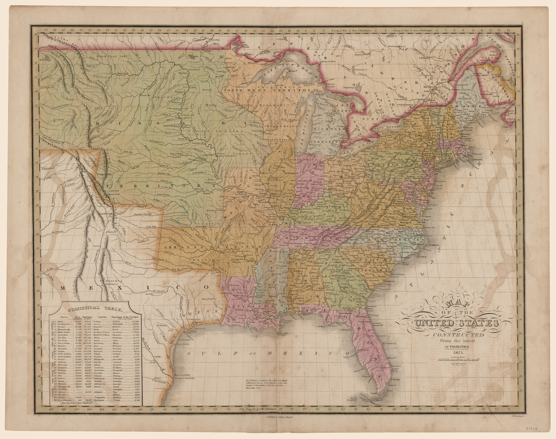
Map of the United States constructed from the latest authorities
-
Map/Doc
93924
-
Collection
General Map Collection
-
Object Dates
1825 (Creation Date)
2015/7/24 (File Date)
-
People and Organizations
A. Finley (Publisher)
-
Subjects
United States
-
Height x Width
19.4 x 24.5 inches
49.3 x 62.2 cm
-
Medium
paper, etching/engraving/lithograph
Part of: General Map Collection
Collingsworth County Rolled Sketch 2A

Print $20.00
- Digital $50.00
Collingsworth County Rolled Sketch 2A
1888
Size 15.3 x 45.8 inches
Map/Doc 8638
Flight Mission No. BRA-3M, Frame 125, Jefferson County

Print $20.00
- Digital $50.00
Flight Mission No. BRA-3M, Frame 125, Jefferson County
1953
Size 18.6 x 21.5 inches
Map/Doc 85399
Val Verde County Working Sketch 99

Print $20.00
- Digital $50.00
Val Verde County Working Sketch 99
1981
Size 17.2 x 22.6 inches
Map/Doc 72234
Flight Mission No. CRC-3R, Frame 55, Chambers County

Print $20.00
- Digital $50.00
Flight Mission No. CRC-3R, Frame 55, Chambers County
1956
Size 18.6 x 22.4 inches
Map/Doc 84827

Jasper County Working Sketch 28

Print $20.00
- Digital $50.00
Jasper County Working Sketch 28
1955
Size 22.6 x 15.6 inches
Map/Doc 66490

Presidio County Working Sketch 117

Print $20.00
- Digital $50.00
Presidio County Working Sketch 117
1982
Size 14.7 x 15.9 inches
Map/Doc 71794
Brazoria County Rolled Sketch 49

Print $20.00
- Digital $50.00
Brazoria County Rolled Sketch 49
1948
Size 24.1 x 36.5 inches
Map/Doc 5186
Flight Mission No. BRA-16M, Frame 73, Jefferson County

Print $20.00
- Digital $50.00
Flight Mission No. BRA-16M, Frame 73, Jefferson County
1953
Size 18.7 x 22.3 inches
Map/Doc 85690
Flight Mission No. BRA-16M, Frame 132, Jefferson County

Print $20.00
- Digital $50.00
Flight Mission No. BRA-16M, Frame 132, Jefferson County
1953
Size 18.6 x 22.3 inches
Map/Doc 85742
Wilson County

Print $20.00
- Digital $50.00
Wilson County
1921
Size 38.9 x 46.2 inches
Map/Doc 77461
You may also like
Newton County Working Sketch 32

Print $20.00
- Digital $50.00
Newton County Working Sketch 32
1955
Size 22.9 x 24.0 inches
Map/Doc 71278
Nueces County NRC Article 33.136 Location Key Sheet

Print $20.00
- Digital $50.00
Nueces County NRC Article 33.136 Location Key Sheet
1975
Size 27.0 x 23.0 inches
Map/Doc 77032
Flight Mission No. DQN-1K, Frame 129, Calhoun County

Print $20.00
- Digital $50.00
Flight Mission No. DQN-1K, Frame 129, Calhoun County
1953
Size 18.5 x 22.2 inches
Map/Doc 84192
Hansford County Sketch File 3

Print $20.00
- Digital $50.00
Hansford County Sketch File 3
Size 18.6 x 23.1 inches
Map/Doc 11620
Perspective Map of Texarkana, Texas and Arkansas

Print $20.00
Perspective Map of Texarkana, Texas and Arkansas
1888
Size 18.1 x 29.2 inches
Map/Doc 93485
Map of The Surveyed Part of Peters Colony Texas

Print $40.00
- Digital $50.00
Map of The Surveyed Part of Peters Colony Texas
1852
Size 56.5 x 41.0 inches
Map/Doc 1966
Bird's Eye View of Victoria

Print $20.00
Bird's Eye View of Victoria
1873
Size 24.6 x 28.9 inches
Map/Doc 89210

Henderson County Working Sketch 42

Print $20.00
- Digital $50.00
Henderson County Working Sketch 42
1990
Size 23.5 x 24.6 inches
Map/Doc 66175
Wilbarger County Working Sketch 16

Print $20.00
- Digital $50.00
Wilbarger County Working Sketch 16
1955
Size 32.7 x 19.9 inches
Map/Doc 72554
Haskell County Rolled Sketch 5

Print $20.00
- Digital $50.00
Haskell County Rolled Sketch 5
1858
Size 30.0 x 39.0 inches
Map/Doc 6165
Milam County Working Sketch 9

Print $20.00
- Digital $50.00
Milam County Working Sketch 9
1976
Size 27.2 x 22.7 inches
Map/Doc 71024