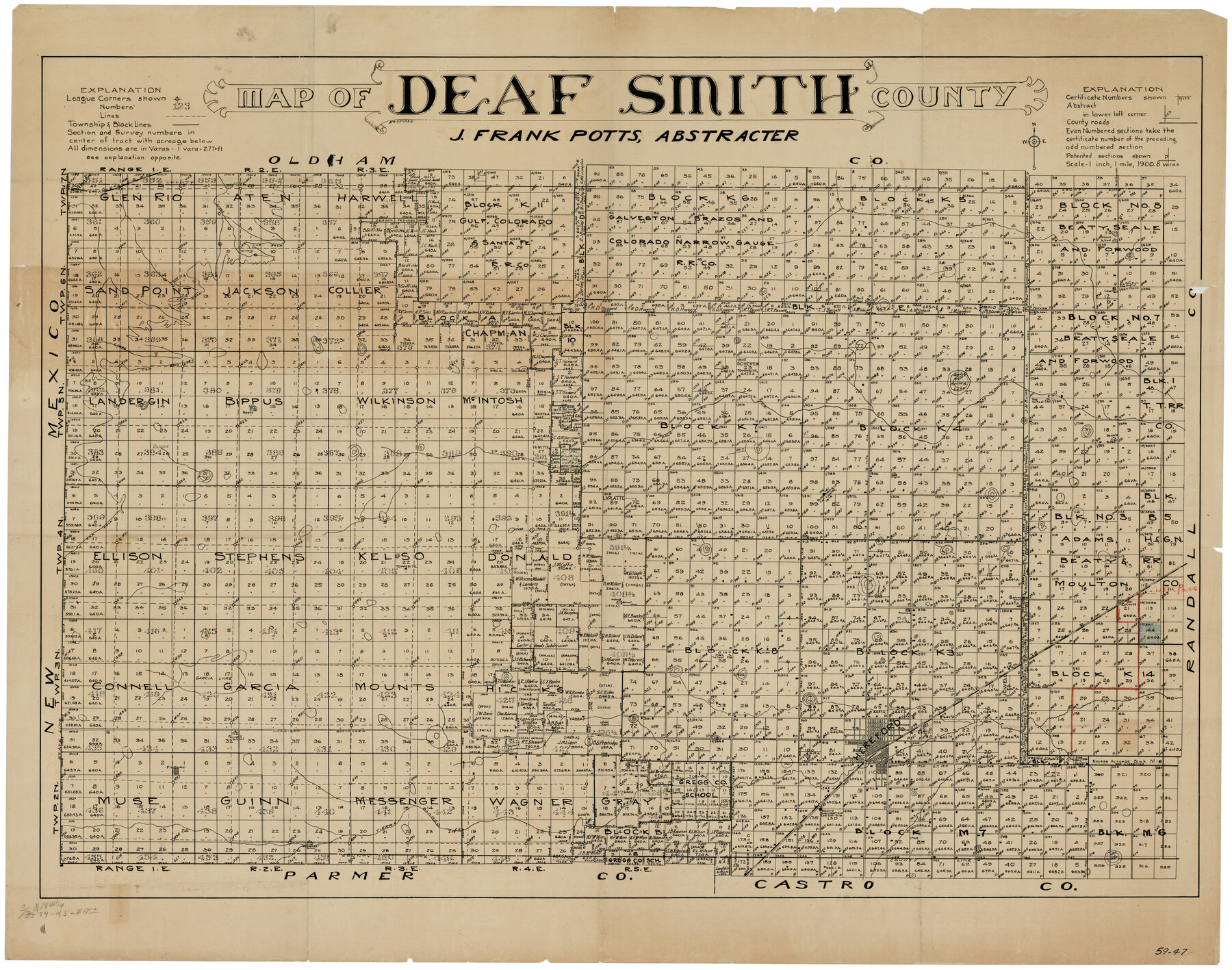
Deaf Smith County
59-47
-
Map/Doc
89768
-
Collection
Twichell Survey Records
-
Object Dates
4/25/1922 (Creation Date)
-
People and Organizations
J. Frank Potts (Draftsman)
-
Counties
Deaf Smith
-
Subjects
County
-
Height x Width
55.0 x 43.9 inches
139.7 x 111.5 cm
Part of: Twichell Survey Records
Map Showing Blocks 15, 16 & 18 S.P.R.R.Co.

Print $20.00
- Digital $50.00
Map Showing Blocks 15, 16 & 18 S.P.R.R.Co.
1933
Size 24.7 x 19.1 inches
Map/Doc 92282
Map of Partition Subdivision of A.B. Robertson's Ranch in Crosby and Garza Counties, Texas 1926

Print $20.00
- Digital $50.00
Map of Partition Subdivision of A.B. Robertson's Ranch in Crosby and Garza Counties, Texas 1926
1926
Size 39.1 x 42.7 inches
Map/Doc 89755
[Sketch of Blocks M-19, 21W, JAD, 9 and G. & M. Block 5]
![91736, [Sketch of Blocks M-19, 21W, JAD, 9 and G. & M. Block 5], Twichell Survey Records](https://historictexasmaps.com/wmedia_w700/maps/91736-1.tif.jpg)
Print $20.00
- Digital $50.00
[Sketch of Blocks M-19, 21W, JAD, 9 and G. & M. Block 5]
Size 34.0 x 25.9 inches
Map/Doc 91736
Borden County

Print $20.00
- Digital $50.00
Borden County
1922
Size 36.8 x 41.7 inches
Map/Doc 92457
[USGS Topo Quad map of Shafter Sheet, Presidio County]
![91754, [USGS Topo Quad map of Shafter Sheet, Presidio County], Twichell Survey Records](https://historictexasmaps.com/wmedia_w700/maps/91754-1.tif.jpg)
Print $20.00
- Digital $50.00
[USGS Topo Quad map of Shafter Sheet, Presidio County]
1895
Size 16.9 x 20.5 inches
Map/Doc 91754
[Capitol Leagues 217-228, 238, and vicinity]
![90695, [Capitol Leagues 217-228, 238, and vicinity], Twichell Survey Records](https://historictexasmaps.com/wmedia_w700/maps/90695-1.tif.jpg)
Print $20.00
- Digital $50.00
[Capitol Leagues 217-228, 238, and vicinity]
Size 23.8 x 12.9 inches
Map/Doc 90695
[G. C. & S. F. Railroad Company Block H2, Town of Adrian, and Vicinity]
![91439, [G. C. & S. F. Railroad Company Block H2, Town of Adrian, and Vicinity], Twichell Survey Records](https://historictexasmaps.com/wmedia_w700/maps/91439-1.tif.jpg)
Print $20.00
- Digital $50.00
[G. C. & S. F. Railroad Company Block H2, Town of Adrian, and Vicinity]
Size 24.4 x 15.8 inches
Map/Doc 91439
[Portion of Blocks C and C2]
![90696, [Portion of Blocks C and C2], Twichell Survey Records](https://historictexasmaps.com/wmedia_w700/maps/90696-1.tif.jpg)
Print $20.00
- Digital $50.00
[Portion of Blocks C and C2]
1906
Size 24.4 x 12.4 inches
Map/Doc 90696
[Sketch showing T. & N. O. Blocks 3T and 6T, Denison and Pacific RR. Co. Block O-18 and surrounding areas]
![93001, [Sketch showing T. & N. O. Blocks 3T and 6T, Denison and Pacific RR. Co. Block O-18 and surrounding areas], Twichell Survey Records](https://historictexasmaps.com/wmedia_w700/maps/93001-1.tif.jpg)
Print $20.00
- Digital $50.00
[Sketch showing T. & N. O. Blocks 3T and 6T, Denison and Pacific RR. Co. Block O-18 and surrounding areas]
Size 21.0 x 28.5 inches
Map/Doc 93001
[Leagues 7, 8, 9, and 10]
![92220, [Leagues 7, 8, 9, and 10], Twichell Survey Records](https://historictexasmaps.com/wmedia_w700/maps/92220-1.tif.jpg)
Print $20.00
- Digital $50.00
[Leagues 7, 8, 9, and 10]
1943
Size 18.3 x 12.2 inches
Map/Doc 92220
Plat showing proposed Water Permit on Cow Bayou in Orange County, Texas

Print $20.00
- Digital $50.00
Plat showing proposed Water Permit on Cow Bayou in Orange County, Texas
1922
Size 24.3 x 16.4 inches
Map/Doc 93017
[PSL Block B-19]
![93127, [PSL Block B-19], Twichell Survey Records](https://historictexasmaps.com/wmedia_w700/maps/93127-1.tif.jpg)
Print $40.00
- Digital $50.00
[PSL Block B-19]
Size 49.1 x 45.5 inches
Map/Doc 93127
You may also like
General Highway Map, Stonewall County, Texas

Print $20.00
General Highway Map, Stonewall County, Texas
1961
Size 18.3 x 25.1 inches
Map/Doc 79662
Young County Working Sketch 1

Print $20.00
- Digital $50.00
Young County Working Sketch 1
1960
Size 31.1 x 41.9 inches
Map/Doc 62024
Flight Mission No. CRC-5R, Frame 24, Chambers County

Print $20.00
- Digital $50.00
Flight Mission No. CRC-5R, Frame 24, Chambers County
1956
Size 18.7 x 22.4 inches
Map/Doc 84946
Culberson County Working Sketch 15

Print $20.00
- Digital $50.00
Culberson County Working Sketch 15
1923
Size 19.9 x 21.5 inches
Map/Doc 68467
Refugio County Boundary File 74

Print $172.00
- Digital $50.00
Refugio County Boundary File 74
Size 9.3 x 4.4 inches
Map/Doc 58272
Rockwall County Boundary File 3a

Print $6.00
- Digital $50.00
Rockwall County Boundary File 3a
Size 6.2 x 8.7 inches
Map/Doc 58393
Reagan County Working Sketch 6

Print $20.00
- Digital $50.00
Reagan County Working Sketch 6
1924
Size 27.3 x 17.7 inches
Map/Doc 71846
Rankin County Seat Showing East Rankin

Print $20.00
- Digital $50.00
Rankin County Seat Showing East Rankin
Size 31.2 x 34.5 inches
Map/Doc 92852
Brewster County Sketch File S-17

Print $30.00
- Digital $50.00
Brewster County Sketch File S-17
1939
Size 11.3 x 8.8 inches
Map/Doc 15799
Sutton County Sketch File 54

Print $6.00
- Digital $50.00
Sutton County Sketch File 54
1948
Size 10.8 x 11.5 inches
Map/Doc 37534
Pecos County Working Sketch 117

Print $40.00
- Digital $50.00
Pecos County Working Sketch 117
1973
Size 57.7 x 36.8 inches
Map/Doc 71590
Runnels County Sketch File 11

Print $8.00
Runnels County Sketch File 11
1883
Size 10.7 x 7.9 inches
Map/Doc 35452