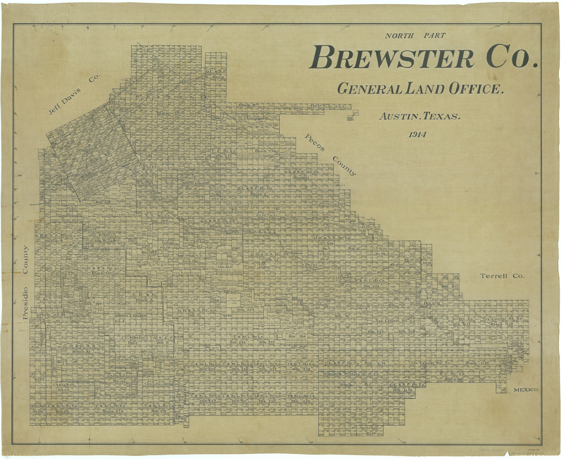
North Part Brewster Co.
-
Map/Doc
66732
-
Collection
General Map Collection
-
Object Dates
1914 (Creation Date)
-
People and Organizations
Texas General Land Office (Publisher)
-
Counties
Brewster
-
Subjects
County
-
Height x Width
40.4 x 49.3 inches
102.6 x 125.2 cm
Part of: General Map Collection
Pecos County Sketch File 24

Print $22.00
- Digital $50.00
Pecos County Sketch File 24
Size 7.6 x 5.6 inches
Map/Doc 33680
Parker County Boundary File 1

Print $6.00
- Digital $50.00
Parker County Boundary File 1
Size 11.2 x 8.7 inches
Map/Doc 57833
Galveston County NRC Article 33.136 Sketch 74

Print $26.00
- Digital $50.00
Galveston County NRC Article 33.136 Sketch 74
2013
Size 24.0 x 36.0 inches
Map/Doc 95114
Rockwall County Sketch File 3

Print $6.00
Rockwall County Sketch File 3
1851
Size 17.2 x 11.6 inches
Map/Doc 35417
Galveston County Sketch File 73

Print $78.00
- Digital $50.00
Galveston County Sketch File 73
1998
Size 11.3 x 8.8 inches
Map/Doc 23980
Bandera County Sketch File 29

Print $40.00
- Digital $50.00
Bandera County Sketch File 29
1939
Size 17.3 x 17.4 inches
Map/Doc 10898
[Sketch for Mineral Application 16696-16697, Pecos River]
![76024, [Sketch for Mineral Application 16696-16697, Pecos River], General Map Collection](https://historictexasmaps.com/wmedia_w700/maps/76024.tif.jpg)
Print $40.00
- Digital $50.00
[Sketch for Mineral Application 16696-16697, Pecos River]
Size 44.0 x 126.6 inches
Map/Doc 76024
Flight Mission No. DQN-1K, Frame 68, Calhoun County

Print $20.00
- Digital $50.00
Flight Mission No. DQN-1K, Frame 68, Calhoun County
1953
Size 18.6 x 22.2 inches
Map/Doc 84155
Medina County Working Sketch 6

Print $20.00
- Digital $50.00
Medina County Working Sketch 6
1950
Size 20.7 x 21.3 inches
Map/Doc 70921
Cooke County Sketch File 20

Print $22.00
- Digital $50.00
Cooke County Sketch File 20
1862
Size 9.1 x 6.9 inches
Map/Doc 19264
Flight Mission No. CGI-3N, Frame 126, Cameron County

Print $20.00
- Digital $50.00
Flight Mission No. CGI-3N, Frame 126, Cameron County
1954
Size 18.5 x 22.1 inches
Map/Doc 84599
Trace of a copy of the map captured at the battle of Resaca de la Palma

Print $20.00
- Digital $50.00
Trace of a copy of the map captured at the battle of Resaca de la Palma
Size 18.3 x 27.3 inches
Map/Doc 73054
You may also like
Nueces County Rolled Sketch 63

Print $20.00
- Digital $50.00
Nueces County Rolled Sketch 63
1979
Size 25.5 x 38.1 inches
Map/Doc 6909

Galveston County Sketch File 55

Print $20.00
- Digital $50.00
Galveston County Sketch File 55
1839
Size 5.2 x 3.7 inches
Map/Doc 23591
Mason County Rolled Sketch 8

Print $20.00
- Digital $50.00
Mason County Rolled Sketch 8
2010
Size 18.5 x 24.4 inches
Map/Doc 89283
Burnet County Sketch File 41

Print $8.00
- Digital $50.00
Burnet County Sketch File 41
1950
Size 11.8 x 8.6 inches
Map/Doc 16757
Fannin County Boundary File 10a and 10b and 10c

Print $4.00
- Digital $50.00
Fannin County Boundary File 10a and 10b and 10c
Size 11.3 x 8.8 inches
Map/Doc 53325
Briscoe County Rolled Sketch 18

Print $20.00
- Digital $50.00
Briscoe County Rolled Sketch 18
1946
Size 36.7 x 27.3 inches
Map/Doc 5332
Anderson County Sketch File 7

Print $4.00
- Digital $50.00
Anderson County Sketch File 7
Size 7.9 x 10.0 inches
Map/Doc 12757
National Railways of Mexico

Digital $50.00
National Railways of Mexico
1966
Size 8.9 x 17.6 inches
Map/Doc 94189
Matagorda County Working Sketch 13

Print $20.00
- Digital $50.00
Matagorda County Working Sketch 13
1949
Size 41.5 x 35.7 inches
Map/Doc 70871
Coryell County Working Sketch 21

Print $20.00
- Digital $50.00
Coryell County Working Sketch 21
1973
Size 37.0 x 37.8 inches
Map/Doc 68228
Borden County Sketch File 12

Print $24.00
- Digital $50.00
Borden County Sketch File 12
Size 10.8 x 9.1 inches
Map/Doc 14732