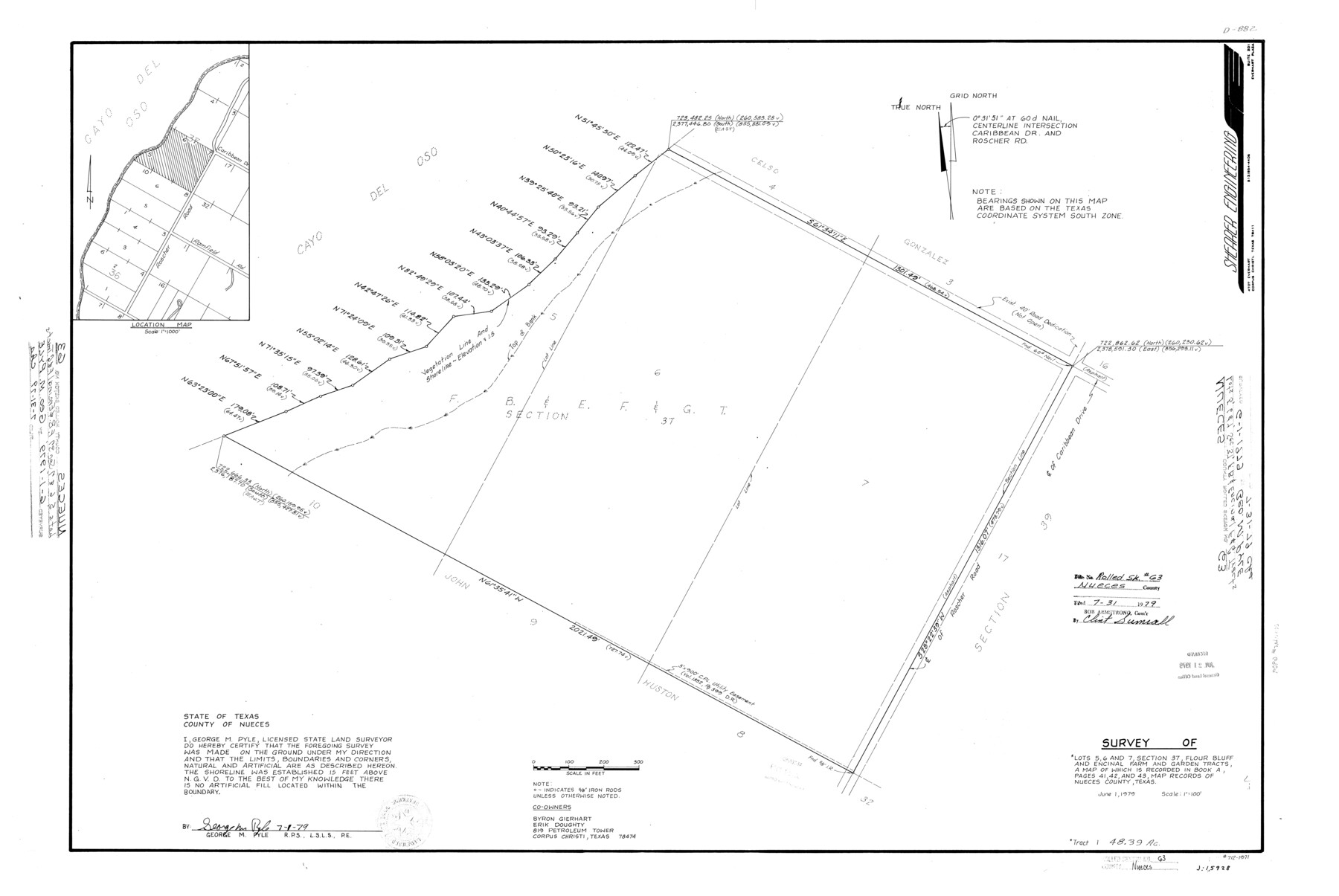
Nueces County Rolled Sketch 63
Survey of lots 5, 6, and 7, section 37, Flour Bluff and Encinal Farm and Garden Tracts
-
Map/Doc
6909
-
Collection
General Map Collection
-
Object Dates
1979/7/1 (Creation Date)
1979/7/31 (File Date)
-
People and Organizations
George M. Pyle (Surveyor/Engineer)
-
Counties
Nueces
-
Subjects
Cadastral Surveying Rolled Sketch
-
Height x Width
25.5 x 38.1 inches
64.8 x 96.8 cm
-
Medium
mylar, print
-
Scale
1" = 100 feet
-
Comments
See Nueces County Sketch File 64 (32975) for report.
Related maps
Nueces County Sketch File 64
![32975, Nueces County Sketch File 64, General Map Collection](https://historictexasmaps.com/wmedia_w700/pdf_converted_jpg/qi_pdf_thumbnail_13385.jpg)
Print $10.00
- Digital $50.00
Nueces County Sketch File 64
1979
Size 11.2 x 8.6 inches
Map/Doc 32975
Part of: General Map Collection
Flight Mission No. DCL-7C, Frame 54, Kenedy County
![86042, Flight Mission No. DCL-7C, Frame 54, Kenedy County, General Map Collection](https://historictexasmaps.com/wmedia_w700/pdf_converted_jpg/qi_pdf_thumbnail_33188.jpg)
Print $20.00
- Digital $50.00
Flight Mission No. DCL-7C, Frame 54, Kenedy County
1943
Size 15.3 x 15.3 inches
Map/Doc 86042
Tarrant County Sketch File 1a
![37670, Tarrant County Sketch File 1a, General Map Collection](https://historictexasmaps.com/wmedia_w700/pdf_converted_jpg/qi_pdf_thumbnail_14408.jpg)
Print $4.00
- Digital $50.00
Tarrant County Sketch File 1a
1851
Size 10.2 x 7.8 inches
Map/Doc 37670
Flight Mission No. BRE-3P, Frame 96, Nueces County
![86827, Flight Mission No. BRE-3P, Frame 96, Nueces County, General Map Collection](https://historictexasmaps.com/wmedia_w700/pdf_converted_jpg/qi_pdf_thumbnail_33964.jpg)
Print $20.00
- Digital $50.00
Flight Mission No. BRE-3P, Frame 96, Nueces County
1956
Size 18.3 x 22.2 inches
Map/Doc 86827
Map of Hill County
![82049, Map of Hill County, General Map Collection](https://historictexasmaps.com/wmedia_w700/maps/82049-1.tif.jpg)
Print $40.00
- Digital $50.00
Map of Hill County
1884
Size 80.1 x 68.0 inches
Map/Doc 82049
San Patricio County Rolled Sketch 20
![7577, San Patricio County Rolled Sketch 20, General Map Collection](https://historictexasmaps.com/wmedia_w700/maps/7577.tif.jpg)
Print $20.00
- Digital $50.00
San Patricio County Rolled Sketch 20
1920
Size 27.7 x 31.9 inches
Map/Doc 7577
Val Verde County Sketch File 46
![12587, Val Verde County Sketch File 46, General Map Collection](https://historictexasmaps.com/wmedia_w700/pdf_converted_jpg/qi_pdf_thumbnail_8860.jpg)
Print $20.00
- Digital $50.00
Val Verde County Sketch File 46
1951
Size 18.9 x 22.6 inches
Map/Doc 12587
Map of Terry County
![16893, Map of Terry County, General Map Collection](https://historictexasmaps.com/wmedia_w700/maps/16893.tif.jpg)
Print $20.00
- Digital $50.00
Map of Terry County
1902
Size 45.6 x 40.8 inches
Map/Doc 16893
Flight Mission No. BRE-3P, Frame 77, Nueces County
![86818, Flight Mission No. BRE-3P, Frame 77, Nueces County, General Map Collection](https://historictexasmaps.com/wmedia_w700/pdf_converted_jpg/qi_pdf_thumbnail_33955.jpg)
Print $20.00
- Digital $50.00
Flight Mission No. BRE-3P, Frame 77, Nueces County
1956
Size 18.6 x 22.6 inches
Map/Doc 86818
South Sulphur River, Klondike Sheet
![78332, South Sulphur River, Klondike Sheet, General Map Collection](https://historictexasmaps.com/wmedia_w700/maps/78332.tif.jpg)
Print $20.00
- Digital $50.00
South Sulphur River, Klondike Sheet
1925
Size 18.2 x 19.9 inches
Map/Doc 78332
Gaines County
![16833, Gaines County, General Map Collection](https://historictexasmaps.com/wmedia_w700/maps/16833.tif.jpg)
Print $40.00
- Digital $50.00
Gaines County
1901
Size 41.3 x 57.2 inches
Map/Doc 16833
You may also like
Fisher County Rolled Sketch 3
![8887, Fisher County Rolled Sketch 3, General Map Collection](https://historictexasmaps.com/wmedia_w700/maps/8887.tif.jpg)
Print $20.00
- Digital $50.00
Fisher County Rolled Sketch 3
Size 40.5 x 38.6 inches
Map/Doc 8887
Pecos County Working Sketch 45
![71517, Pecos County Working Sketch 45, General Map Collection](https://historictexasmaps.com/wmedia_w700/maps/71517.tif.jpg)
Print $20.00
- Digital $50.00
Pecos County Working Sketch 45
Size 20.8 x 26.7 inches
Map/Doc 71517
Flight Mission No. CLL-1N, Frame 40, Willacy County
![87021, Flight Mission No. CLL-1N, Frame 40, Willacy County, General Map Collection](https://historictexasmaps.com/wmedia_w700/pdf_converted_jpg/qi_pdf_thumbnail_34155.jpg)
Print $20.00
- Digital $50.00
Flight Mission No. CLL-1N, Frame 40, Willacy County
1954
Size 18.5 x 22.2 inches
Map/Doc 87021
Preliminary Chart of the Entrance to Matagorda Bay, Texas
![76247, Preliminary Chart of the Entrance to Matagorda Bay, Texas, Texas State Library and Archives](https://historictexasmaps.com/wmedia_w700/maps/76247.tif.jpg)
Print $20.00
Preliminary Chart of the Entrance to Matagorda Bay, Texas
1857
Size 20.2 x 32.9 inches
Map/Doc 76247
Castro County, Texas
![694, Castro County, Texas, Maddox Collection](https://historictexasmaps.com/wmedia_w700/maps/694.tif.jpg)
Print $20.00
- Digital $50.00
Castro County, Texas
1891
Size 24.5 x 20.4 inches
Map/Doc 694
Sketch of a portion of the Texas Coast showing the relative positions of different harbours with the interior Military Posts, and the roads communicating with them, also two new routes from Black Point and Lamar to San Antonio
![72711, Sketch of a portion of the Texas Coast showing the relative positions of different harbours with the interior Military Posts, and the roads communicating with them, also two new routes from Black Point and Lamar to San Antonio, General Map Collection](https://historictexasmaps.com/wmedia_w700/maps/72711.tif.jpg)
Print $20.00
- Digital $50.00
Sketch of a portion of the Texas Coast showing the relative positions of different harbours with the interior Military Posts, and the roads communicating with them, also two new routes from Black Point and Lamar to San Antonio
1855
Size 27.2 x 18.3 inches
Map/Doc 72711
The Republic County of Houston. February 2, 1842
![96181, The Republic County of Houston. February 2, 1842, Nancy and Jim Tiller Digital Collection](https://historictexasmaps.com/wmedia_w700/maps/96181.tif.jpg)
Print $20.00
- Digital $50.00
The Republic County of Houston. February 2, 1842
2020
Size 9.8 x 10.9 inches
Map/Doc 96181
Rockwall County Boundary File 9a
![58437, Rockwall County Boundary File 9a, General Map Collection](https://historictexasmaps.com/wmedia_w700/pdf_converted_jpg/qi_pdf_thumbnail_16757.jpg)
Print $4.00
- Digital $50.00
Rockwall County Boundary File 9a
Size 14.0 x 8.8 inches
Map/Doc 58437
Map of the Fort Worth & Denver City Railway, Hartley County, Texas
![64390, Map of the Fort Worth & Denver City Railway, Hartley County, Texas, General Map Collection](https://historictexasmaps.com/wmedia_w700/maps/64390.tif.jpg)
Print $40.00
- Digital $50.00
Map of the Fort Worth & Denver City Railway, Hartley County, Texas
1887
Size 21.9 x 89.8 inches
Map/Doc 64390
Grimes County Working Sketch 7
![63298, Grimes County Working Sketch 7, General Map Collection](https://historictexasmaps.com/wmedia_w700/maps/63298.tif.jpg)
Print $6.00
- Digital $50.00
Grimes County Working Sketch 7
Size 27.2 x 33.0 inches
Map/Doc 63298
Map showing the environs of Brazos Islnd. Texas
![72914, Map showing the environs of Brazos Islnd. Texas, General Map Collection](https://historictexasmaps.com/wmedia_w700/maps/72914.tif.jpg)
Print $20.00
- Digital $50.00
Map showing the environs of Brazos Islnd. Texas
1864
Size 26.2 x 18.2 inches
Map/Doc 72914
Right of Way and Track Map, Texas & New Orleans R.R. operated by the T. & N. O. R.R. Co., Rusk Branch
![64243, Right of Way and Track Map, Texas & New Orleans R.R. operated by the T. & N. O. R.R. Co., Rusk Branch, General Map Collection](https://historictexasmaps.com/wmedia_w700/maps/64243.tif.jpg)
Print $40.00
- Digital $50.00
Right of Way and Track Map, Texas & New Orleans R.R. operated by the T. & N. O. R.R. Co., Rusk Branch
1918
Size 24.7 x 56.2 inches
Map/Doc 64243