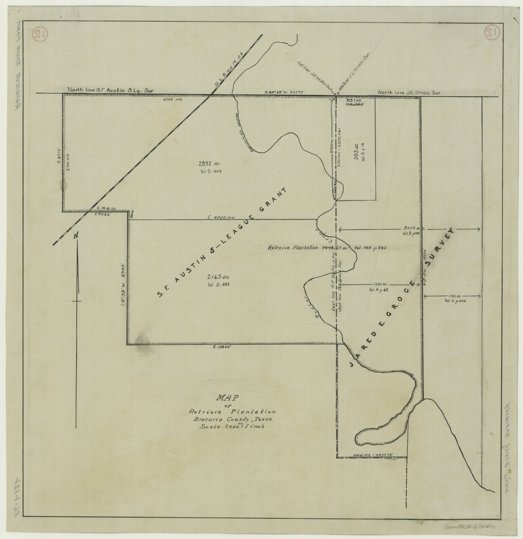
Map of Retrieve Plantation, Brazoria County, Texas
RG-1-12b
-
Map/Doc
63000
-
Collection
General Map Collection
-
Counties
Brazoria
-
Height x Width
16.9 x 16.4 inches
42.9 x 41.7 cm
Part of: General Map Collection
Nueces County Sketch File 76

Print $54.00
- Digital $50.00
Nueces County Sketch File 76
1992
Size 11.0 x 8.6 inches
Map/Doc 33032
Wichita County Rolled Sketch 14A

Print $40.00
- Digital $50.00
Wichita County Rolled Sketch 14A
Size 28.0 x 59.9 inches
Map/Doc 10138
Live Oak County Rolled Sketch 7

Print $20.00
- Digital $50.00
Live Oak County Rolled Sketch 7
1951
Size 31.3 x 36.9 inches
Map/Doc 6635
Presidio County Working Sketch 136

Print $20.00
- Digital $50.00
Presidio County Working Sketch 136
1990
Size 33.7 x 46.8 inches
Map/Doc 71814
[Pacific & Santa Fe Railroad through Fort Stockton]
![64770, [Pacific & Santa Fe Railroad through Fort Stockton], General Map Collection](https://historictexasmaps.com/wmedia_w700/maps/64770.tif.jpg)
Print $20.00
- Digital $50.00
[Pacific & Santa Fe Railroad through Fort Stockton]
Size 18.4 x 20.5 inches
Map/Doc 64770
Martin County Working Sketch 11

Print $40.00
- Digital $50.00
Martin County Working Sketch 11
1971
Size 49.8 x 38.1 inches
Map/Doc 70829
Wilson County Sketch File 1

Print $6.00
- Digital $50.00
Wilson County Sketch File 1
1858
Size 10.4 x 7.5 inches
Map/Doc 40396
Borden County Boundary File 4

Print $2.00
- Digital $50.00
Borden County Boundary File 4
Size 13.3 x 8.3 inches
Map/Doc 50636
Hutchinson County Working Sketch 38

Print $20.00
- Digital $50.00
Hutchinson County Working Sketch 38
1978
Size 27.2 x 22.5 inches
Map/Doc 66398
[Beaumont, Sour Lake and Western Ry. Right of Way and Alignment - Frisco]
![64120, [Beaumont, Sour Lake and Western Ry. Right of Way and Alignment - Frisco], General Map Collection](https://historictexasmaps.com/wmedia_w700/maps/64120.tif.jpg)
Print $20.00
- Digital $50.00
[Beaumont, Sour Lake and Western Ry. Right of Way and Alignment - Frisco]
1910
Size 19.7 x 45.6 inches
Map/Doc 64120
Val Verde County Rolled Sketch 60

Print $20.00
- Digital $50.00
Val Verde County Rolled Sketch 60
1951
Size 32.4 x 20.4 inches
Map/Doc 8127
Houston County Sketch File 29

Print $10.00
- Digital $50.00
Houston County Sketch File 29
1859
Size 15.0 x 9.4 inches
Map/Doc 26802
You may also like
Flight Mission No. DCL-7C, Frame 135, Kenedy County

Print $20.00
- Digital $50.00
Flight Mission No. DCL-7C, Frame 135, Kenedy County
1943
Size 15.5 x 15.3 inches
Map/Doc 86092
Duval County Working Sketch 46

Print $20.00
- Digital $50.00
Duval County Working Sketch 46
1980
Size 29.4 x 27.2 inches
Map/Doc 68770
Flight Mission No. CGI-3N, Frame 122, Cameron County

Print $20.00
- Digital $50.00
Flight Mission No. CGI-3N, Frame 122, Cameron County
1954
Size 18.6 x 22.2 inches
Map/Doc 84595
Fort Bend County Boundary File 2a

Print $42.00
- Digital $50.00
Fort Bend County Boundary File 2a
Size 23.7 x 34.3 inches
Map/Doc 53563
Morris County Working Sketch 3

Print $20.00
- Digital $50.00
Morris County Working Sketch 3
1958
Size 27.6 x 38.2 inches
Map/Doc 71202
Galveston County Rolled Sketch 40A

Print $20.00
- Digital $50.00
Galveston County Rolled Sketch 40A
1988
Size 42.0 x 46.0 inches
Map/Doc 9020
Flight Mission No. BRA-16M, Frame 149, Jefferson County

Print $20.00
- Digital $50.00
Flight Mission No. BRA-16M, Frame 149, Jefferson County
1953
Size 18.6 x 22.3 inches
Map/Doc 85755
San Augustine County Rolled Sketch 2

Print $20.00
- Digital $50.00
San Augustine County Rolled Sketch 2
1947
Size 29.1 x 23.1 inches
Map/Doc 7554
Runnels County Sketch File 5a

Print $40.00
Runnels County Sketch File 5a
1883
Size 8.9 x 22.0 inches
Map/Doc 35438
Presidio County Rolled Sketch 95

Print $20.00
- Digital $50.00
Presidio County Rolled Sketch 95
1949
Size 45.4 x 37.5 inches
Map/Doc 9781
Sutton County

Print $40.00
- Digital $50.00
Sutton County
1898
Size 41.1 x 58.3 inches
Map/Doc 78392
Childress County Sketch File 12

Print $22.00
- Digital $50.00
Childress County Sketch File 12
Size 13.3 x 8.7 inches
Map/Doc 18255