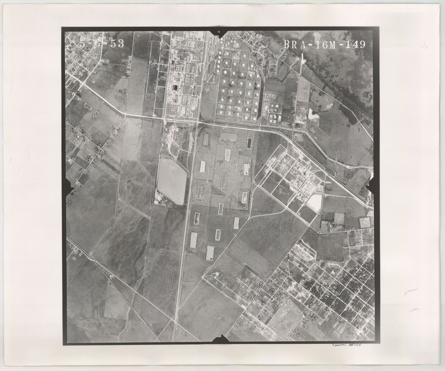
Flight Mission No. BRA-16M, Frame 149, Jefferson County
BRA-16M-149
-
Map/Doc
85755
-
Collection
General Map Collection
-
Object Dates
1953/5/6 (Creation Date)
-
People and Organizations
U. S. Department of Agriculture (Publisher)
-
Counties
Jefferson
-
Subjects
Aerial Photograph
-
Height x Width
18.6 x 22.3 inches
47.2 x 56.6 cm
-
Comments
Flown by Jack Ammann Photogrammetric Engineers of San Antonio, Texas.
Part of: General Map Collection
Flight Mission No. CRC-4R, Frame 163, Chambers County

Print $20.00
- Digital $50.00
Flight Mission No. CRC-4R, Frame 163, Chambers County
1956
Size 18.5 x 22.4 inches
Map/Doc 84922
Harris County Working Sketch 65

Print $20.00
- Digital $50.00
Harris County Working Sketch 65
1955
Size 29.5 x 28.6 inches
Map/Doc 65957
Copy of Surveyor's Field Book, Morris Browning - In Blocks 7, 5 & 4, I&GNRRCo., Hutchinson and Carson Counties, Texas

Print $2.00
- Digital $50.00
Copy of Surveyor's Field Book, Morris Browning - In Blocks 7, 5 & 4, I&GNRRCo., Hutchinson and Carson Counties, Texas
1888
Size 7.0 x 8.8 inches
Map/Doc 62278
Briscoe County

Print $20.00
- Digital $50.00
Briscoe County
1930
Size 42.3 x 35.8 inches
Map/Doc 95439
San Patricio County Rolled Sketch 35

Print $20.00
- Digital $50.00
San Patricio County Rolled Sketch 35
1958
Size 26.6 x 26.9 inches
Map/Doc 7586
Edwards County Working Sketch 28

Print $20.00
- Digital $50.00
Edwards County Working Sketch 28
1946
Size 30.0 x 33.5 inches
Map/Doc 68904
Jeff Davis County Sketch File 17

Print $6.00
- Digital $50.00
Jeff Davis County Sketch File 17
1884
Size 8.8 x 7.3 inches
Map/Doc 27948
Flight Mission No. CRC-4R, Frame 151, Chambers County

Print $20.00
- Digital $50.00
Flight Mission No. CRC-4R, Frame 151, Chambers County
1956
Size 18.8 x 22.4 inches
Map/Doc 84914
Trinity River, Walker's Lake Sheet/Richland Creek

Print $20.00
- Digital $50.00
Trinity River, Walker's Lake Sheet/Richland Creek
1931
Size 25.9 x 41.2 inches
Map/Doc 65226
Liberty County Working Sketch 70

Print $20.00
- Digital $50.00
Liberty County Working Sketch 70
1976
Size 32.4 x 30.8 inches
Map/Doc 70530
Dimmit County Sketch File 60

Print $4.00
- Digital $50.00
Dimmit County Sketch File 60
1991
Size 14.2 x 8.8 inches
Map/Doc 21206
Irion County Working Sketch 4

Print $20.00
- Digital $50.00
Irion County Working Sketch 4
1925
Size 19.4 x 28.1 inches
Map/Doc 66413
You may also like
Map of Bosque County

Print $20.00
- Digital $50.00
Map of Bosque County
1869
Size 24.1 x 23.7 inches
Map/Doc 3313
Maps of Gulf Intracoastal Waterway, Texas - Sabine River to the Rio Grande and connecting waterways including ship channels

Print $20.00
- Digital $50.00
Maps of Gulf Intracoastal Waterway, Texas - Sabine River to the Rio Grande and connecting waterways including ship channels
1966
Size 14.6 x 20.5 inches
Map/Doc 62000
Crosby County Rolled Sketch R

Print $20.00
- Digital $50.00
Crosby County Rolled Sketch R
1926
Size 41.2 x 40.0 inches
Map/Doc 8740
Flight Mission No. DIX-10P, Frame 81, Aransas County

Print $20.00
- Digital $50.00
Flight Mission No. DIX-10P, Frame 81, Aransas County
1956
Size 18.7 x 22.4 inches
Map/Doc 83942
Hays County Working Sketch 13

Print $20.00
- Digital $50.00
Hays County Working Sketch 13
1952
Size 24.2 x 35.0 inches
Map/Doc 66087
Guadalupe County Sketch File 19

Print $4.00
- Digital $50.00
Guadalupe County Sketch File 19
Size 14.3 x 8.7 inches
Map/Doc 24697
Flight Mission No. BRA-9M, Frame 72, Jefferson County

Print $20.00
- Digital $50.00
Flight Mission No. BRA-9M, Frame 72, Jefferson County
1953
Size 18.5 x 22.6 inches
Map/Doc 85655
Wharton County Sketch File 17

Print $12.00
- Digital $50.00
Wharton County Sketch File 17
1898
Size 12.8 x 8.1 inches
Map/Doc 39969
Pecos County Rolled Sketch 118

Print $20.00
- Digital $50.00
Pecos County Rolled Sketch 118
1941
Size 42.0 x 30.3 inches
Map/Doc 7260
Gaines County Working Sketch 7

Print $20.00
- Digital $50.00
Gaines County Working Sketch 7
1940
Size 16.5 x 38.5 inches
Map/Doc 69307
Hutchinson County Rolled Sketch 38

Print $40.00
- Digital $50.00
Hutchinson County Rolled Sketch 38
1953
Size 27.5 x 85.9 inches
Map/Doc 10679
San Patricio County Sketch File 48

Print $88.00
- Digital $50.00
San Patricio County Sketch File 48
Size 9.0 x 9.0 inches
Map/Doc 36285