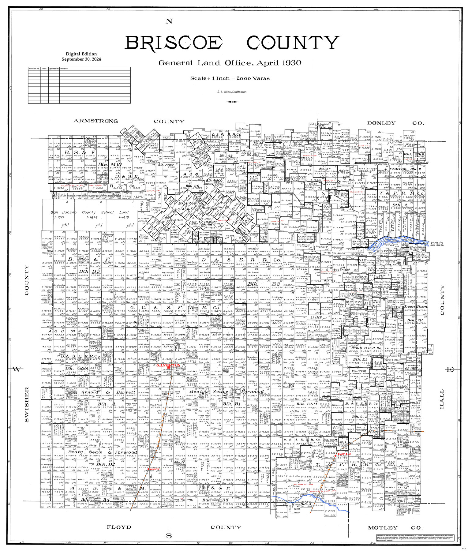
Briscoe County
General Land Office Official County Map
-
Map/Doc
95439
-
Collection
General Map Collection
-
Object Dates
4/1930 (Creation Date)
9/30/2024 (Revision Date)
-
People and Organizations
Cheyenne Betancourt (Draftsman)
J.B. Giles (Draftsman)
-
Counties
Briscoe
-
Subjects
County OCM
-
Height x Width
42.3 x 35.8 inches
107.4 x 90.9 cm
-
Medium
digital image
-
Scale
1" = 2000 varas
Part of: General Map Collection
Wichita County Boundary File 4

Print $20.00
- Digital $50.00
Wichita County Boundary File 4
Size 12.4 x 38.3 inches
Map/Doc 59914
Upton County Rolled Sketch 59

Print $40.00
- Digital $50.00
Upton County Rolled Sketch 59
1994
Size 35.8 x 49.2 inches
Map/Doc 10637
Harris County Working Sketch 122

Print $20.00
- Digital $50.00
Harris County Working Sketch 122
1986
Size 30.0 x 40.1 inches
Map/Doc 66014
Flight Mission No. BQY-4M, Frame 126, Harris County

Print $20.00
- Digital $50.00
Flight Mission No. BQY-4M, Frame 126, Harris County
1953
Size 18.5 x 22.2 inches
Map/Doc 85295
Travis County Rolled Sketch 11

Print $20.00
- Digital $50.00
Travis County Rolled Sketch 11
Size 23.3 x 37.9 inches
Map/Doc 8014
Upton County Sketch File 20

Print $40.00
- Digital $50.00
Upton County Sketch File 20
1927
Size 18.5 x 29.2 inches
Map/Doc 12516
Rio Grande Rectification Project, El Paso and Juarez Valley

Print $20.00
- Digital $50.00
Rio Grande Rectification Project, El Paso and Juarez Valley
1935
Size 10.8 x 29.6 inches
Map/Doc 60872
Cram's Superior Map of Illinois

Print $40.00
- Digital $50.00
Cram's Superior Map of Illinois
1903
Size 50.2 x 40.5 inches
Map/Doc 97110
Edwards County Working Sketch 45

Print $40.00
- Digital $50.00
Edwards County Working Sketch 45
1950
Size 65.4 x 43.4 inches
Map/Doc 68921
Anderson County Boundary File 6

Print $9.00
- Digital $50.00
Anderson County Boundary File 6
Size 14.3 x 8.7 inches
Map/Doc 49747
Bexar County Sketch File 9

Print $4.00
- Digital $50.00
Bexar County Sketch File 9
1853
Size 8.2 x 13.2 inches
Map/Doc 14479
Webb County Rolled Sketch 56

Print $20.00
- Digital $50.00
Webb County Rolled Sketch 56
1945
Size 22.2 x 23.7 inches
Map/Doc 8208
You may also like
Flight Mission No. CRC-4R, Frame 108, Chambers County

Print $20.00
- Digital $50.00
Flight Mission No. CRC-4R, Frame 108, Chambers County
1956
Size 18.7 x 22.4 inches
Map/Doc 84905
Sketch for Mineral Application 33721 - 33725 Incl (Attorney General) - Map of Padre Island - Cameron, Willacy, Kleberg, Nueces and Kenedy Counties.

Print $20.00
- Digital $50.00
Sketch for Mineral Application 33721 - 33725 Incl (Attorney General) - Map of Padre Island - Cameron, Willacy, Kleberg, Nueces and Kenedy Counties.
Size 43.3 x 23.1 inches
Map/Doc 65663
San Saba County Boundary File 1

Print $4.00
- Digital $50.00
San Saba County Boundary File 1
Size 14.2 x 8.7 inches
Map/Doc 58575
Gonzales County Rolled Sketch 1

Print $20.00
- Digital $50.00
Gonzales County Rolled Sketch 1
1917
Size 21.9 x 23.9 inches
Map/Doc 6027
Events of the Texas Revolution

Events of the Texas Revolution
2023
Size 8.5 x 11.0 inches
Map/Doc 97188
Palo Pinto County, Texas

Print $20.00
- Digital $50.00
Palo Pinto County, Texas
1871
Size 28.8 x 23.4 inches
Map/Doc 660
Flight Mission No. CGI-4N, Frame 191, Cameron County

Print $20.00
- Digital $50.00
Flight Mission No. CGI-4N, Frame 191, Cameron County
1955
Size 18.6 x 22.2 inches
Map/Doc 84694
Polk County Working Sketch 8

Print $20.00
- Digital $50.00
Polk County Working Sketch 8
1934
Size 24.2 x 30.5 inches
Map/Doc 71623
Travels to the source of the Missouri River and across the American Continent to the Pacific Ocean - Vol. 2

Travels to the source of the Missouri River and across the American Continent to the Pacific Ocean - Vol. 2
1815
Map/Doc 97413
Flight Mission No. CRE-2R, Frame 159, Jackson County

Print $20.00
- Digital $50.00
Flight Mission No. CRE-2R, Frame 159, Jackson County
1956
Size 18.5 x 22.2 inches
Map/Doc 85370
Wichita County Sketch File 2

Print $8.00
- Digital $50.00
Wichita County Sketch File 2
Size 9.0 x 10.8 inches
Map/Doc 40030
Map of the United States, Canada and a part of Mexico to illustrate Olney's school geography

Print $20.00
- Digital $50.00
Map of the United States, Canada and a part of Mexico to illustrate Olney's school geography
1844
Size 12.1 x 19.0 inches
Map/Doc 93537