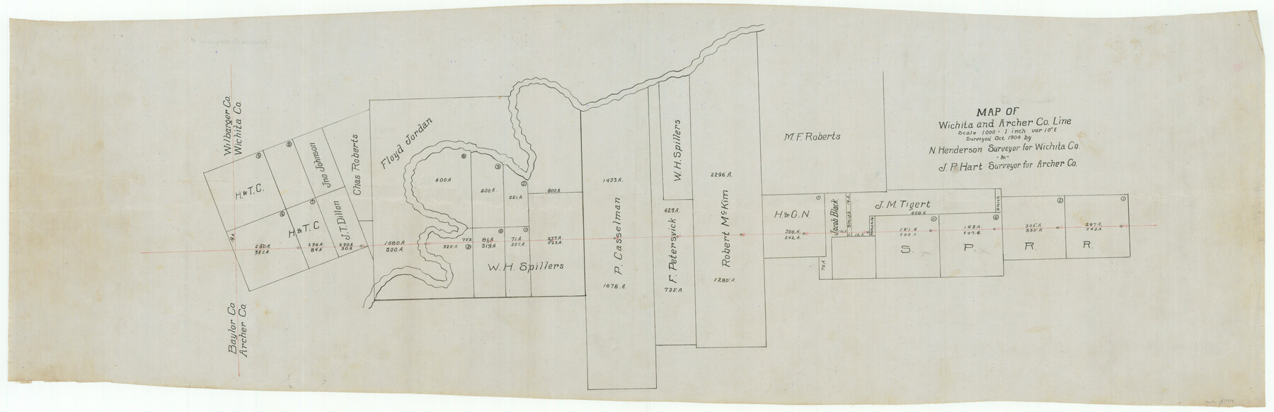
Wichita County Boundary File 4
Map of Wichita and Archer Co. Line
- 
                          Map/Doc59914
- 
                            CollectionGeneral Map Collection
- 
                            CountiesWichita
- 
                            SubjectsCounty Boundaries
- 
                            Height x Width12.4 x 38.3 inches31.5 x 97.3 cm
Part of: General Map Collection
            Erath County Sketch File 19


                                            Print $4.00                    
                                             -                         Digital $50.00                                    
                Erath County Sketch File 19
1891
Size 8.4 x 12.9 inches
                                Map/Doc 22298
            
            Brewster County Working Sketch 5


                                            Print $20.00                    
                                             -                         Digital $50.00                                    
                Brewster County Working Sketch 5
1908
Size 28.0 x 22.0 inches
                                Map/Doc 67538
            
            Red River County


                                            Print $20.00                    
                                             -                         Digital $50.00                                    
                Red River County
1896
Size 24.3 x 21.5 inches
                                Map/Doc 3977
            
            [Sketch for Mineral Application 26546 - Sabine River between Hawkins Creek and east boundary line of BBB&C RR Co. Surveys, R. S. Rathke]
            
                                    ![65665, [Sketch for Mineral Application 26546 - Sabine River between Hawkins Creek and east boundary line of BBB&C RR Co. Surveys, R. S. Rathke], General Map Collection](https://historictexasmaps.com/wmedia_w700/maps/65665.tif.jpg) 


    ![65665, [Sketch for Mineral Application 26546 - Sabine River between Hawkins Creek and east boundary line of BBB&C RR Co. Surveys, R. S. Rathke], General Map Collection](https://historictexasmaps.com/wmedia_w700/maps/65665.tif.jpg) 
                                
            
                                            Print $40.00                    
                                             -                         Digital $50.00                                    
                [Sketch for Mineral Application 26546 - Sabine River between Hawkins Creek and east boundary line of BBB&C RR Co. Surveys, R. S. Rathke]
1931
Size 25.5 x 75.1 inches
                                Map/Doc 65665
            
            Castro County Sketch File 4c


                                            Print $4.00                    
                                             -                         Digital $50.00                                    
                Castro County Sketch File 4c
Size 12.7 x 8.8 inches
                                Map/Doc 17469
            
            Parker County Working Sketch 14


                                            Print $20.00                    
                                             -                         Digital $50.00                                    
                Parker County Working Sketch 14
1980
Map/Doc 71464
            
            Map of Galveston, Turtle & East Bays & Portion of the Gulf of Mexico in Chambers & Galveston Counties, Texas Showing Subdivision Thereof for Mineral Development


                                            Print $40.00                    
                                             -                         Digital $50.00                                    
                Map of Galveston, Turtle & East Bays & Portion of the Gulf of Mexico in Chambers & Galveston Counties, Texas Showing Subdivision Thereof for Mineral Development
1935
Size 43.6 x 51.1 inches
                                Map/Doc 78633
            
            Flight Mission No. DCL-6C, Frame 69, Kenedy County


                                            Print $20.00                    
                                             -                         Digital $50.00                                    
                Flight Mission No. DCL-6C, Frame 69, Kenedy County
1943
Size 18.6 x 22.3 inches
                                Map/Doc 85911
            
            Cherokee County Sketch File 28


                                            Print $6.00                    
                                             -                         Digital $50.00                                    
                Cherokee County Sketch File 28
1916
Size 11.0 x 14.0 inches
                                Map/Doc 18173
            
            Flight Mission No. BRA-7M, Frame 20, Jefferson County


                                            Print $20.00                    
                                             -                         Digital $50.00                                    
                Flight Mission No. BRA-7M, Frame 20, Jefferson County
1953
Size 18.6 x 22.2 inches
                                Map/Doc 85471
            
            Gillespie County Working Sketch 2


                                            Print $20.00                    
                                             -                         Digital $50.00                                    
                Gillespie County Working Sketch 2
1958
Size 35.9 x 26.0 inches
                                Map/Doc 63165
            
            Polk County Sketch File 3


                                            Print $10.00                    
                                             -                         Digital $50.00                                    
                Polk County Sketch File 3
1848
Size 8.5 x 7.6 inches
                                Map/Doc 34122
            You may also like
            Jefferson County Sketch File 44


                                            Print $20.00                    
                                             -                         Digital $50.00                                    
                Jefferson County Sketch File 44
1917
Size 22.8 x 32.9 inches
                                Map/Doc 11878
            
            East Part of Edwards County


                                            Print $40.00                    
                                             -                         Digital $50.00                                    
                East Part of Edwards County
1975
Size 55.7 x 40.5 inches
                                Map/Doc 73138
            
            Flight Mission No. DCL-7C, Frame 46, Kenedy County


                                            Print $20.00                    
                                             -                         Digital $50.00                                    
                Flight Mission No. DCL-7C, Frame 46, Kenedy County
1943
Size 15.4 x 15.3 inches
                                Map/Doc 86034
            
            Liberty County Rolled Sketch G


                                            Print $20.00                    
                                             -                         Digital $50.00                                    
                Liberty County Rolled Sketch G
Size 25.7 x 25.2 inches
                                Map/Doc 6622
            
            Flight Mission No. CUG-3P, Frame 43, Kleberg County


                                            Print $20.00                    
                                             -                         Digital $50.00                                    
                Flight Mission No. CUG-3P, Frame 43, Kleberg County
1956
Size 18.6 x 22.3 inches
                                Map/Doc 86248
            
            Palo Pinto County Sketch File 8


                                            Print $40.00                    
                                             -                         Digital $50.00                                    
                Palo Pinto County Sketch File 8
Size 15.3 x 15.6 inches
                                Map/Doc 33400
            
            Cameron County Rolled Sketch Z6


                                            Print $20.00                    
                                             -                         Digital $50.00                                    
                Cameron County Rolled Sketch Z6
1937
Size 28.3 x 33.8 inches
                                Map/Doc 5404
            
            Flight Mission No. DQN-3K, Frame 50, Calhoun County


                                            Print $20.00                    
                                             -                         Digital $50.00                                    
                Flight Mission No. DQN-3K, Frame 50, Calhoun County
1953
Size 18.4 x 22.2 inches
                                Map/Doc 84351
            
            Webb County Sketch File LM3


                                            Print $20.00                    
                                             -                         Digital $50.00                                    
                Webb County Sketch File LM3
1924
Size 24.7 x 31.9 inches
                                Map/Doc 12658
            
            Aransas County NRC Article 33.136 Sketch 9


                                            Print $24.00                    
                                             -                         Digital $50.00                                    
                Aransas County NRC Article 33.136 Sketch 9
2013
Size 24.0 x 36.0 inches
                                Map/Doc 94469
            
            Station Map, the Missouri, Kansas and Texas Ry. Of Texas - Henrietta Division


                                            Print $20.00                    
                                             -                         Digital $50.00                                    
                Station Map, the Missouri, Kansas and Texas Ry. Of Texas - Henrietta Division
1918
Size 11.8 x 26.7 inches
                                Map/Doc 64763
             
                            