Crosby County Rolled Sketch R
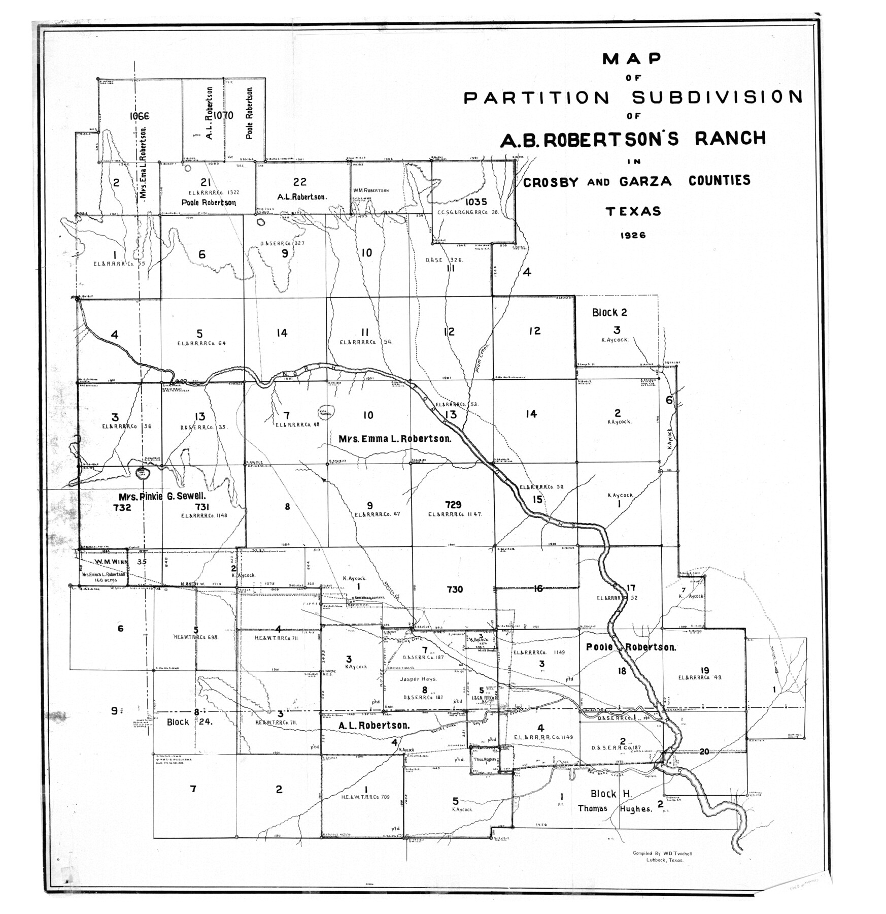
Map of partition subdivision of A.B. Robertson's Ranch in Crosby and Garza Counties, Texas
-
Map/Doc
8740
-
Collection
General Map Collection
-
Object Dates
1935/3/6 (File Date)
1926 (Creation Date)
-
People and Organizations
W.D. Twichell (Surveyor/Engineer)
W.D. Twichell (Compiler)
-
Counties
Crosby Garza
-
Subjects
Surveying Rolled Sketch
-
Height x Width
41.2 x 40.0 inches
104.6 x 101.6 cm
-
Comments
See Crosby County Sketch File 36 (20108) for surveyor’s statement.
Related maps
Crosby County Sketch File 36

Print $4.00
- Digital $50.00
Crosby County Sketch File 36
1935
Size 7.5 x 9.2 inches
Map/Doc 20108
Part of: General Map Collection
Flight Mission No. CRC-3R, Frame 55, Chambers County

Print $20.00
- Digital $50.00
Flight Mission No. CRC-3R, Frame 55, Chambers County
1956
Size 18.6 x 22.4 inches
Map/Doc 84827
Rusk County Working Sketch 36

Print $20.00
- Digital $50.00
Rusk County Working Sketch 36
2007
Size 31.7 x 36.0 inches
Map/Doc 83786
The Coast of New Spain from Neuva Vera Cruz to Triste Island

Print $20.00
- Digital $50.00
The Coast of New Spain from Neuva Vera Cruz to Triste Island
1775
Size 21.0 x 28.9 inches
Map/Doc 95919
Bailey County Rolled Sketch 7

Print $40.00
- Digital $50.00
Bailey County Rolled Sketch 7
1941
Size 67.1 x 43.1 inches
Map/Doc 8931
Marion County Working Sketch Graphic Index, Sheet 1 (Sketches 1 to 26)

Print $20.00
- Digital $50.00
Marion County Working Sketch Graphic Index, Sheet 1 (Sketches 1 to 26)
1943
Size 26.8 x 45.1 inches
Map/Doc 76629
Kinney County Sketch File 39

Print $20.00
- Digital $50.00
Kinney County Sketch File 39
1948
Size 18.8 x 21.0 inches
Map/Doc 11951
Map of the country adjacent to the left bank of the Rio Grande below Matamoros

Print $20.00
- Digital $50.00
Map of the country adjacent to the left bank of the Rio Grande below Matamoros
1847
Size 18.3 x 27.3 inches
Map/Doc 72868
La Salle County Sketch File 33

Print $2.00
- Digital $50.00
La Salle County Sketch File 33
1875
Size 13.4 x 8.0 inches
Map/Doc 29584
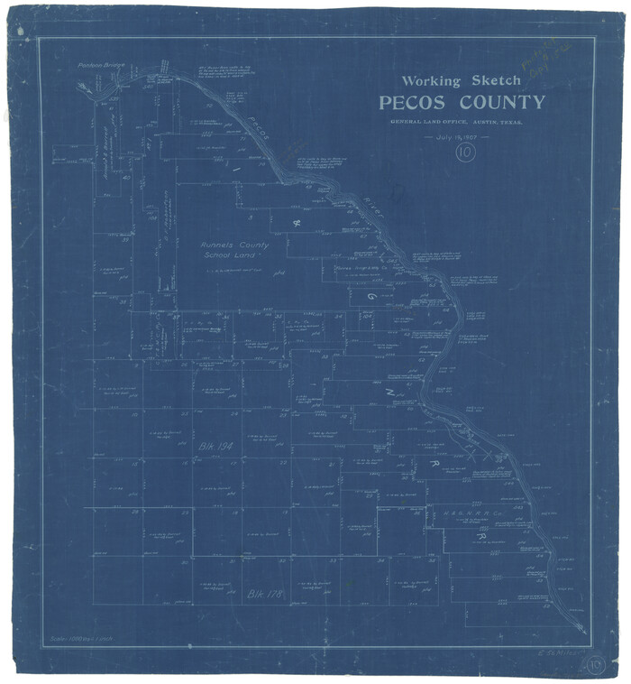
Pecos County Working Sketch 10
Print $20.00
- Digital $50.00
Pecos County Working Sketch 10
1907
Size 25.9 x 23.9 inches
Map/Doc 71480
Fort Bend County Rolled Sketch 9

Print $20.00
- Digital $50.00
Fort Bend County Rolled Sketch 9
1920
Size 21.0 x 24.7 inches
Map/Doc 5899
Tom Green County Sketch File 83

Print $20.00
- Digital $50.00
Tom Green County Sketch File 83
1889
Size 20.5 x 22.2 inches
Map/Doc 12455
Concho County Sketch File 8 1/2

Print $8.00
- Digital $50.00
Concho County Sketch File 8 1/2
1887
Size 8.4 x 10.6 inches
Map/Doc 19134
You may also like
[Beaumont, Sour Lake and Western Ry. Right of Way and Alignment - Frisco]
![64121, [Beaumont, Sour Lake and Western Ry. Right of Way and Alignment - Frisco], General Map Collection](https://historictexasmaps.com/wmedia_w700/maps/64121.tif.jpg)
Print $20.00
- Digital $50.00
[Beaumont, Sour Lake and Western Ry. Right of Way and Alignment - Frisco]
1910
Size 20.0 x 45.8 inches
Map/Doc 64121
Copy of Surveyor's Field Book, Morris Browning - In Blocks 7, 5 & 4, I&GNRRCo., Hutchinson and Carson Counties, Texas

Print $2.00
- Digital $50.00
Copy of Surveyor's Field Book, Morris Browning - In Blocks 7, 5 & 4, I&GNRRCo., Hutchinson and Carson Counties, Texas
1888
Size 6.9 x 8.8 inches
Map/Doc 62262
Cottle County

Print $20.00
- Digital $50.00
Cottle County
1908
Size 45.0 x 41.0 inches
Map/Doc 66789

Wilson County Sketch File 12

Print $8.00
- Digital $50.00
Wilson County Sketch File 12
1841
Size 14.1 x 8.6 inches
Map/Doc 40425
Ellwood Farms Subdivision Number 2 of the Spade Ranch Lamb and Hale Counties, Texas

Print $20.00
- Digital $50.00
Ellwood Farms Subdivision Number 2 of the Spade Ranch Lamb and Hale Counties, Texas
Size 20.9 x 29.1 inches
Map/Doc 92173
Dallas County Boundary File 8 and 8a

Print $16.00
- Digital $50.00
Dallas County Boundary File 8 and 8a
Size 11.3 x 8.6 inches
Map/Doc 52304
Brewster County Working Sketch 111

Print $40.00
- Digital $50.00
Brewster County Working Sketch 111
1982
Size 21.5 x 55.9 inches
Map/Doc 67711
Flight Mission No. DIX-10P, Frame 179, Aransas County

Print $20.00
- Digital $50.00
Flight Mission No. DIX-10P, Frame 179, Aransas County
1956
Size 18.7 x 22.3 inches
Map/Doc 83969
Crockett County Working Sketch 9

Print $20.00
- Digital $50.00
Crockett County Working Sketch 9
1912
Size 24.2 x 32.1 inches
Map/Doc 68342
[J. Blackwell survey 150, E. Parker, Asa Dorsett survey 827 and surrounding surveys]
![90422, [J. Blackwell survey 150, E. Parker, Asa Dorsett survey 827 and surrounding surveys], Twichell Survey Records](https://historictexasmaps.com/wmedia_w700/maps/90422-1.tif.jpg)
Print $20.00
- Digital $50.00
[J. Blackwell survey 150, E. Parker, Asa Dorsett survey 827 and surrounding surveys]
Size 35.0 x 30.3 inches
Map/Doc 90422
[R. T. Bucy's Survey 3, League 321]
![91296, [R. T. Bucy's Survey 3, League 321], Twichell Survey Records](https://historictexasmaps.com/wmedia_w700/maps/91296-1.tif.jpg)
Print $20.00
- Digital $50.00
[R. T. Bucy's Survey 3, League 321]
Size 12.2 x 19.1 inches
Map/Doc 91296