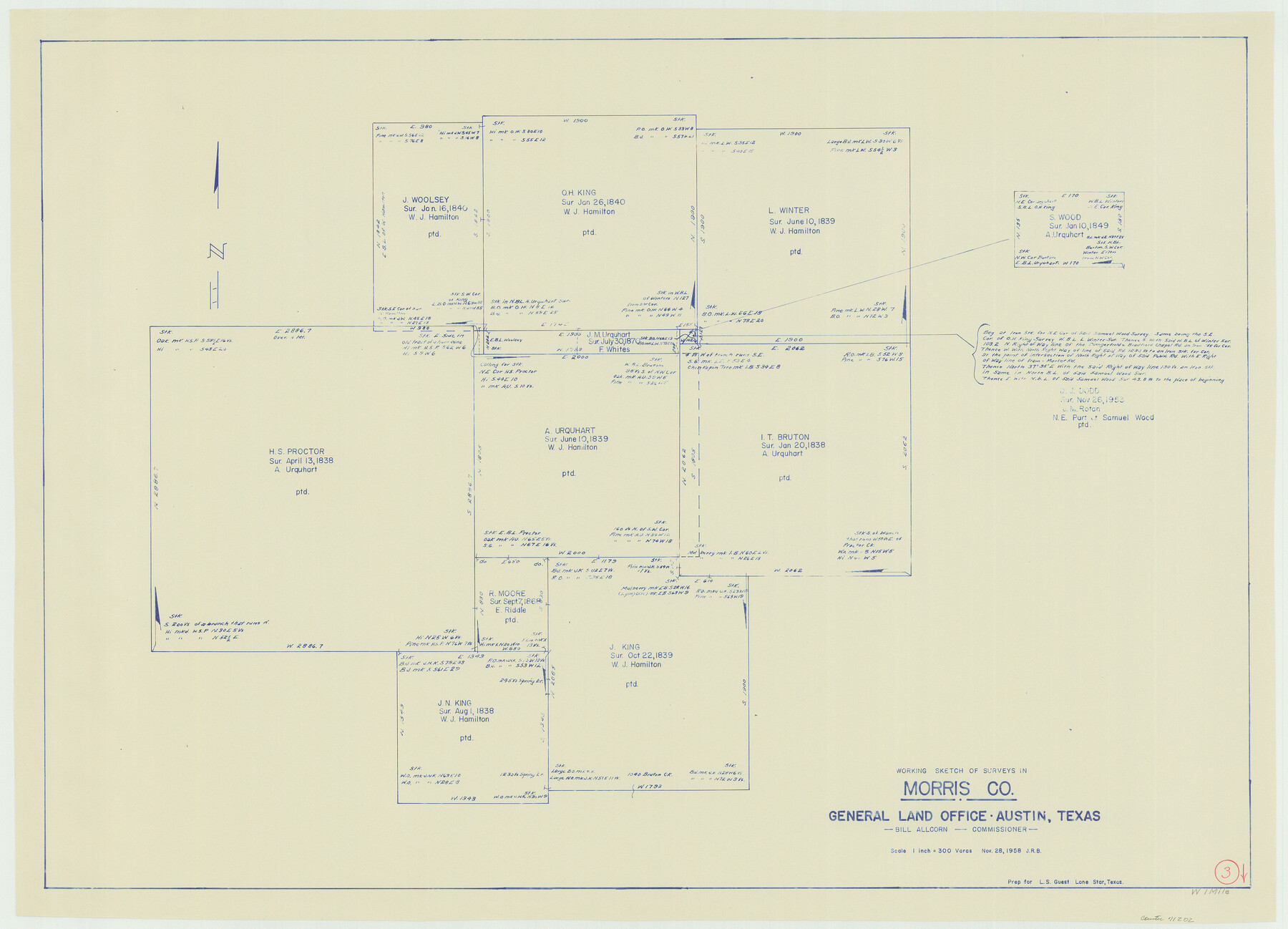
Morris County Working Sketch 3
-
Map/Doc
71202
-
Collection
General Map Collection
-
Object Dates
11/28/1958 (Creation Date)
-
Counties
Morris
-
Subjects
Surveying Working Sketch
-
Height x Width
27.6 x 38.2 inches
70.1 x 97.0 cm
-
Scale
1" = 300 varas
Part of: General Map Collection
Railroad and County Map of Texas

Print $20.00
- Digital $50.00
Railroad and County Map of Texas
1926
Size 42.9 x 45.2 inches
Map/Doc 65799
Flight Mission No. CRC-2R, Frame 178, Chambers County

Print $20.00
- Digital $50.00
Flight Mission No. CRC-2R, Frame 178, Chambers County
1956
Size 18.6 x 22.4 inches
Map/Doc 84756
Aransas County Working Sketch 5

Print $20.00
- Digital $50.00
Aransas County Working Sketch 5
1928
Size 19.7 x 23.2 inches
Map/Doc 67172
Schleicher County Sketch File 3

Print $20.00
- Digital $50.00
Schleicher County Sketch File 3
Size 28.1 x 19.9 inches
Map/Doc 12295
Tom Green County Working Sketch 15

Print $20.00
- Digital $50.00
Tom Green County Working Sketch 15
1988
Size 32.9 x 37.5 inches
Map/Doc 69384
Nueces County Rolled Sketch 4

Print $20.00
- Digital $50.00
Nueces County Rolled Sketch 4
1910
Size 39.8 x 38.5 inches
Map/Doc 9583
Ward County Rolled Sketch 29

Print $20.00
- Digital $50.00
Ward County Rolled Sketch 29
Size 31.8 x 27.4 inches
Map/Doc 89287
Kinney County Rolled Sketch O

Print $20.00
- Digital $50.00
Kinney County Rolled Sketch O
1848
Size 32.1 x 36.2 inches
Map/Doc 6547
Hardeman County Sketch File 18

Print $8.00
- Digital $50.00
Hardeman County Sketch File 18
Size 13.1 x 8.2 inches
Map/Doc 25026
Flight Mission No. DAG-26K, Frame 62, Matagorda County

Print $20.00
- Digital $50.00
Flight Mission No. DAG-26K, Frame 62, Matagorda County
1953
Size 18.7 x 22.5 inches
Map/Doc 86582
Brazoria County State Real Property Sketch 2

Print $60.00
- Digital $50.00
Brazoria County State Real Property Sketch 2
2003
Size 31.0 x 42.9 inches
Map/Doc 83356
El Paso County Rolled Sketch 22

Print $40.00
- Digital $50.00
El Paso County Rolled Sketch 22
1888
Size 38.8 x 95.1 inches
Map/Doc 8859
You may also like
Novissima et Accuratissima Totius Americae Descriptio

Print $20.00
- Digital $50.00
Novissima et Accuratissima Totius Americae Descriptio
1677
Size 20.9 x 25.0 inches
Map/Doc 93819
Flight Mission No. DQN-2K, Frame 39, Calhoun County

Print $20.00
- Digital $50.00
Flight Mission No. DQN-2K, Frame 39, Calhoun County
1953
Size 18.2 x 22.2 inches
Map/Doc 84244
Flight Mission No. CRC-3R, Frame 197, Chambers County

Print $20.00
- Digital $50.00
Flight Mission No. CRC-3R, Frame 197, Chambers County
1956
Size 18.5 x 22.3 inches
Map/Doc 84852
Flight Mission No. CRC-3R, Frame 95, Chambers County

Print $20.00
- Digital $50.00
Flight Mission No. CRC-3R, Frame 95, Chambers County
1956
Size 18.6 x 22.4 inches
Map/Doc 84833
El Paso County Working Sketch 34

Print $40.00
- Digital $50.00
El Paso County Working Sketch 34
1974
Size 53.4 x 34.7 inches
Map/Doc 69056
Cottle County Sketch File 4

Print $16.00
- Digital $50.00
Cottle County Sketch File 4
Size 8.2 x 4.2 inches
Map/Doc 19466
Cass County Rolled Sketch 5A

Print $20.00
- Digital $50.00
Cass County Rolled Sketch 5A
Size 15.4 x 18.0 inches
Map/Doc 5411
[John Walker and vicinity]
![90914, [John Walker and vicinity], Twichell Survey Records](https://historictexasmaps.com/wmedia_w700/maps/90914-1.tif.jpg)
Print $20.00
- Digital $50.00
[John Walker and vicinity]
Size 27.0 x 27.3 inches
Map/Doc 90914
Brewster County Sketch File 45

Print $2.00
- Digital $50.00
Brewster County Sketch File 45
Size 10.7 x 8.2 inches
Map/Doc 16312
Kinney County Working Sketch 4

Print $20.00
- Digital $50.00
Kinney County Working Sketch 4
1907
Size 21.1 x 21.6 inches
Map/Doc 70186
Hamilton County Sketch File 15

Print $2.00
- Digital $50.00
Hamilton County Sketch File 15
1882
Size 8.0 x 11.8 inches
Map/Doc 24941
[Map of Texas and Pacific Blocks from Brazos River westward through Palo Pinto, Stephens, Shackelford, Jones, Callahan, Taylor, Fisher, Nolan and Mitchell Counties]
![64510, [Map of Texas and Pacific Blocks from Brazos River westward through Palo Pinto, Stephens, Shackelford, Jones, Callahan, Taylor, Fisher, Nolan and Mitchell Counties], General Map Collection](https://historictexasmaps.com/wmedia_w700/maps/64510-1.tif.jpg)
Print $20.00
- Digital $50.00
[Map of Texas and Pacific Blocks from Brazos River westward through Palo Pinto, Stephens, Shackelford, Jones, Callahan, Taylor, Fisher, Nolan and Mitchell Counties]
Size 35.5 x 19.0 inches
Map/Doc 64510