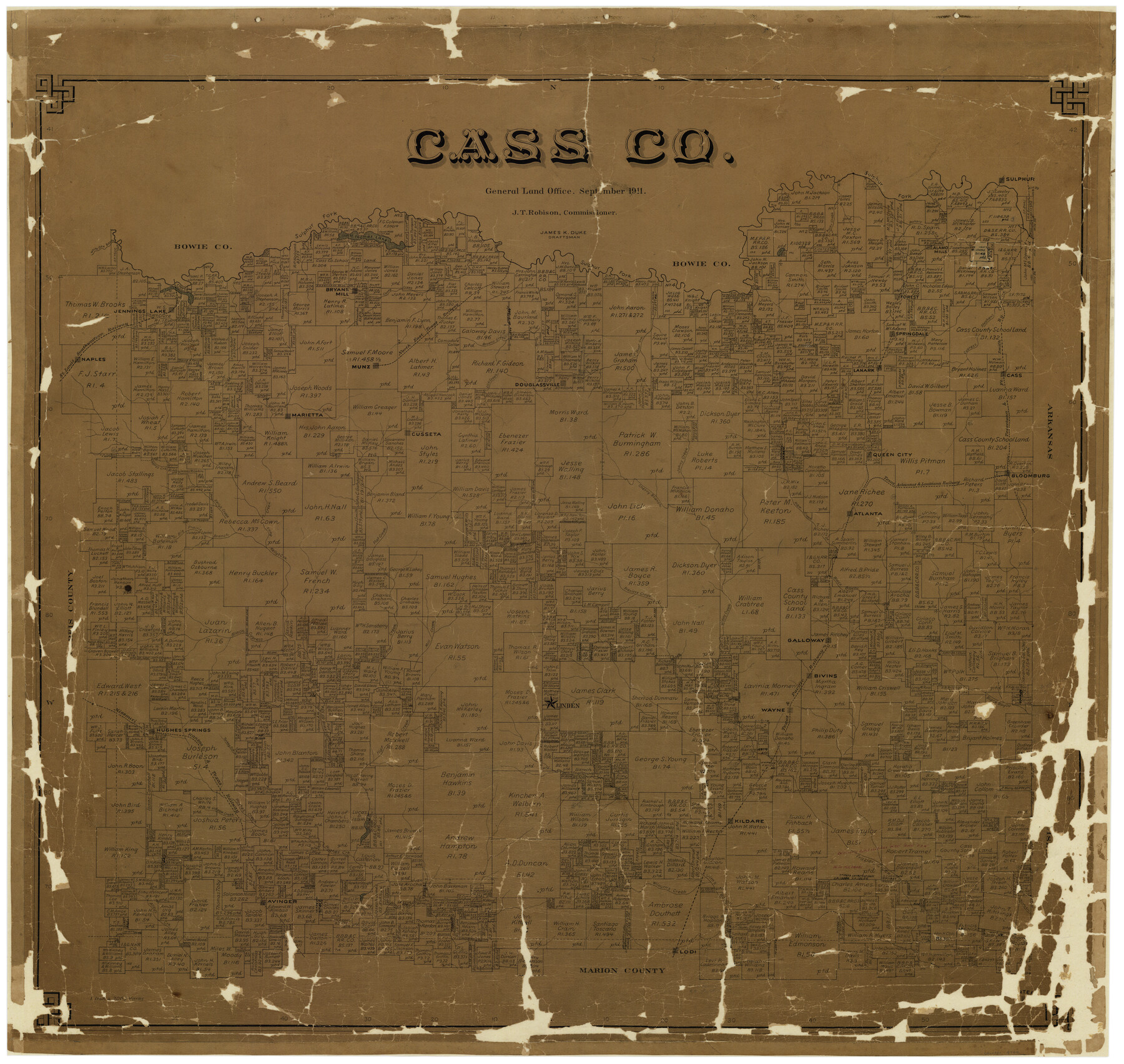
Cass Co.
-
Map/Doc
4749
-
Collection
General Map Collection
-
Object Dates
9/1911 (Creation Date)
-
People and Organizations
Texas General Land Office (Publisher)
James K. Duke (Compiler)
James K. Duke (Draftsman)
-
Counties
Cass
-
Subjects
County
-
Height x Width
38.7 x 41.1 inches
98.3 x 104.4 cm
-
Comments
Conservation funded in 2002 with donations from Dan Hampton and Associates Inc., Morris County National Bank, and Cass County Bank.
-
Features
Bivins
Haw Creek
Atlanta
Bloomburg
Lost Creek
Flat Creek
Bear Creek
Big Prairie Branch of Kelly's Creek
Fraziers Creek
Black Bayou
Galloway
Mill Creek
Black Cypress [Creek]
Linden
Wayne
T&P
Cherry Branch of Johns Creek
Turkey Creek
MK&T
Hughes Springs
Village Creek
Hughes Creek
Kildare
Jim's Bayou
Prewitts Lake
Avinger
Wilburn's Creek
Hunts Creek
Lodi
Alley's Creek
TA&L
NETRR
Thomas Lake
Eppersons Ferry
Sulphur
Alamo Mills
Bakers Creek
Rocky Creek
White Oak Bayou
Jennings Lake
Bryans Mill
Caney Creek
Forest
Stephens Creek
Cypress Creek
Springdale
Browns Creek
Sulphur Fork [of Red River]
Flemings Creek
Jennings Lake
Halls Creek
SLS
Naples
Marietta
Munz
Lick Creek
Douglassville
T&FS
Cass
Cusseta
Kelly's Creek
Johns Creek
Part of: General Map Collection
Hardin County Sketch File 55

Print $40.00
- Digital $50.00
Hardin County Sketch File 55
1924
Size 14.2 x 13.3 inches
Map/Doc 25220
Shackelford County Sketch File 4

Print $40.00
- Digital $50.00
Shackelford County Sketch File 4
Size 38.5 x 53.7 inches
Map/Doc 10600
General Homes Free Houston Area Map

General Homes Free Houston Area Map
Size 27.1 x 42.5 inches
Map/Doc 94393
Flight Mission No. BQY-4M, Frame 38, Harris County

Print $20.00
- Digital $50.00
Flight Mission No. BQY-4M, Frame 38, Harris County
1953
Size 18.6 x 22.4 inches
Map/Doc 85253
Starr County Rolled Sketch 24

Print $20.00
- Digital $50.00
Starr County Rolled Sketch 24
1938
Size 37.5 x 26.7 inches
Map/Doc 7808
Midland County

Print $20.00
- Digital $50.00
Midland County
1930
Size 45.7 x 39.6 inches
Map/Doc 66930
Bexar County State Real Property Sketch 1

Print $20.00
- Digital $50.00
Bexar County State Real Property Sketch 1
1992
Size 30.0 x 42.2 inches
Map/Doc 61698
Crockett County Working Sketch 81

Print $20.00
- Digital $50.00
Crockett County Working Sketch 81
1973
Size 28.1 x 37.7 inches
Map/Doc 68414
Amistad International Reservoir on Rio Grande 92

Print $20.00
- Digital $50.00
Amistad International Reservoir on Rio Grande 92
1950
Size 28.5 x 40.6 inches
Map/Doc 75522
Engineer's Office, Department of the Gulf Map No. 59, Texas prepared by order of Maj. Gen. N. P. Banks under direction of Capt. P. C. Hains, U. S. Engr. & Chief Engr., Dept. of the Gulf

Print $20.00
- Digital $50.00
Engineer's Office, Department of the Gulf Map No. 59, Texas prepared by order of Maj. Gen. N. P. Banks under direction of Capt. P. C. Hains, U. S. Engr. & Chief Engr., Dept. of the Gulf
1865
Size 18.2 x 27.5 inches
Map/Doc 72718
Dimmit County Rolled Sketch 2

Print $20.00
- Digital $50.00
Dimmit County Rolled Sketch 2
Size 33.9 x 39.6 inches
Map/Doc 8793
Crockett County Rolled Sketch 42

Print $20.00
- Digital $50.00
Crockett County Rolled Sketch 42
Size 24.4 x 24.7 inches
Map/Doc 5592
You may also like
Railroad Track Map, H&TCRRCo., Falls County, Texas

Print $4.00
- Digital $50.00
Railroad Track Map, H&TCRRCo., Falls County, Texas
1918
Size 11.4 x 18.7 inches
Map/Doc 62851
Burleson County Working Sketch Graphic Index

Print $20.00
- Digital $50.00
Burleson County Working Sketch Graphic Index
1978
Size 35.0 x 46.1 inches
Map/Doc 76481
Hudspeth County Working Sketch 33

Print $20.00
- Digital $50.00
Hudspeth County Working Sketch 33
1977
Size 26.8 x 21.4 inches
Map/Doc 66318
Collin County Rolled Sketch 2

Print $20.00
- Digital $50.00
Collin County Rolled Sketch 2
Size 33.3 x 26.1 inches
Map/Doc 8636
Map of Bandera County

Print $20.00
- Digital $50.00
Map of Bandera County
1878
Size 19.3 x 29.4 inches
Map/Doc 3272
Flight Mission No. BRA-16M, Frame 138, Jefferson County

Print $20.00
- Digital $50.00
Flight Mission No. BRA-16M, Frame 138, Jefferson County
1953
Size 18.7 x 22.3 inches
Map/Doc 85744
General Highway Map, Dallam County, Texas

Print $20.00
General Highway Map, Dallam County, Texas
1961
Size 24.6 x 18.3 inches
Map/Doc 79428
Nueces County Sketch File 60

Print $14.00
- Digital $50.00
Nueces County Sketch File 60
1940
Size 11.1 x 8.8 inches
Map/Doc 32962

Haskell County

Print $20.00
- Digital $50.00
Haskell County
1888
Size 38.5 x 37.1 inches
Map/Doc 4700
Flight Mission No. BRE-2P, Frame 131, Nueces County

Print $20.00
- Digital $50.00
Flight Mission No. BRE-2P, Frame 131, Nueces County
1956
Size 18.6 x 22.5 inches
Map/Doc 86804
Crockett County Rolled Sketch 52

Print $20.00
- Digital $50.00
Crockett County Rolled Sketch 52
Size 36.7 x 44.7 inches
Map/Doc 8715