Borden County Sketch File 12
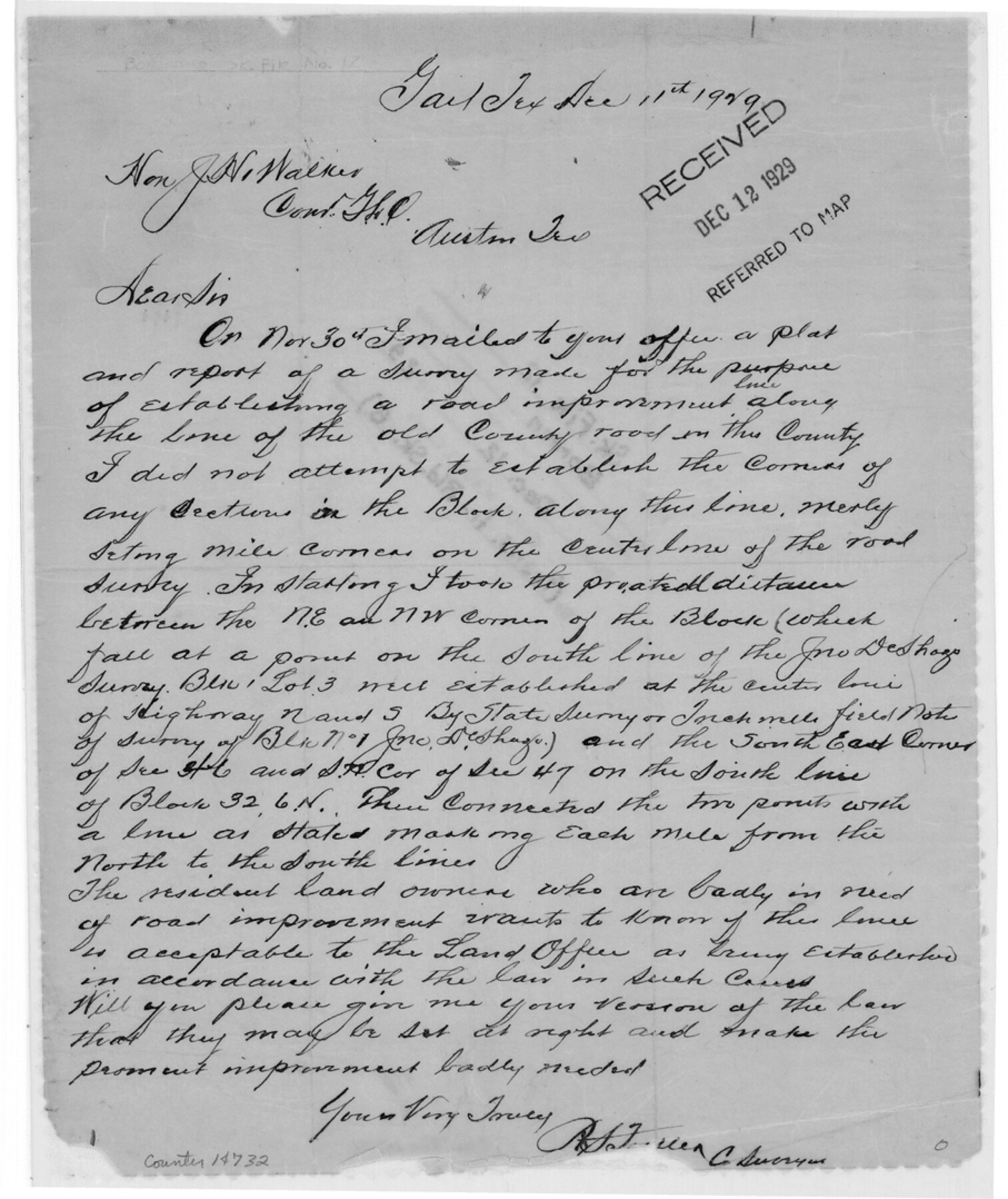
[Copy of report and petition for survey of Block 32, Township 6 North, T. & P. R.R. Co.]
-
Map/Doc
14732
-
Collection
General Map Collection
-
Object Dates
1929/12/11 (Correspondence Date)
1929/12/12 (File Date)
1929/11/29 (Correspondence Date)
-
People and Organizations
R.S. Fuller (Surveyor/Engineer)
-
Counties
Borden
-
Subjects
Surveying Sketch File
-
Height x Width
10.8 x 9.1 inches
27.4 x 23.1 cm
-
Medium
multi-page, multi-format
-
Comments
See Borden County Rolled Sketch 6 (5156) for sketch.
-
Features
Muchuka Peak
Related maps
Borden County Rolled Sketch 6

Print $20.00
- Digital $50.00
Borden County Rolled Sketch 6
Size 24.6 x 18.6 inches
Map/Doc 5156
Part of: General Map Collection
Gillespie County

Print $20.00
- Digital $50.00
Gillespie County
1873
Size 16.0 x 22.4 inches
Map/Doc 3580
Hardin County Rolled Sketch 15

Print $20.00
- Digital $50.00
Hardin County Rolled Sketch 15
Size 26.6 x 29.0 inches
Map/Doc 6086
Crane County Sketch File 7

Print $6.00
- Digital $50.00
Crane County Sketch File 7
1886
Size 10.3 x 11.0 inches
Map/Doc 19567
Hardeman County Boundary File 2

Print $20.00
- Digital $50.00
Hardeman County Boundary File 2
Size 42.0 x 13.5 inches
Map/Doc 54374
Map of Madison County

Print $20.00
- Digital $50.00
Map of Madison County
1858
Size 19.8 x 31.7 inches
Map/Doc 3834
Kaufman County Sketch File 5

Print $22.00
- Digital $50.00
Kaufman County Sketch File 5
1849
Size 7.6 x 12.6 inches
Map/Doc 28632
Northwest Part Crockett County

Print $40.00
- Digital $50.00
Northwest Part Crockett County
1983
Size 37.3 x 48.3 inches
Map/Doc 95470
Lampasas County Boundary File 15a

Print $33.00
- Digital $50.00
Lampasas County Boundary File 15a
Size 13.3 x 8.2 inches
Map/Doc 56210
Jefferson County Rolled Sketch 49

Print $40.00
- Digital $50.00
Jefferson County Rolled Sketch 49
1963
Size 32.5 x 57.4 inches
Map/Doc 66844
Leon County Working Sketch 37

Print $20.00
- Digital $50.00
Leon County Working Sketch 37
1979
Size 43.2 x 37.7 inches
Map/Doc 70436
Texas Intracoastal Waterway, Aransas Bay to Aransas Pass

Print $20.00
- Digital $50.00
Texas Intracoastal Waterway, Aransas Bay to Aransas Pass
1962
Size 38.7 x 26.8 inches
Map/Doc 73439
Grimes County Working Sketch 16

Print $20.00
- Digital $50.00
Grimes County Working Sketch 16
1995
Size 41.6 x 33.1 inches
Map/Doc 63307
You may also like
Terrell County Working Sketch 67

Print $20.00
- Digital $50.00
Terrell County Working Sketch 67
1973
Size 32.8 x 28.2 inches
Map/Doc 69588
Glasscock County Working Sketch 3

Print $20.00
- Digital $50.00
Glasscock County Working Sketch 3
Size 16.8 x 28.0 inches
Map/Doc 63176
Township 2 North Range 11 West, North Western District, Louisiana

Print $20.00
- Digital $50.00
Township 2 North Range 11 West, North Western District, Louisiana
1884
Size 19.7 x 24.7 inches
Map/Doc 65876
Bailey County Sketch File 15

Print $18.00
- Digital $50.00
Bailey County Sketch File 15
1912
Size 8.7 x 11.2 inches
Map/Doc 13975
Orange County Working Sketch 35

Print $20.00
- Digital $50.00
Orange County Working Sketch 35
1959
Size 28.8 x 25.0 inches
Map/Doc 71367
Galveston County Boundary File 32a

Print $10.00
- Digital $50.00
Galveston County Boundary File 32a
Size 11.4 x 8.9 inches
Map/Doc 53666
Crockett County Rolled Sketch 24

Print $20.00
- Digital $50.00
Crockett County Rolled Sketch 24
1924
Size 19.5 x 13.0 inches
Map/Doc 5584
Palo Pinto County

Print $20.00
- Digital $50.00
Palo Pinto County
1879
Size 24.8 x 18.4 inches
Map/Doc 3934
Flight Mission No. CUG-1P, Frame 74, Kleberg County

Print $20.00
- Digital $50.00
Flight Mission No. CUG-1P, Frame 74, Kleberg County
1956
Size 18.5 x 22.3 inches
Map/Doc 86139
Newton County Sketch File 4c

Print $4.00
- Digital $50.00
Newton County Sketch File 4c
Size 7.4 x 8.2 inches
Map/Doc 32366
Lamar County State Real Property Sketch 1

Print $20.00
- Digital $50.00
Lamar County State Real Property Sketch 1
2013
Size 24.0 x 36.0 inches
Map/Doc 93659
Pecos County Rolled Sketch 173

Print $20.00
- Digital $50.00
Pecos County Rolled Sketch 173
Size 32.2 x 35.6 inches
Map/Doc 9751