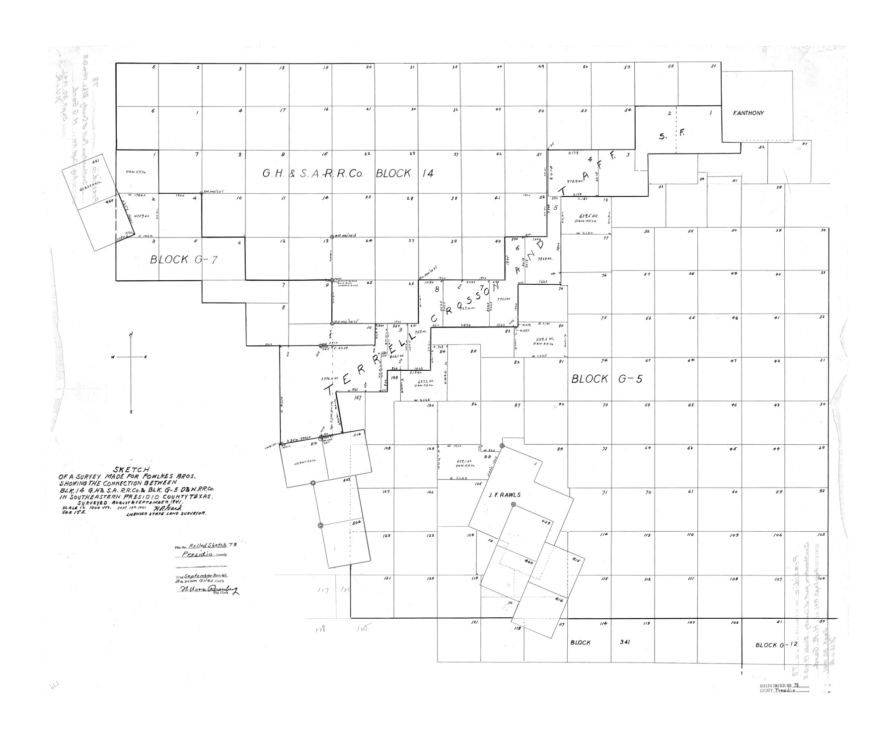
Presidio County Rolled Sketch 78
Sketch of a survey made for Fowlkes Bros. showing the connection between Blk. 14, G. H. & S. A. R.R. Co. & Blk. G-5, D. & W. R.R. Co. in southeastern Presidio County, Texas
-
Map/Doc
7364
-
Collection
General Map Collection
-
Object Dates
1941 (Survey Date)
1941/9/30 (File Date)
1941/9/19 (Creation Date)
-
People and Organizations
H.R. Gard (Surveyor/Engineer)
-
Counties
Presidio Brewster
-
Subjects
Surveying Rolled Sketch
-
Height x Width
32.4 x 39.2 inches
82.3 x 99.6 cm
-
Scale
1" = 1000 varas
-
Comments
See Presidio County Sketch File 68 (34662) for report.
Related maps
Presidio County Sketch File 68

Print $4.00
- Digital $50.00
Presidio County Sketch File 68
1941
Size 11.2 x 8.8 inches
Map/Doc 34662
Part of: General Map Collection
Hamilton County Working Sketch 33

Print $20.00
- Digital $50.00
Hamilton County Working Sketch 33
Size 32.3 x 33.3 inches
Map/Doc 63371
Zapata County Working Sketch 4

Print $20.00
- Digital $50.00
Zapata County Working Sketch 4
1935
Size 19.6 x 22.1 inches
Map/Doc 62055
Scurry County Rolled Sketch 6

Print $20.00
- Digital $50.00
Scurry County Rolled Sketch 6
1944
Size 29.0 x 28.8 inches
Map/Doc 7766

Topographical Map of the Rio Grande, Sheet No. 20

Print $20.00
- Digital $50.00
Topographical Map of the Rio Grande, Sheet No. 20
1912
Map/Doc 89544
Harrison County Working Sketch 13

Print $20.00
- Digital $50.00
Harrison County Working Sketch 13
1961
Size 32.4 x 37.0 inches
Map/Doc 66033
Trinity River, Flagg Lake Sheet/Cedar Creek

Print $20.00
- Digital $50.00
Trinity River, Flagg Lake Sheet/Cedar Creek
1927
Size 37.4 x 30.7 inches
Map/Doc 65219

Hutchinson County Working Sketch 22

Print $40.00
- Digital $50.00
Hutchinson County Working Sketch 22
1966
Size 67.9 x 35.5 inches
Map/Doc 66382

Shelby County Rolled Sketch 10

Print $20.00
- Digital $50.00
Shelby County Rolled Sketch 10
Size 16.2 x 27.3 inches
Map/Doc 7778

You may also like
Wharton County Sketch File 17

Print $12.00
- Digital $50.00
Wharton County Sketch File 17
1898
Size 12.8 x 8.1 inches
Map/Doc 39969
Map of Block 1, H. & G. N. Railroad Company

Print $20.00
- Digital $50.00
Map of Block 1, H. & G. N. Railroad Company
1909
Size 24.0 x 30.1 inches
Map/Doc 91017
Wise County Sketch File 2

Print $8.00
- Digital $50.00
Wise County Sketch File 2
1856
Size 8.2 x 13.4 inches
Map/Doc 40523
Brazoria County Rolled Sketch 39
Print $20.00
- Digital $50.00
Brazoria County Rolled Sketch 39
1949
Size 22.8 x 34.8 inches
Map/Doc 5174
Zapata County Working Sketch 8

Print $20.00
- Digital $50.00
Zapata County Working Sketch 8
1949
Size 25.3 x 23.1 inches
Map/Doc 62059

Garza County Sketch File J

Print $20.00
- Digital $50.00
Garza County Sketch File J
1911
Size 26.5 x 7.5 inches
Map/Doc 11555
Hidalgo County Sketch File 16

Print $12.00
- Digital $50.00
Hidalgo County Sketch File 16
1914
Size 11.2 x 8.9 inches
Map/Doc 26437
King County Working Sketch 18

Print $20.00
- Digital $50.00
King County Working Sketch 18
1994
Size 31.3 x 35.1 inches
Map/Doc 70182
United States - Gulf Coast - From Latitude 26° 33' to the Rio Grande Texas

Print $20.00
- Digital $50.00
United States - Gulf Coast - From Latitude 26° 33' to the Rio Grande Texas
1913
Size 27.9 x 18.2 inches
Map/Doc 72832
University of Texas System University Lands

Print $20.00
- Digital $50.00
University of Texas System University Lands
1931
Size 23.2 x 17.5 inches
Map/Doc 93241
Childress County Rolled Sketch 19

Print $20.00
- Digital $50.00
Childress County Rolled Sketch 19
2004
Size 24.6 x 18.6 inches
Map/Doc 81937