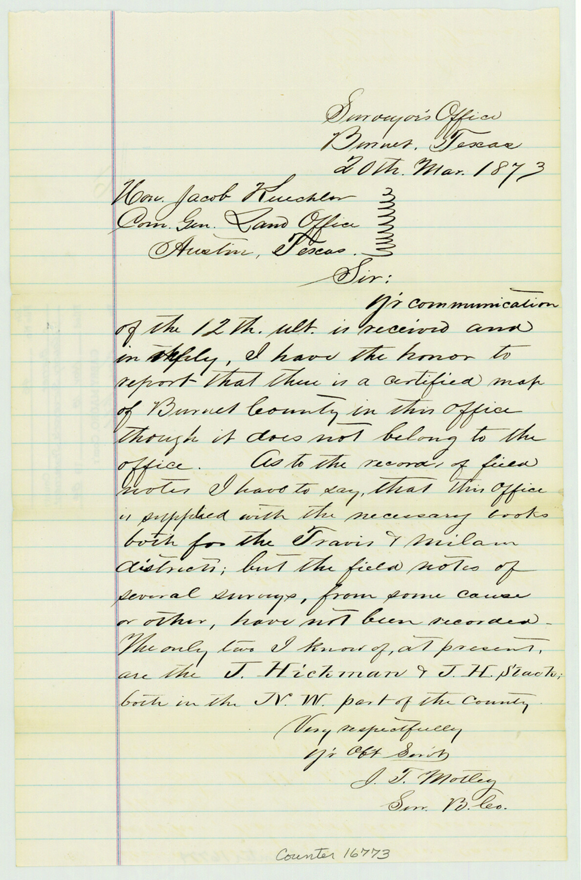
Burnet County Sketch File 46
[County Surveyor's statement regarding county records]
-
Map/Doc
16773
-
Collection
General Map Collection
-
Object Dates
1873/3/20 (Creation Date)
1984/11/18 (File Date)
-
People and Organizations
J.T. Motley (Surveyor/Engineer)
-
Counties
Burnet
-
Subjects
Surveying Sketch File
-
Height x Width
12.8 x 8.5 inches
32.5 x 21.6 cm
-
Medium
paper, manuscript
Part of: General Map Collection
Flight Mission No. BRA-8M, Frame 146, Jefferson County

Print $20.00
- Digital $50.00
Flight Mission No. BRA-8M, Frame 146, Jefferson County
1953
Size 16.0 x 16.1 inches
Map/Doc 85638
Calhoun County Boundary File 5

Print $10.00
- Digital $50.00
Calhoun County Boundary File 5
Size 14.2 x 8.8 inches
Map/Doc 51009
Real County Working Sketch 27

Print $20.00
- Digital $50.00
Real County Working Sketch 27
1947
Size 29.8 x 29.2 inches
Map/Doc 71919
Plat of a survey on Padre Island in Cameron County surveyed for South Padre Development Corporation by Claunch and Associates

Print $40.00
- Digital $50.00
Plat of a survey on Padre Island in Cameron County surveyed for South Padre Development Corporation by Claunch and Associates
1971
Size 68.7 x 42.8 inches
Map/Doc 61428
Flight Mission No. BQY-4M, Frame 55, Harris County

Print $20.00
- Digital $50.00
Flight Mission No. BQY-4M, Frame 55, Harris County
1953
Size 18.5 x 22.3 inches
Map/Doc 85264
Harris County Sketch File 75

Print $4.00
- Digital $50.00
Harris County Sketch File 75
1948
Size 11.7 x 9.0 inches
Map/Doc 25544
Orange County Rolled Sketch CR

Print $20.00
- Digital $50.00
Orange County Rolled Sketch CR
Size 39.4 x 31.5 inches
Map/Doc 9653
Jeff Davis County Working Sketch 9

Print $20.00
- Digital $50.00
Jeff Davis County Working Sketch 9
1943
Size 28.5 x 27.3 inches
Map/Doc 66504
Atascosa County Working Sketch 24

Print $20.00
- Digital $50.00
Atascosa County Working Sketch 24
1958
Size 34.0 x 43.1 inches
Map/Doc 67220
Flight Mission No. BQR-22K, Frame 34, Brazoria County

Print $20.00
- Digital $50.00
Flight Mission No. BQR-22K, Frame 34, Brazoria County
1953
Size 18.7 x 22.5 inches
Map/Doc 84118
Duval County Sketch File 4d

Print $4.00
- Digital $50.00
Duval County Sketch File 4d
1874
Size 10.8 x 8.7 inches
Map/Doc 21288
Flight Mission No. DAH-17M, Frame 31, Orange County

Print $20.00
- Digital $50.00
Flight Mission No. DAH-17M, Frame 31, Orange County
1953
Size 18.7 x 22.5 inches
Map/Doc 86894
You may also like
Menard County Boundary File 10

Print $4.00
- Digital $50.00
Menard County Boundary File 10
Size 14.2 x 8.7 inches
Map/Doc 57096
Hamilton County Sketch File 10

Print $24.00
- Digital $50.00
Hamilton County Sketch File 10
1874
Size 12.8 x 8.5 inches
Map/Doc 24919
Trinity County

Print $20.00
- Digital $50.00
Trinity County
1882
Size 17.1 x 24.6 inches
Map/Doc 4097
A Topographical Map of the Government Tract adjoining the City of Austin

Print $20.00
- Digital $50.00
A Topographical Map of the Government Tract adjoining the City of Austin
1840
Size 41.9 x 37.8 inches
Map/Doc 2180
Wise County Sketch File 29

Print $20.00
- Digital $50.00
Wise County Sketch File 29
1857
Size 11.1 x 20.7 inches
Map/Doc 76762
Sterling County Rolled Sketch 8

Print $20.00
- Digital $50.00
Sterling County Rolled Sketch 8
1884
Size 27.9 x 31.9 inches
Map/Doc 7844
Yoakum County

Print $20.00
- Digital $50.00
Yoakum County
1902
Size 46.1 x 36.6 inches
Map/Doc 63138
Jack County Sketch File 26

Print $4.00
- Digital $50.00
Jack County Sketch File 26
1891
Size 8.7 x 9.3 inches
Map/Doc 27563
Map of Winkler County

Print $20.00
- Digital $50.00
Map of Winkler County
1900
Size 42.4 x 38.6 inches
Map/Doc 16931
Floyd County Sketch File 10

Print $12.00
- Digital $50.00
Floyd County Sketch File 10
1912
Size 11.6 x 8.9 inches
Map/Doc 22701
Pecos County Working Sketch 63

Print $20.00
- Digital $50.00
Pecos County Working Sketch 63
1954
Size 29.5 x 33.2 inches
Map/Doc 71535
El Paso County Rolled Sketch 52

Print $20.00
- Digital $50.00
El Paso County Rolled Sketch 52
1929
Size 18.4 x 24.4 inches
Map/Doc 5844