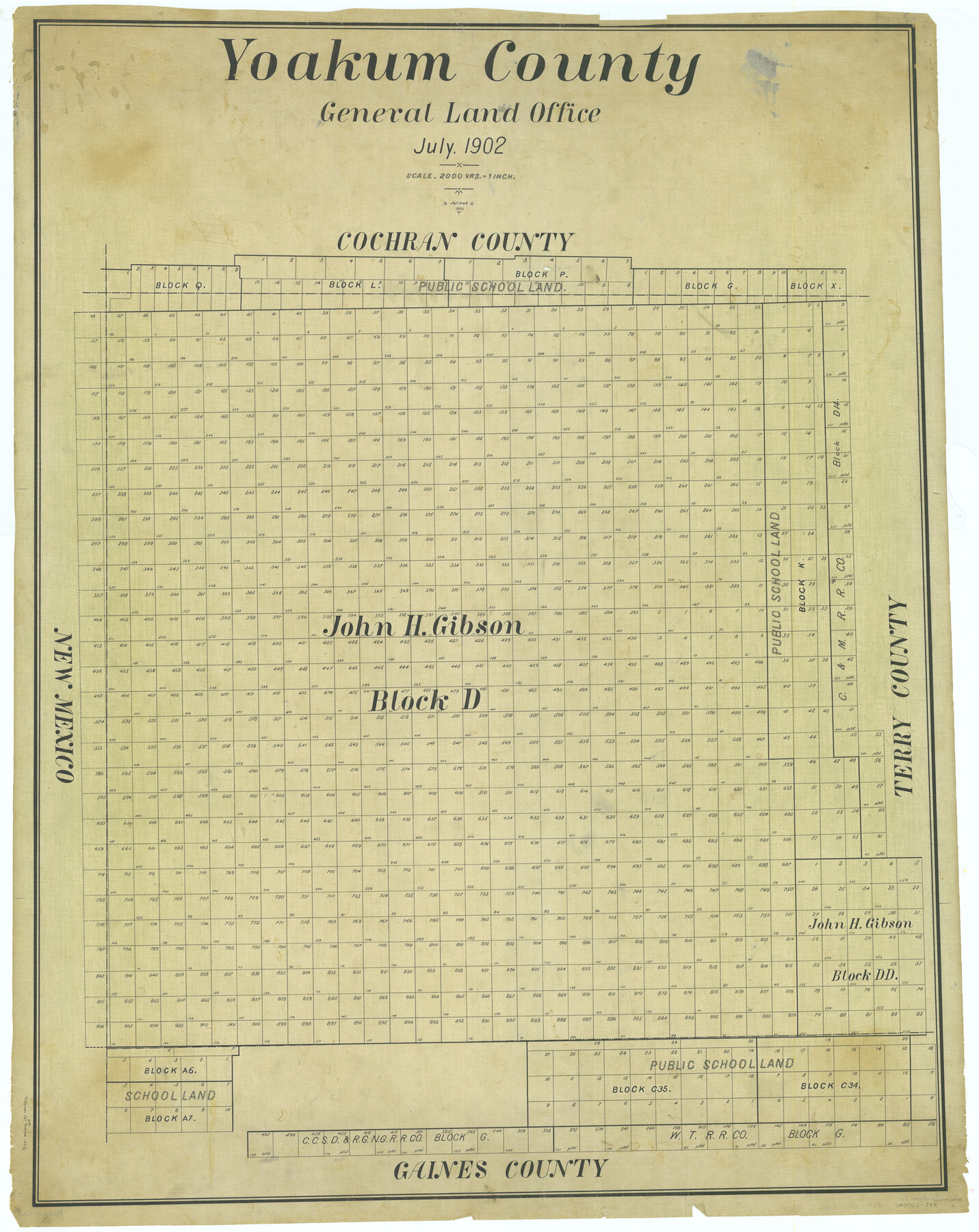
Yoakum County
-
Map/Doc
63138
-
Collection
General Map Collection
-
Object Dates
1902 (Creation Date)
-
People and Organizations
Texas General Land Office (Publisher)
-
Counties
Yoakum
-
Subjects
County
-
Height x Width
46.1 x 36.6 inches
117.1 x 93.0 cm
-
Comments
Traced in 1903 by Jelinek.
Part of: General Map Collection
[Sketch for Mineral Application 21493 - Clay County]
![65625, [Sketch for Mineral Application 21493 - Clay County], General Map Collection](https://historictexasmaps.com/wmedia_w700/maps/65625-1.tif.jpg)
Print $40.00
- Digital $50.00
[Sketch for Mineral Application 21493 - Clay County]
Size 62.4 x 34.8 inches
Map/Doc 65625
Reagan County Working Sketch 11

Print $20.00
- Digital $50.00
Reagan County Working Sketch 11
1943
Size 19.4 x 20.9 inches
Map/Doc 71851
Schleicher County Rolled Sketch 17

Print $20.00
- Digital $50.00
Schleicher County Rolled Sketch 17
Size 27.9 x 20.6 inches
Map/Doc 7759
Angelina County Rolled Sketch 2

Print $20.00
- Digital $50.00
Angelina County Rolled Sketch 2
1948
Size 21.9 x 20.1 inches
Map/Doc 77185
Hemphill County Rolled Sketch 17

Print $40.00
- Digital $50.00
Hemphill County Rolled Sketch 17
1965
Size 24.0 x 64.1 inches
Map/Doc 9157
El Paso County Working Sketch 11

Print $40.00
- Digital $50.00
El Paso County Working Sketch 11
1955
Size 49.2 x 43.4 inches
Map/Doc 69033
Real County Working Sketch 33

Print $40.00
- Digital $50.00
Real County Working Sketch 33
1948
Size 61.0 x 37.7 inches
Map/Doc 71925
McMullen County Working Sketch 13

Print $20.00
- Digital $50.00
McMullen County Working Sketch 13
1938
Size 27.2 x 21.6 inches
Map/Doc 70714
Dimmit County Sketch File 50

Print $36.00
- Digital $50.00
Dimmit County Sketch File 50
1909
Size 18.2 x 20.4 inches
Map/Doc 21181
Jim Hogg County Rolled Sketch 3

Print $20.00
- Digital $50.00
Jim Hogg County Rolled Sketch 3
1912
Size 28.2 x 20.2 inches
Map/Doc 6439
Reagan County Boundary File 1d

Print $36.00
- Digital $50.00
Reagan County Boundary File 1d
Size 9.2 x 8.3 inches
Map/Doc 58181
Runnels County Boundary File 1

Print $42.00
- Digital $50.00
Runnels County Boundary File 1
Size 9.3 x 7.7 inches
Map/Doc 58504
You may also like

Mason County Working Sketch 6

Print $20.00
- Digital $50.00
Mason County Working Sketch 6
1940
Size 17.9 x 11.1 inches
Map/Doc 70842
Crane County Working Sketch 16

Print $20.00
- Digital $50.00
Crane County Working Sketch 16
1955
Size 42.8 x 22.0 inches
Map/Doc 68293
Moore County Rolled Sketch 6

Print $20.00
- Digital $50.00
Moore County Rolled Sketch 6
1911
Size 33.4 x 30.2 inches
Map/Doc 6825
Harris County Rolled Sketch 88

Print $20.00
- Digital $50.00
Harris County Rolled Sketch 88
1935
Size 34.4 x 23.0 inches
Map/Doc 6121
Origins of Imports and Destination of Exports at Houston, Tex., during 1921

Print $20.00
- Digital $50.00
Origins of Imports and Destination of Exports at Houston, Tex., during 1921
1921
Size 14.2 x 23.1 inches
Map/Doc 97171
Leon County Rolled Sketch 33

Print $20.00
- Digital $50.00
Leon County Rolled Sketch 33
1997
Size 26.3 x 36.7 inches
Map/Doc 6617
Edwards County Working Sketch 107

Print $40.00
- Digital $50.00
Edwards County Working Sketch 107
1972
Size 54.5 x 38.8 inches
Map/Doc 68983
Hale County Sketch File 18

Print $4.00
- Digital $50.00
Hale County Sketch File 18
1903
Size 11.0 x 8.6 inches
Map/Doc 24749
General Highway Map, Jeff Davis County, Texas

Print $20.00
General Highway Map, Jeff Davis County, Texas
1961
Size 18.3 x 24.6 inches
Map/Doc 79536
Reconnaissance Map, Roby Sheet

Print $20.00
- Digital $50.00
Reconnaissance Map, Roby Sheet
1893
Size 17.0 x 20.8 inches
Map/Doc 90869
