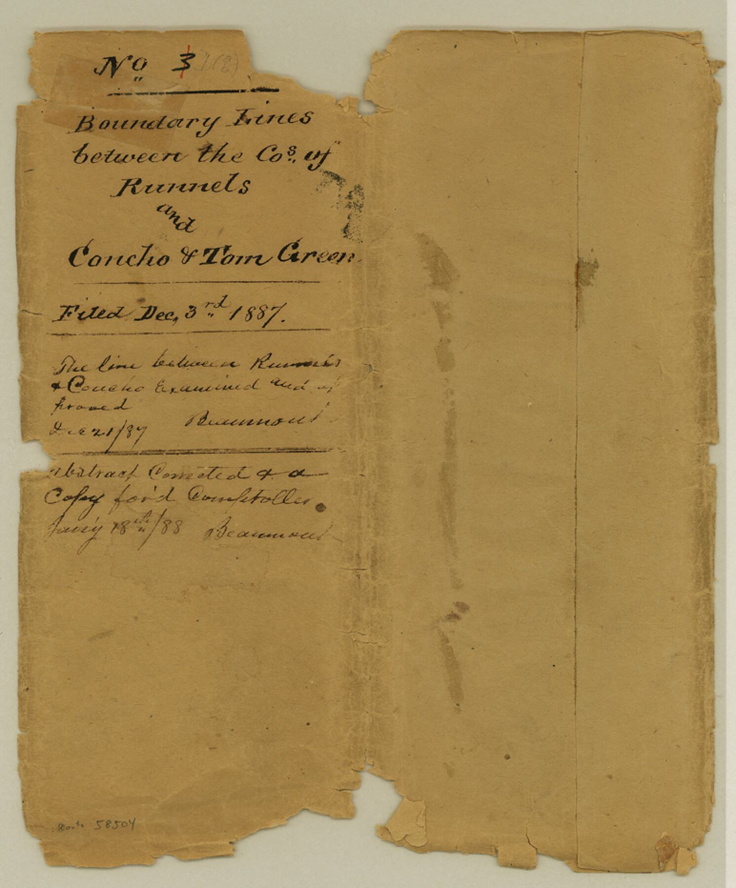
Runnels County Boundary File 1
B'd'y line between Runnels and Tom Green Co.
-
Map/Doc
58504
-
Collection
General Map Collection
-
Counties
Runnels
-
Subjects
County Boundaries
-
Height x Width
9.3 x 7.7 inches
23.6 x 19.6 cm
Part of: General Map Collection
Brown County Sketch File 15

Print $4.00
- Digital $50.00
Brown County Sketch File 15
1857
Size 12.2 x 8.0 inches
Map/Doc 16610
Uvalde County Sketch File 28

Print $10.00
- Digital $50.00
Uvalde County Sketch File 28
1980
Size 14.8 x 8.9 inches
Map/Doc 39023
Brewster County Rolled Sketch 59CC

Print $20.00
- Digital $50.00
Brewster County Rolled Sketch 59CC
1939
Size 18.3 x 24.9 inches
Map/Doc 5230
Zapata County Working Sketch 24

Print $20.00
- Digital $50.00
Zapata County Working Sketch 24
1992
Size 28.2 x 23.9 inches
Map/Doc 62075
Guadalupe County Sketch File 4

Print $4.00
- Digital $50.00
Guadalupe County Sketch File 4
1869
Size 8.2 x 7.9 inches
Map/Doc 24654
Liberty County Sketch File 13

Print $12.00
- Digital $50.00
Liberty County Sketch File 13
1858
Size 8.3 x 7.9 inches
Map/Doc 29909
Reeves County Rolled Sketch 17

Print $20.00
- Digital $50.00
Reeves County Rolled Sketch 17
1963
Size 28.4 x 36.1 inches
Map/Doc 7486
Erath County Working Sketch 50a

Print $20.00
- Digital $50.00
Erath County Working Sketch 50a
Size 43.2 x 37.0 inches
Map/Doc 69131
Childress County Working Sketch 2

Print $20.00
- Digital $50.00
Childress County Working Sketch 2
1907
Size 17.1 x 14.9 inches
Map/Doc 68018
La Salle County Sketch File 28a

Print $6.00
- Digital $50.00
La Salle County Sketch File 28a
1898
Size 4.5 x 5.2 inches
Map/Doc 29558
Goliad County

Print $20.00
- Digital $50.00
Goliad County
1946
Size 44.0 x 46.1 inches
Map/Doc 95509
San Patricio County Rolled Sketch 29

Print $20.00
- Digital $50.00
San Patricio County Rolled Sketch 29
Size 39.2 x 45.5 inches
Map/Doc 9893
You may also like
Flight Mission No. BQR-20K, Frame 13, Brazoria County

Print $20.00
- Digital $50.00
Flight Mission No. BQR-20K, Frame 13, Brazoria County
1952
Size 18.6 x 22.3 inches
Map/Doc 84115
Washington County Sketch File 3

Print $4.00
- Digital $50.00
Washington County Sketch File 3
1860
Size 8.1 x 9.2 inches
Map/Doc 39648
Texas Gulf Coast Map from the Sabine River to the Rio Grande as subdivided for mineral development

Print $20.00
- Digital $50.00
Texas Gulf Coast Map from the Sabine River to the Rio Grande as subdivided for mineral development
1948
Size 41.6 x 39.2 inches
Map/Doc 2904
Galveston County Sketch File 28

Print $42.00
- Digital $50.00
Galveston County Sketch File 28
1913
Size 22.2 x 5.4 inches
Map/Doc 23410
University Lands Blocks 29-33, Crockett County, Texas

Print $20.00
- Digital $50.00
University Lands Blocks 29-33, Crockett County, Texas
1936
Size 29.2 x 42.4 inches
Map/Doc 2407
General Highway Map, San Augustine County, Texas

Print $20.00
General Highway Map, San Augustine County, Texas
1961
Size 24.6 x 18.1 inches
Map/Doc 79645
Wood County Sketch File 10

Print $12.00
- Digital $50.00
Wood County Sketch File 10
1850
Size 8.3 x 12.8 inches
Map/Doc 40658
Map of the United States and Territories to accompany annual report of Hon. N.C. McFarland, Commissioner, General Land Office for fiscal year which ended June 30, 1884

Print $20.00
- Digital $50.00
Map of the United States and Territories to accompany annual report of Hon. N.C. McFarland, Commissioner, General Land Office for fiscal year which ended June 30, 1884
1884
Size 27.0 x 39.3 inches
Map/Doc 96631
Hopkins County Sketch File 8

Print $6.00
- Digital $50.00
Hopkins County Sketch File 8
1856
Size 11.8 x 8.6 inches
Map/Doc 26695
1882 Map of the Texas & Pacific R-Y Reserve

Print $20.00
- Digital $50.00
1882 Map of the Texas & Pacific R-Y Reserve
1887
Size 44.5 x 31.7 inches
Map/Doc 83559
Pecos County Working Sketch 102

Print $40.00
- Digital $50.00
Pecos County Working Sketch 102
1971
Size 36.9 x 52.7 inches
Map/Doc 71575
Galveston County Sketch File 68

Print $62.00
- Digital $50.00
Galveston County Sketch File 68
Size 4.4 x 9.7 inches
Map/Doc 23784