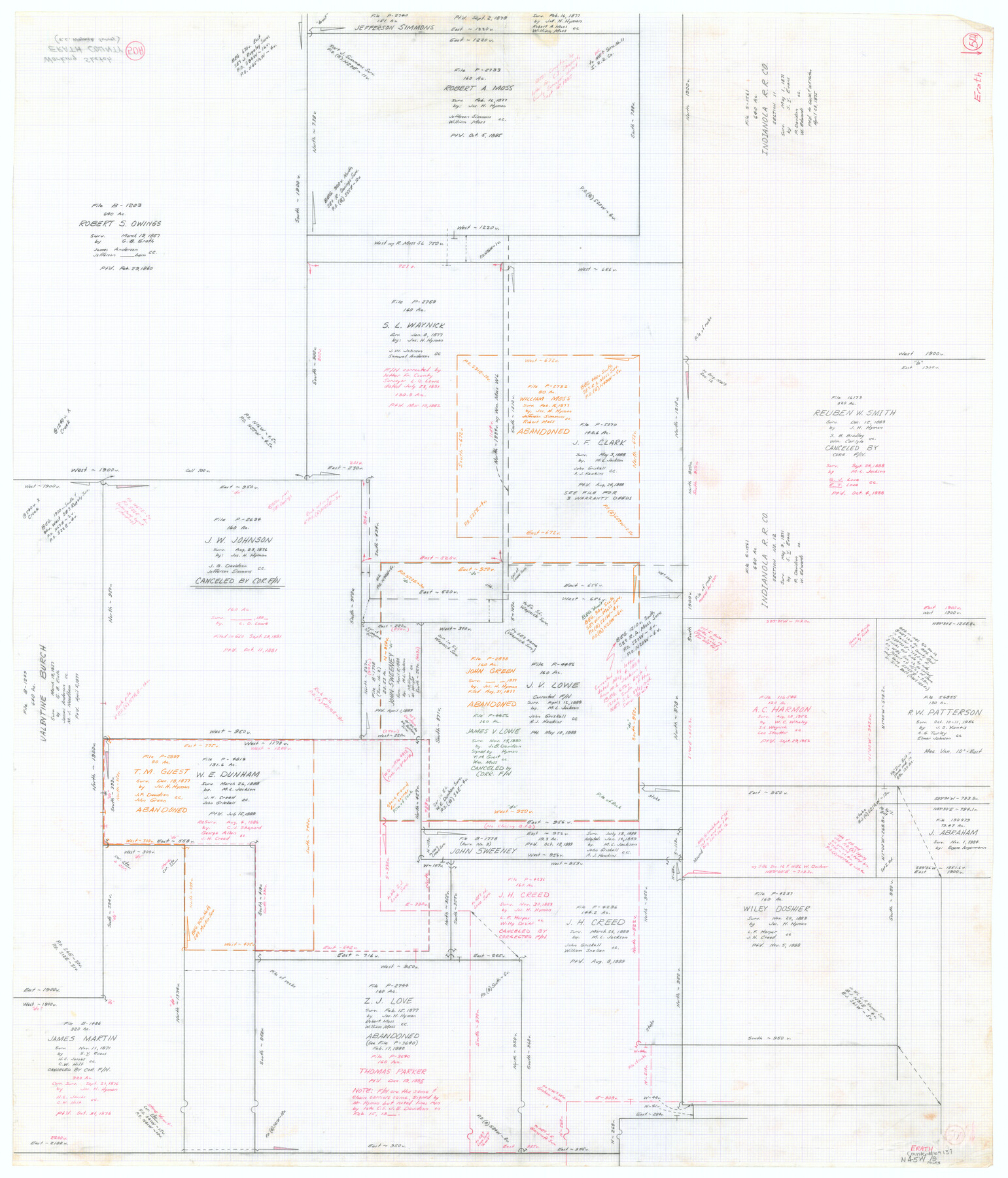
Erath County Working Sketch 50a
-
Map/Doc
69131
-
Collection
General Map Collection
-
Counties
Erath
-
Subjects
Surveying Working Sketch
-
Height x Width
43.2 x 37.0 inches
109.7 x 94.0 cm
Part of: General Map Collection
Mills County Sketch File 4

Print $4.00
- Digital $50.00
Mills County Sketch File 4
Size 8.8 x 8.3 inches
Map/Doc 31648
Intracoastal Waterway - Laguna Madre - Chubby Island to Stover Point including the Arroyo Colorado, Texas

Print $20.00
- Digital $50.00
Intracoastal Waterway - Laguna Madre - Chubby Island to Stover Point including the Arroyo Colorado, Texas
1976
Size 15.6 x 43.8 inches
Map/Doc 75900
Right of Way and Track Map International & Gt. Northern Ry. operated by the International & Gt. Northern Ry. Co., Gulf Division, Columbia Branch

Print $40.00
- Digital $50.00
Right of Way and Track Map International & Gt. Northern Ry. operated by the International & Gt. Northern Ry. Co., Gulf Division, Columbia Branch
1917
Size 25.3 x 56.7 inches
Map/Doc 64601
Uvalde County Sketch File 11

Print $46.00
- Digital $50.00
Uvalde County Sketch File 11
1886
Size 12.1 x 13.1 inches
Map/Doc 38972
Flight Mission No. DCL-4C, Frame 69, Kenedy County

Print $20.00
- Digital $50.00
Flight Mission No. DCL-4C, Frame 69, Kenedy County
1943
Size 18.7 x 22.3 inches
Map/Doc 85814
[Sketch of Col. Cooke's Military Road expedition from Red River to Austin]
![82146, [Sketch of Col. Cooke's Military Road expedition from Red River to Austin], General Map Collection](https://historictexasmaps.com/wmedia_w700/maps/82146-1.tif.jpg)
Print $20.00
- Digital $50.00
[Sketch of Col. Cooke's Military Road expedition from Red River to Austin]
Size 33.4 x 23.4 inches
Map/Doc 82146
Map of the Panhandle Railway

Print $40.00
- Digital $50.00
Map of the Panhandle Railway
1888
Size 22.6 x 114.7 inches
Map/Doc 64461
Presidio County Sketch File 104

Print $17.00
- Digital $50.00
Presidio County Sketch File 104
Size 11.3 x 8.7 inches
Map/Doc 34807
A New Map of North America

Print $20.00
- Digital $50.00
A New Map of North America
1779
Size 18.5 x 22.2 inches
Map/Doc 95141
Flight Mission No. DAG-14K, Frame 132, Matagorda County

Print $20.00
- Digital $50.00
Flight Mission No. DAG-14K, Frame 132, Matagorda County
1952
Size 17.6 x 17.5 inches
Map/Doc 86303
Tarrant County Working Sketch 24

Print $20.00
- Digital $50.00
Tarrant County Working Sketch 24
2003
Size 26.0 x 34.9 inches
Map/Doc 78642
Menard County

Print $20.00
- Digital $50.00
Menard County
1942
Size 41.2 x 43.4 inches
Map/Doc 73238
You may also like
Gray's Geological Map of the United States

Print $20.00
- Digital $50.00
Gray's Geological Map of the United States
1873
Size 17.6 x 28.8 inches
Map/Doc 95174
Loving County Working Sketch 4

Print $20.00
- Digital $50.00
Loving County Working Sketch 4
1941
Size 20.1 x 40.2 inches
Map/Doc 70636
Parker County Sketch File 6

Print $6.00
- Digital $50.00
Parker County Sketch File 6
1858
Size 6.9 x 6.0 inches
Map/Doc 33530
Chambers County Working Sketch 30

Print $20.00
- Digital $50.00
Chambers County Working Sketch 30
2012
Size 29.2 x 43.9 inches
Map/Doc 93400
The Texas and Oklahoma Official Railway & Hotel Guide Map

Print $20.00
- Digital $50.00
The Texas and Oklahoma Official Railway & Hotel Guide Map
1918
Size 23.4 x 24.0 inches
Map/Doc 95893
Webb County Rolled Sketch EF1

Print $20.00
- Digital $50.00
Webb County Rolled Sketch EF1
1931
Size 40.3 x 30.0 inches
Map/Doc 8223
Tarrant County

Print $20.00
- Digital $50.00
Tarrant County
1861
Size 17.0 x 16.4 inches
Map/Doc 4067
Smith County Sketch File 4

Print $4.00
- Digital $50.00
Smith County Sketch File 4
1853
Size 10.3 x 8.1 inches
Map/Doc 36752
United States, 1956 Revised Edition

Print $40.00
- Digital $50.00
United States, 1956 Revised Edition
1946
Size 48.0 x 36.3 inches
Map/Doc 78631
Bandera County Working Sketch 51

Print $40.00
- Digital $50.00
Bandera County Working Sketch 51
1985
Size 49.8 x 44.3 inches
Map/Doc 67647
Wise County Working Sketch 26

Print $20.00
- Digital $50.00
Wise County Working Sketch 26
1987
Size 25.8 x 33.7 inches
Map/Doc 72640
Township 2 South Range 12 West, South Western District, Louisiana

Print $20.00
- Digital $50.00
Township 2 South Range 12 West, South Western District, Louisiana
1884
Size 19.7 x 24.7 inches
Map/Doc 65882