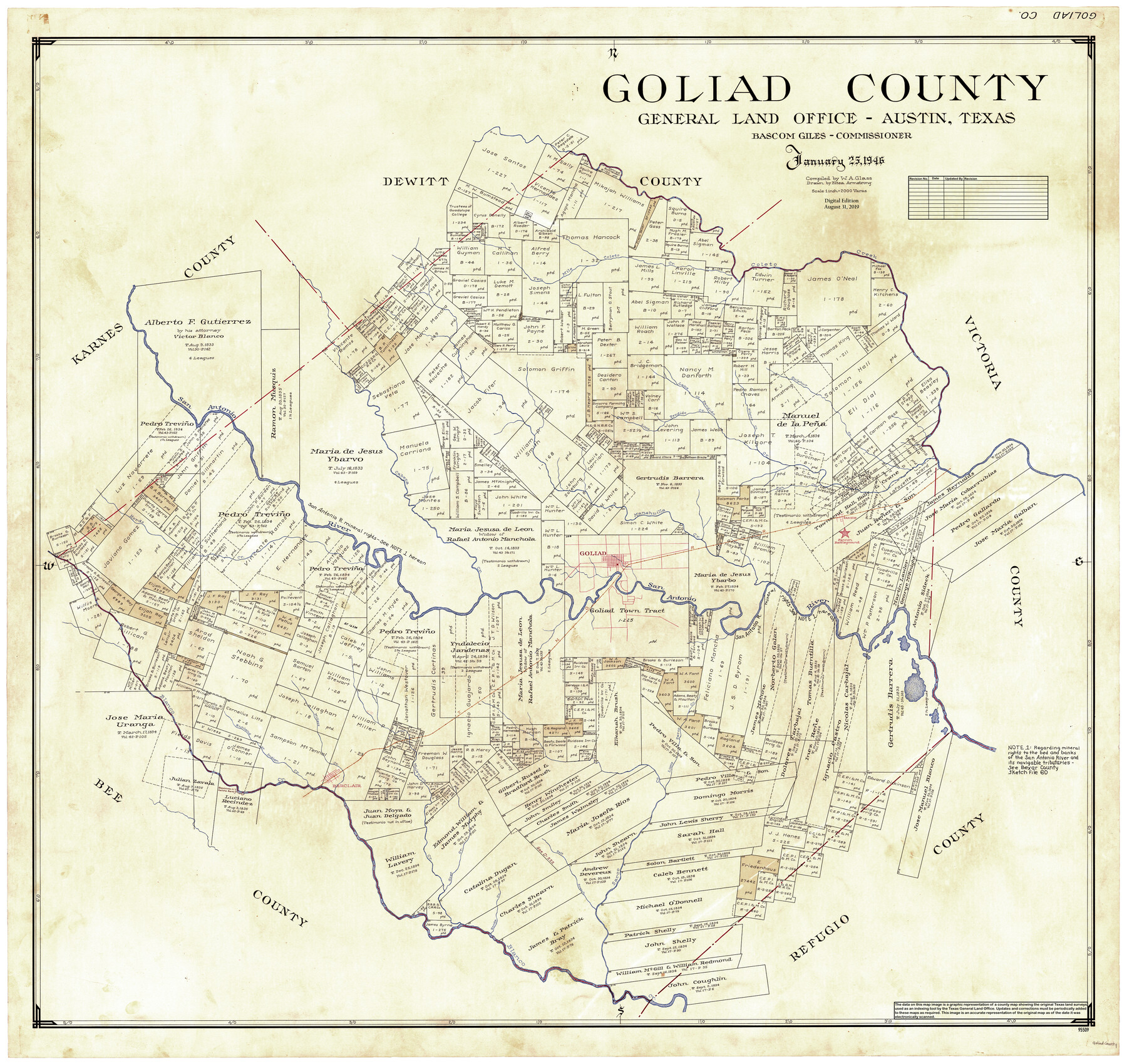
Goliad County
General Land Office Official County Map
-
Map/Doc
95509
-
Collection
General Map Collection
-
Object Dates
1946/1/25 (Creation Date)
2019/8/31 (Revision Date)
-
People and Organizations
W.A. Glass (Compiler)
Eltea Armstrong (Draftsman)
Cheyenne Betancourt (Draftsman)
Bascom Giles (GLO Commissioner)
-
Counties
Goliad
-
Subjects
County OCM
-
Height x Width
44.0 x 46.1 inches
111.8 x 117.1 cm
-
Medium
digital image
-
Scale
1" = 2000 varas
Part of: General Map Collection
Flight Mission No. BRE-4P, Frame 172, Nueces County

Print $20.00
- Digital $50.00
Flight Mission No. BRE-4P, Frame 172, Nueces County
1956
Size 18.4 x 22.1 inches
Map/Doc 86835
Surveys made on La Parita, March 1847

Print $2.00
- Digital $50.00
Surveys made on La Parita, March 1847
1847
Size 10.1 x 7.5 inches
Map/Doc 222
Oldham County Rolled Sketch 7

Print $20.00
- Digital $50.00
Oldham County Rolled Sketch 7
Size 36.2 x 27.5 inches
Map/Doc 7173
Flight Mission No. BRE-2P, Frame 22, Nueces County

Print $20.00
- Digital $50.00
Flight Mission No. BRE-2P, Frame 22, Nueces County
1956
Size 18.7 x 22.6 inches
Map/Doc 86731
Flight Mission No. BRE-1P, Frame 119, Nueces County

Print $20.00
- Digital $50.00
Flight Mission No. BRE-1P, Frame 119, Nueces County
1956
Size 18.7 x 22.7 inches
Map/Doc 86685
Trinity River, Cooks Ferry Sheet

Print $40.00
- Digital $50.00
Trinity River, Cooks Ferry Sheet
1926
Size 36.5 x 56.2 inches
Map/Doc 65215
Gregg County Sketch File 6

Print $10.00
- Digital $50.00
Gregg County Sketch File 6
1931
Size 11.2 x 8.8 inches
Map/Doc 24577
Coke County Working Sketch 24

Print $20.00
- Digital $50.00
Coke County Working Sketch 24
1956
Size 28.7 x 31.1 inches
Map/Doc 68061
Ward County Sketch File 8

Print $20.00
- Digital $50.00
Ward County Sketch File 8
Size 13.3 x 22.8 inches
Map/Doc 12599
Coleman County Sketch File 16

Print $4.00
- Digital $50.00
Coleman County Sketch File 16
1849
Size 9.6 x 8.3 inches
Map/Doc 18683
Pecos County Working Sketch 141

Print $20.00
- Digital $50.00
Pecos County Working Sketch 141
1941
Size 31.8 x 42.5 inches
Map/Doc 9733
Flight Mission No. CUG-3P, Frame 40, Kleberg County

Print $20.00
- Digital $50.00
Flight Mission No. CUG-3P, Frame 40, Kleberg County
1956
Size 18.5 x 22.2 inches
Map/Doc 86245
You may also like
Cass County Working Sketch 26

Print $20.00
- Digital $50.00
Cass County Working Sketch 26
1974
Size 32.1 x 28.9 inches
Map/Doc 67929
Mitchell County Working Sketch 8

Print $20.00
- Digital $50.00
Mitchell County Working Sketch 8
1975
Size 31.9 x 26.3 inches
Map/Doc 71065
Crosby County Boundary File 2

Print $64.00
- Digital $50.00
Crosby County Boundary File 2
Size 42.8 x 7.0 inches
Map/Doc 51997
[Blocks C31, C32, C36-C39]
![91867, [Blocks C31, C32, C36-C39], Twichell Survey Records](https://historictexasmaps.com/wmedia_w700/maps/91867-1.tif.jpg)
Print $20.00
- Digital $50.00
[Blocks C31, C32, C36-C39]
Size 15.6 x 16.0 inches
Map/Doc 91867
Hutchinson County Rolled Sketch 44-5

Print $20.00
- Digital $50.00
Hutchinson County Rolled Sketch 44-5
2002
Size 24.0 x 36.0 inches
Map/Doc 77541
Map of part of Presidio Co. Texas

Print $20.00
- Digital $50.00
Map of part of Presidio Co. Texas
Size 16.5 x 21.3 inches
Map/Doc 75769
[Plat map of Provident City and surrounding] / Map showing the Gulf Coast Country and Railways and Water Shipping Facilities of the Provident Land Tract
![95819, [Plat map of Provident City and surrounding] / Map showing the Gulf Coast Country and Railways and Water Shipping Facilities of the Provident Land Tract, Cobb Digital Map Collection](https://historictexasmaps.com/wmedia_w700/maps/95819.tif.jpg)
Print $20.00
- Digital $50.00
[Plat map of Provident City and surrounding] / Map showing the Gulf Coast Country and Railways and Water Shipping Facilities of the Provident Land Tract
1908
Size 22.0 x 22.9 inches
Map/Doc 95819
Cameron County Rolled Sketch 25

Print $20.00
- Digital $50.00
Cameron County Rolled Sketch 25
1977
Size 24.5 x 30.4 inches
Map/Doc 5793
Sherman County Sketch File C

Print $54.00
- Digital $50.00
Sherman County Sketch File C
1918
Size 11.4 x 8.8 inches
Map/Doc 36694
Travis County Rolled Sketch 34

Print $20.00
- Digital $50.00
Travis County Rolled Sketch 34
1949
Size 22.9 x 25.2 inches
Map/Doc 8035

Rusk County Sketch File 44

Print $12.00
Rusk County Sketch File 44
1951
Size 11.3 x 8.9 inches
Map/Doc 35585