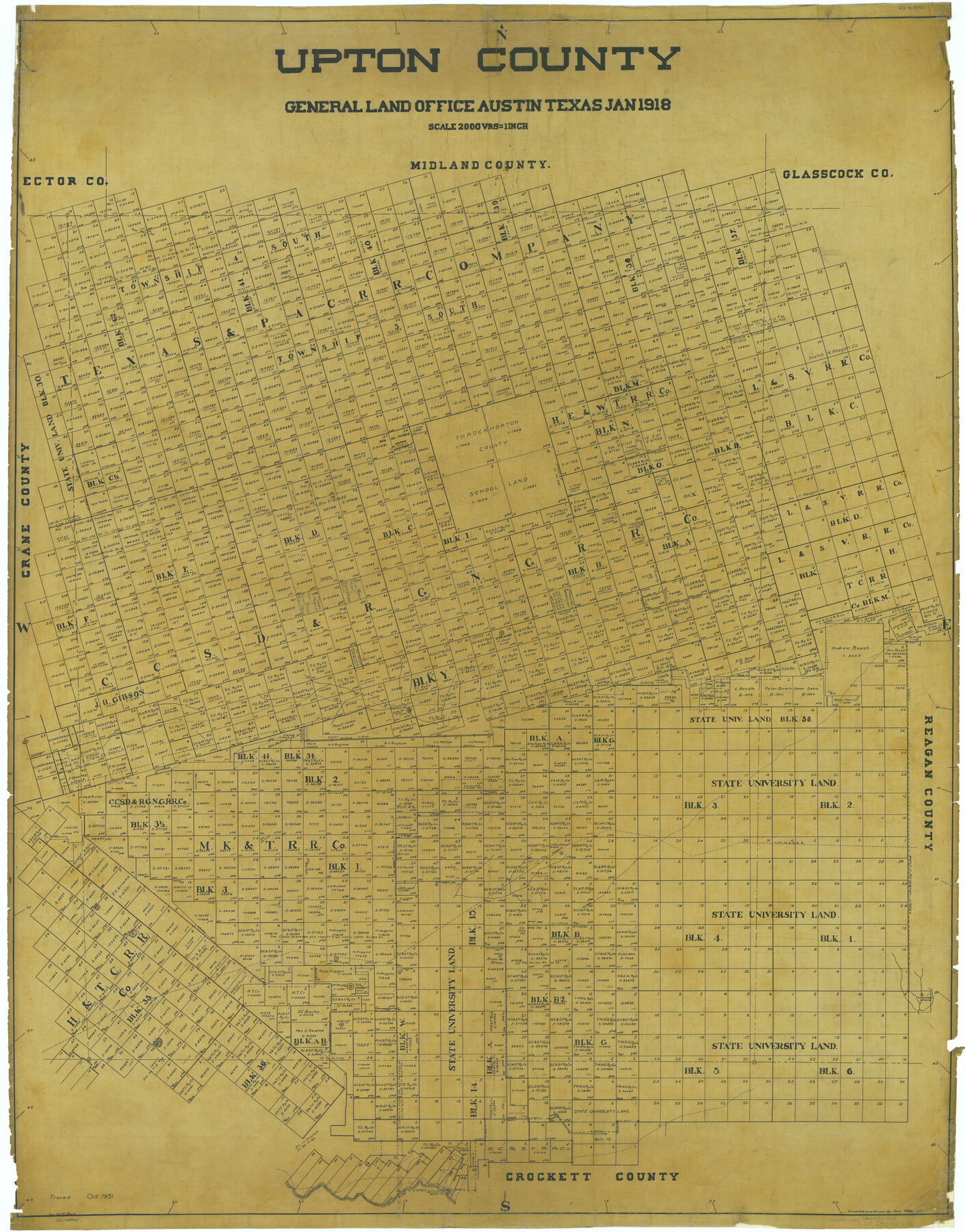
Upton County
-
Map/Doc
63089
-
Collection
General Map Collection
-
Object Dates
1918 (Creation Date)
-
People and Organizations
Texas General Land Office (Publisher)
Tom G. Atlee (Draftsman)
Tom G. Atlee (Compiler)
-
Counties
Upton
-
Subjects
County
-
Height x Width
53.9 x 42.2 inches
136.9 x 107.2 cm
-
Comments
Traced in October 1931 by W. M. Beck.
Part of: General Map Collection
Edwards County Working Sketch 9

Print $20.00
- Digital $50.00
Edwards County Working Sketch 9
1920
Size 22.2 x 34.7 inches
Map/Doc 68885
Starr County Working Sketch 16

Print $20.00
- Digital $50.00
Starr County Working Sketch 16
1981
Size 21.5 x 12.0 inches
Map/Doc 63932
Foard County Sketch File 25

Print $8.00
- Digital $50.00
Foard County Sketch File 25
1885
Size 12.9 x 8.5 inches
Map/Doc 22852

Brazoria County NRC Article 33.136 Sketch 28

Print $24.00
Brazoria County NRC Article 33.136 Sketch 28
2025
Map/Doc 97473
Bexar County Sketch File 50

Print $40.00
- Digital $50.00
Bexar County Sketch File 50
1874
Size 22.5 x 18.2 inches
Map/Doc 10926
Caldwell County Working Sketch 10

Print $40.00
- Digital $50.00
Caldwell County Working Sketch 10
1977
Size 46.2 x 50.5 inches
Map/Doc 67840
Cottle County Working Sketch 18

Print $20.00
- Digital $50.00
Cottle County Working Sketch 18
1977
Size 32.2 x 41.3 inches
Map/Doc 68328
La Salle County Rolled Sketch 7

Print $40.00
- Digital $50.00
La Salle County Rolled Sketch 7
Size 38.7 x 48.0 inches
Map/Doc 10652
Harris County Working Sketch 80

Print $20.00
- Digital $50.00
Harris County Working Sketch 80
1968
Size 35.8 x 29.9 inches
Map/Doc 65972
Archer County Sketch File 6

Print $4.00
- Digital $50.00
Archer County Sketch File 6
Size 7.2 x 8.4 inches
Map/Doc 13634
Flight Mission No. DAG-21K, Frame 30, Matagorda County

Print $20.00
- Digital $50.00
Flight Mission No. DAG-21K, Frame 30, Matagorda County
1952
Size 18.5 x 22.4 inches
Map/Doc 86397
You may also like
[Sketch for Mineral Application 17237 / Mineral File 11855 - Neches River, Joe A. Sanders]
![2819, [Sketch for Mineral Application 17237 / Mineral File 11855 - Neches River, Joe A. Sanders], General Map Collection](https://historictexasmaps.com/wmedia_w700/maps/2819.tif.jpg)
Print $2.00
- Digital $50.00
[Sketch for Mineral Application 17237 / Mineral File 11855 - Neches River, Joe A. Sanders]
1927
Size 12.8 x 8.2 inches
Map/Doc 2819
Map of the post of Fort Brown, Brownsville, Texas

Print $20.00
Map of the post of Fort Brown, Brownsville, Texas
1877
Size 24.0 x 33.9 inches
Map/Doc 93560
Brewster County Working Sketch 58

Print $20.00
- Digital $50.00
Brewster County Working Sketch 58
1955
Size 19.8 x 21.7 inches
Map/Doc 67659
Sutton County Rolled Sketch 59

Print $40.00
- Digital $50.00
Sutton County Rolled Sketch 59
1960
Size 86.1 x 42.5 inches
Map/Doc 9977
The Republic County of San Patricio. December 31, 1838

Print $20.00
The Republic County of San Patricio. December 31, 1838
2020
Size 22.2 x 21.7 inches
Map/Doc 96275
Clayton Carter Addition, North 84.9 Acres of Section 77, Block A

Print $20.00
- Digital $50.00
Clayton Carter Addition, North 84.9 Acres of Section 77, Block A
1945
Size 30.1 x 9.6 inches
Map/Doc 92767
Sutton County Rolled Sketch 68

Print $20.00
- Digital $50.00
Sutton County Rolled Sketch 68
Size 31.0 x 37.4 inches
Map/Doc 9980
Henderson County Sketch File 4

Print $4.00
- Digital $50.00
Henderson County Sketch File 4
1851
Size 12.9 x 8.3 inches
Map/Doc 26323
Portion of States Submerged Area in Matagorda Bay

Print $20.00
- Digital $50.00
Portion of States Submerged Area in Matagorda Bay
1922
Size 14.0 x 12.5 inches
Map/Doc 2955
Kinney County Rolled Sketch 15

Print $20.00
- Digital $50.00
Kinney County Rolled Sketch 15
Size 28.2 x 43.4 inches
Map/Doc 9354
Haskell County Boundary File 3

Print $6.00
- Digital $50.00
Haskell County Boundary File 3
Size 11.0 x 8.6 inches
Map/Doc 54539
Map of Fort Bend Co.

Print $20.00
- Digital $50.00
Map of Fort Bend Co.
1898
Size 45.1 x 41.1 inches
Map/Doc 75965