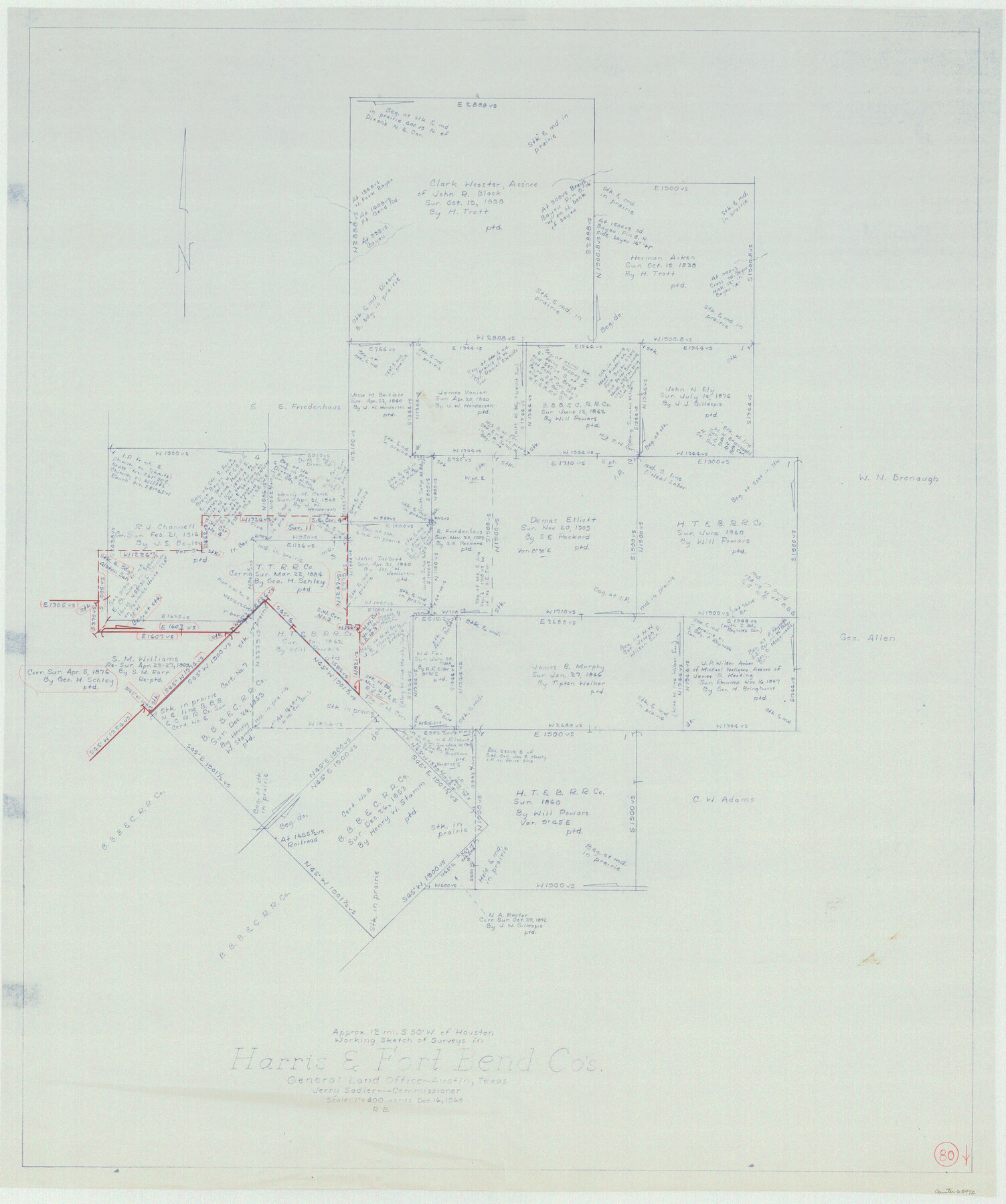
Harris County Working Sketch 80
-
Map/Doc
65972
-
Collection
General Map Collection
-
Object Dates
12/16/1968 (Creation Date)
-
People and Organizations
Roy Buckholts (Draftsman)
-
Counties
Harris Fort Bend
-
Subjects
Surveying Working Sketch
-
Height x Width
35.8 x 29.9 inches
90.9 x 76.0 cm
-
Scale
1" = 400 varas
Part of: General Map Collection
Flight Mission No. DAG-21K, Frame 96, Matagorda County

Print $20.00
- Digital $50.00
Flight Mission No. DAG-21K, Frame 96, Matagorda County
1952
Size 18.4 x 22.4 inches
Map/Doc 86425
Flight Mission No. DQO-2K, Frame 87, Galveston County

Print $20.00
- Digital $50.00
Flight Mission No. DQO-2K, Frame 87, Galveston County
1952
Size 18.7 x 22.5 inches
Map/Doc 85014
Bailey County Sketch File 3a

Print $12.00
- Digital $50.00
Bailey County Sketch File 3a
1901
Size 8.1 x 9.0 inches
Map/Doc 13948
Upshur County Working Sketch 18

Print $20.00
- Digital $50.00
Upshur County Working Sketch 18
1998
Size 18.1 x 27.7 inches
Map/Doc 69576
Map of Armstrong Co.

Print $20.00
- Digital $50.00
Map of Armstrong Co.
1897
Size 38.2 x 34.8 inches
Map/Doc 3246
Victoria County Rolled Sketch 1

Print $20.00
- Digital $50.00
Victoria County Rolled Sketch 1
1902
Size 20.5 x 17.5 inches
Map/Doc 8150
Travis County Sketch File 52

Print $8.00
- Digital $50.00
Travis County Sketch File 52
1942
Size 14.4 x 8.9 inches
Map/Doc 38391
Hidalgo County Working Sketch 6

Print $20.00
- Digital $50.00
Hidalgo County Working Sketch 6
1960
Size 21.4 x 20.4 inches
Map/Doc 66183
[Surveys along the Lavaca River]
![25, [Surveys along the Lavaca River], General Map Collection](https://historictexasmaps.com/wmedia_w700/maps/25.tif.jpg)
Print $2.00
- Digital $50.00
[Surveys along the Lavaca River]
1833
Size 12.9 x 8.9 inches
Map/Doc 25
McMullen County Working Sketch 22

Print $40.00
- Digital $50.00
McMullen County Working Sketch 22
1947
Size 39.1 x 53.3 inches
Map/Doc 70723
Harris County Rolled Sketch 86

Print $20.00
- Digital $50.00
Harris County Rolled Sketch 86
1933
Size 33.5 x 32.4 inches
Map/Doc 73575
El Paso County Working Sketch 43

Print $20.00
- Digital $50.00
El Paso County Working Sketch 43
Size 22.1 x 26.1 inches
Map/Doc 69065
You may also like
Jim Hogg County Working Sketch 11

Print $20.00
- Digital $50.00
Jim Hogg County Working Sketch 11
1979
Size 24.7 x 37.6 inches
Map/Doc 66597
Flight Mission No. DCL-7C, Frame 94, Kenedy County

Print $20.00
- Digital $50.00
Flight Mission No. DCL-7C, Frame 94, Kenedy County
1943
Size 15.4 x 15.1 inches
Map/Doc 86066
Amistad International Reservoir on Rio Grande 89b

Print $20.00
- Digital $50.00
Amistad International Reservoir on Rio Grande 89b
1950
Size 28.4 x 40.7 inches
Map/Doc 75519
Bosque County, Texas

Print $20.00
- Digital $50.00
Bosque County, Texas
1879
Size 25.1 x 29.9 inches
Map/Doc 420
[Blocks L. E. and B8]
![90666, [Blocks L. E. and B8], Twichell Survey Records](https://historictexasmaps.com/wmedia_w700/maps/90666-2.tif.jpg)
Print $20.00
- Digital $50.00
[Blocks L. E. and B8]
Size 18.4 x 13.6 inches
Map/Doc 90666
Deaf Smith County Working Sketch 6

Print $20.00
- Digital $50.00
Deaf Smith County Working Sketch 6
2019
Size 36.5 x 24.5 inches
Map/Doc 95408

Atascosa County Rolled Sketch 8

Print $20.00
- Digital $50.00
Atascosa County Rolled Sketch 8
1942
Size 34.8 x 41.9 inches
Map/Doc 8427
San Jacinto County Working Sketch 23

Print $40.00
- Digital $50.00
San Jacinto County Working Sketch 23
1940
Size 31.5 x 53.8 inches
Map/Doc 63736
Map of the Southern Pacific Rail Road through Harrison County, Texas

Print $40.00
- Digital $50.00
Map of the Southern Pacific Rail Road through Harrison County, Texas
1860
Size 26.8 x 76.6 inches
Map/Doc 64140
Carson County Boundary File 10

Print $2.00
- Digital $50.00
Carson County Boundary File 10
Size 11.5 x 7.2 inches
Map/Doc 51185
Glasscock County Sketch File 3

Print $3.00
- Digital $50.00
Glasscock County Sketch File 3
1931
Size 11.1 x 14.8 inches
Map/Doc 11560