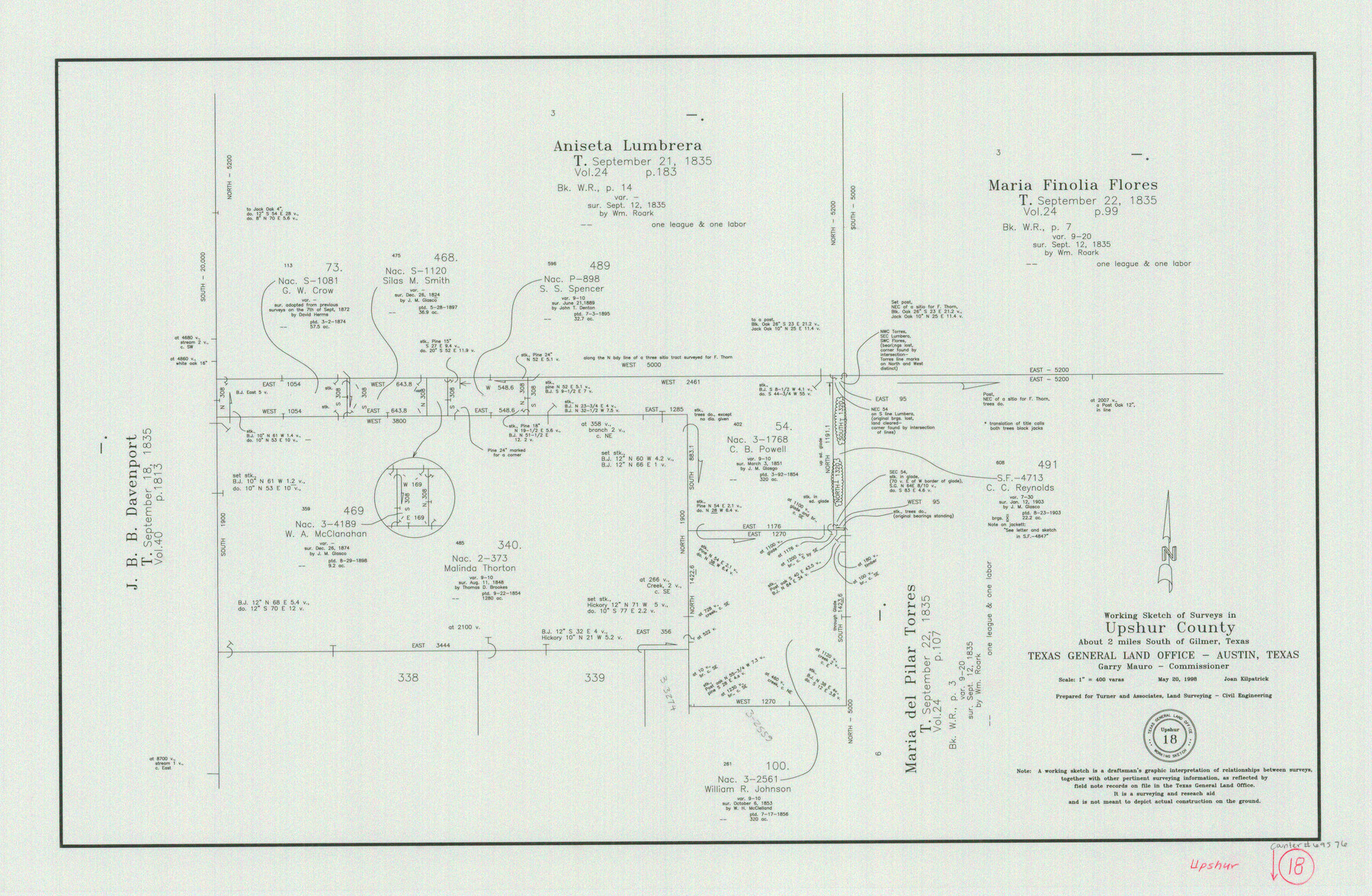
Upshur County Working Sketch 18
-
Map/Doc
69576
-
Collection
General Map Collection
-
Object Dates
5/20/1998 (Creation Date)
-
People and Organizations
Joan Kilpatrick (Draftsman)
-
Counties
Upshur
-
Subjects
Surveying Working Sketch
-
Height x Width
18.1 x 27.7 inches
46.0 x 70.4 cm
-
Scale
1" = 400 varas
Part of: General Map Collection
Flight Mission No. BRA-16M, Frame 147, Jefferson County

Print $20.00
- Digital $50.00
Flight Mission No. BRA-16M, Frame 147, Jefferson County
1953
Size 18.6 x 22.3 inches
Map/Doc 85753
Bosque County Sketch File 18

Print $4.00
- Digital $50.00
Bosque County Sketch File 18
1863
Size 13.5 x 8.4 inches
Map/Doc 14792
Flight Mission No. CON-2R, Frame 116, Stonewall County

Print $20.00
- Digital $50.00
Flight Mission No. CON-2R, Frame 116, Stonewall County
1957
Size 18.3 x 22.2 inches
Map/Doc 86990
Pecos County Boundary File 69a

Print $40.00
- Digital $50.00
Pecos County Boundary File 69a
Size 8.4 x 9.7 inches
Map/Doc 57901
Kleberg County Rolled Sketch 10-42

Print $20.00
- Digital $50.00
Kleberg County Rolled Sketch 10-42
1952
Size 42.7 x 36.4 inches
Map/Doc 9380
Dawson County Sketch File 17

Print $18.00
- Digital $50.00
Dawson County Sketch File 17
Size 14.4 x 8.8 inches
Map/Doc 20558
[Galveston, Harrisburg & San Antonio Railroad from Cuero to Stockdale]
![64198, [Galveston, Harrisburg & San Antonio Railroad from Cuero to Stockdale], General Map Collection](https://historictexasmaps.com/wmedia_w700/maps/64198.tif.jpg)
Print $20.00
- Digital $50.00
[Galveston, Harrisburg & San Antonio Railroad from Cuero to Stockdale]
1907
Size 13.9 x 34.1 inches
Map/Doc 64198
Aransas County NRC Article 33.136 Sketch 8

Print $22.00
- Digital $50.00
Aransas County NRC Article 33.136 Sketch 8
2007
Size 24.0 x 36.0 inches
Map/Doc 88800
Harris County Sketch File 75

Print $4.00
- Digital $50.00
Harris County Sketch File 75
1948
Size 11.7 x 9.0 inches
Map/Doc 25544
Topographical Map of the Rio Grande, Sheet No. 25

Print $20.00
- Digital $50.00
Topographical Map of the Rio Grande, Sheet No. 25
1912
Map/Doc 89549
Map of Pecos Co.

Print $40.00
- Digital $50.00
Map of Pecos Co.
1896
Size 47.7 x 70.1 inches
Map/Doc 76038
Amistad International Reservoir on Rio Grande 83

Print $20.00
- Digital $50.00
Amistad International Reservoir on Rio Grande 83
1949
Size 28.5 x 40.3 inches
Map/Doc 75512
You may also like

Concho County Sketch File 47

Print $20.00
- Digital $50.00
Concho County Sketch File 47
1950
Size 16.8 x 21.0 inches
Map/Doc 11165
Kerr County Boundary File 4b

Print $14.00
- Digital $50.00
Kerr County Boundary File 4b
Size 14.3 x 8.8 inches
Map/Doc 64809
Crane County Working Sketch 27

Print $40.00
- Digital $50.00
Crane County Working Sketch 27
1972
Size 71.9 x 47.1 inches
Map/Doc 68304
Van Zandt County Sketch File 16 1/2

Print $4.00
- Digital $50.00
Van Zandt County Sketch File 16 1/2
1858
Size 11.0 x 7.8 inches
Map/Doc 39414
[Blocks D and DD, Yoakum County]
![92004, [Blocks D and DD, Yoakum County], Twichell Survey Records](https://historictexasmaps.com/wmedia_w700/maps/92004-1.tif.jpg)
Print $20.00
- Digital $50.00
[Blocks D and DD, Yoakum County]
Size 24.8 x 19.9 inches
Map/Doc 92004
Pecos County Rolled Sketch 111

Print $20.00
- Digital $50.00
Pecos County Rolled Sketch 111
1941
Size 30.0 x 20.9 inches
Map/Doc 7256
Karnes County Working Sketch 12

Print $20.00
- Digital $50.00
Karnes County Working Sketch 12
1975
Size 36.0 x 45.5 inches
Map/Doc 66660
[Blocks J, 24, 5, 8, 2, 1 and vicinity]
![92663, [Blocks J, 24, 5, 8, 2, 1 and vicinity], Twichell Survey Records](https://historictexasmaps.com/wmedia_w700/maps/92663-1.tif.jpg)
Print $40.00
- Digital $50.00
[Blocks J, 24, 5, 8, 2, 1 and vicinity]
Size 54.0 x 32.2 inches
Map/Doc 92663
Duval County Sketch File 5

Print $20.00
- Digital $50.00
Duval County Sketch File 5
1860
Size 20.8 x 29.6 inches
Map/Doc 11381
Cherokee County Sketch File 37

Print $40.00
- Digital $50.00
Cherokee County Sketch File 37
1978
Size 11.2 x 8.7 inches
Map/Doc 18225
Runnels County Working Sketch 11

Print $20.00
- Digital $50.00
Runnels County Working Sketch 11
1949
Size 24.6 x 25.2 inches
Map/Doc 63607