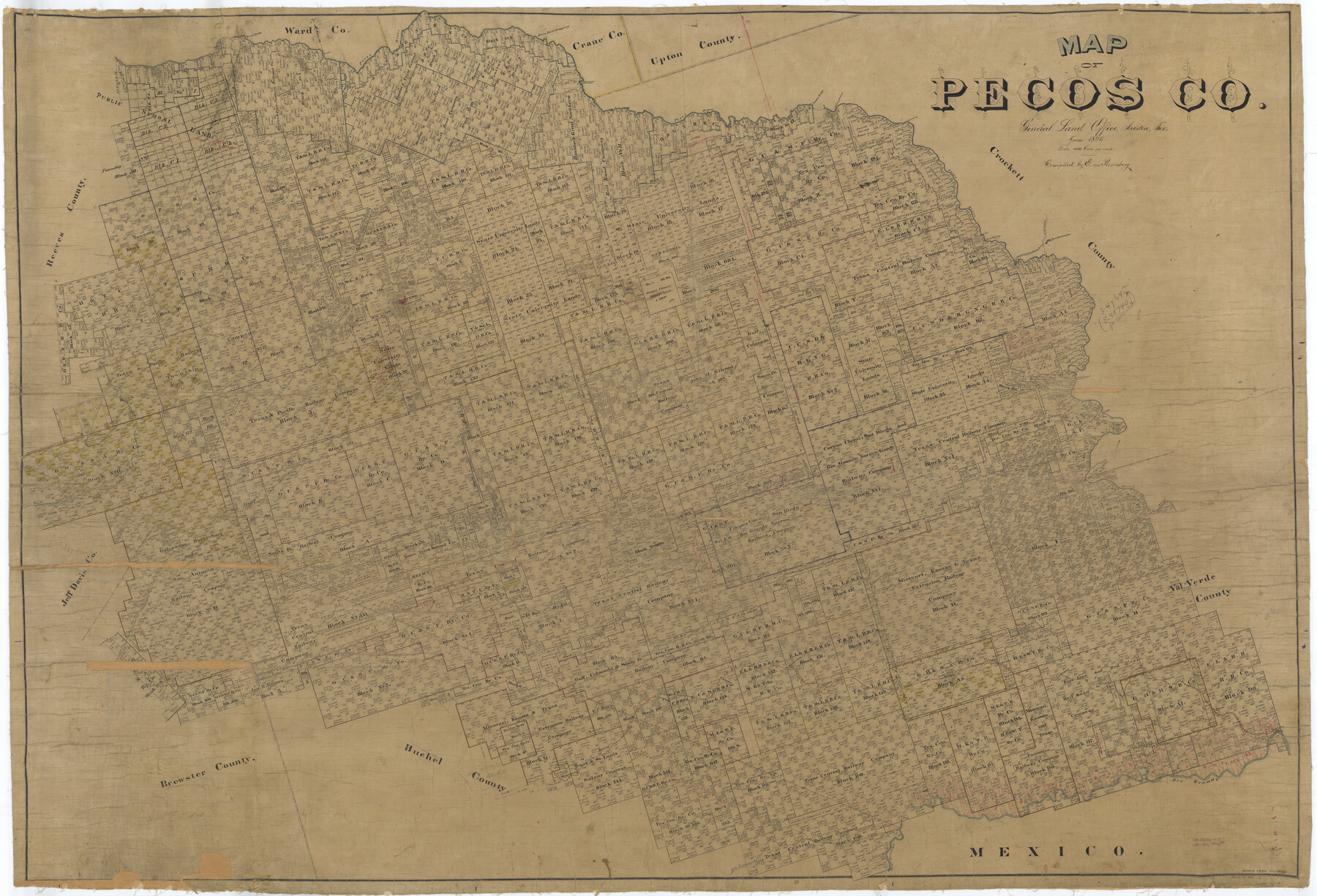
Map of Pecos Co.
-
Map/Doc
76038
-
Collection
General Map Collection
-
Object Dates
1896 (Creation Date)
-
People and Organizations
Texas General Land Office (Publisher)
E. von Rosenberg (Compiler)
-
Counties
Pecos
-
Subjects
County
-
Height x Width
47.7 x 70.1 inches
121.2 x 178.1 cm
-
Comments
Copied by F. G. Blau.
Part of: General Map Collection
Brazoria County Sketch File 1

Print $4.00
- Digital $50.00
Brazoria County Sketch File 1
1861
Size 9.7 x 8.3 inches
Map/Doc 14916
Menard County Rolled Sketch 12

Print $20.00
- Digital $50.00
Menard County Rolled Sketch 12
Size 14.4 x 21.7 inches
Map/Doc 6758
Baylor County Rolled Sketch BT

Print $20.00
- Digital $50.00
Baylor County Rolled Sketch BT
1916
Size 21.4 x 24.0 inches
Map/Doc 5131
Howard County Sketch File 5

Print $3.00
- Digital $50.00
Howard County Sketch File 5
Size 20.0 x 12.8 inches
Map/Doc 11794
Mills County Boundary File Index

Print $2.00
- Digital $50.00
Mills County Boundary File Index
Size 8.8 x 8.9 inches
Map/Doc 57258
Hood County Rolled Sketch 4

Print $20.00
- Digital $50.00
Hood County Rolled Sketch 4
Size 33.4 x 43.1 inches
Map/Doc 6220
Brewster County Rolled Sketch 130

Print $20.00
- Digital $50.00
Brewster County Rolled Sketch 130
1978
Size 18.4 x 24.6 inches
Map/Doc 5302
Galveston County NRC Article 33.136 Sketch 8

Print $20.00
- Digital $50.00
Galveston County NRC Article 33.136 Sketch 8
2002
Size 32.3 x 26.0 inches
Map/Doc 61590
Kimble County Rolled Sketch 26

Print $20.00
- Digital $50.00
Kimble County Rolled Sketch 26
1960
Size 26.4 x 21.6 inches
Map/Doc 6516
Gray County Sketch File 5

Print $16.00
- Digital $50.00
Gray County Sketch File 5
1882
Size 12.8 x 8.3 inches
Map/Doc 24418
Presidio County Sketch File P2

Print $6.00
- Digital $50.00
Presidio County Sketch File P2
Size 14.3 x 8.9 inches
Map/Doc 34558
Cass County Sketch File 1

Print $4.00
- Digital $50.00
Cass County Sketch File 1
1857
Size 11.6 x 8.2 inches
Map/Doc 17392
You may also like
Map of the Mexican Central Railway and Connections

Print $20.00
- Digital $50.00
Map of the Mexican Central Railway and Connections
1892
Size 22.0 x 26.0 inches
Map/Doc 95742
Dallam County Sketch File 13

Print $20.00
- Digital $50.00
Dallam County Sketch File 13
Size 22.2 x 20.3 inches
Map/Doc 11280
Flight Mission No. DQN-5K, Frame 57, Calhoun County

Print $20.00
- Digital $50.00
Flight Mission No. DQN-5K, Frame 57, Calhoun County
1953
Size 18.9 x 22.4 inches
Map/Doc 84400
Flight Mission No. CRC-5R, Frame 42, Chambers County

Print $20.00
- Digital $50.00
Flight Mission No. CRC-5R, Frame 42, Chambers County
1956
Size 18.6 x 22.3 inches
Map/Doc 84961
Culberson County Sketch File 20

Print $57.00
- Digital $50.00
Culberson County Sketch File 20
Size 10.2 x 15.6 inches
Map/Doc 20205
Anderson County Working Sketch 4

Print $20.00
- Digital $50.00
Anderson County Working Sketch 4
Size 15.9 x 21.4 inches
Map/Doc 67003
[Map Showing Estivan Martinez "Los Nerios de Tio Ayola" Survey and Surveys North Thereof, Brooks County, Texas]
![10755, [Map Showing Estivan Martinez "Los Nerios de Tio Ayola" Survey and Surveys North Thereof, Brooks County, Texas], Maddox Collection](https://historictexasmaps.com/wmedia_w700/maps/10755.tif.jpg)
Print $20.00
- Digital $50.00
[Map Showing Estivan Martinez "Los Nerios de Tio Ayola" Survey and Surveys North Thereof, Brooks County, Texas]
1906
Size 16.7 x 25.1 inches
Map/Doc 10755
Brewster County Working Sketch 61

Print $20.00
- Digital $50.00
Brewster County Working Sketch 61
1955
Size 32.1 x 43.3 inches
Map/Doc 67662
Van Zandt County Rolled Sketch 10

Print $20.00
- Digital $50.00
Van Zandt County Rolled Sketch 10
1989
Size 33.7 x 40.6 inches
Map/Doc 10092
General Highway Map, Comanche County, Texas

Print $20.00
General Highway Map, Comanche County, Texas
1940
Size 25.3 x 18.4 inches
Map/Doc 79056
Cameron County Rolled Sketch 28C

Print $20.00
- Digital $50.00
Cameron County Rolled Sketch 28C
Size 20.3 x 16.3 inches
Map/Doc 5393
Flight Mission No. CRC-4R, Frame 106, Chambers County

Print $20.00
- Digital $50.00
Flight Mission No. CRC-4R, Frame 106, Chambers County
1956
Size 18.6 x 22.3 inches
Map/Doc 84903