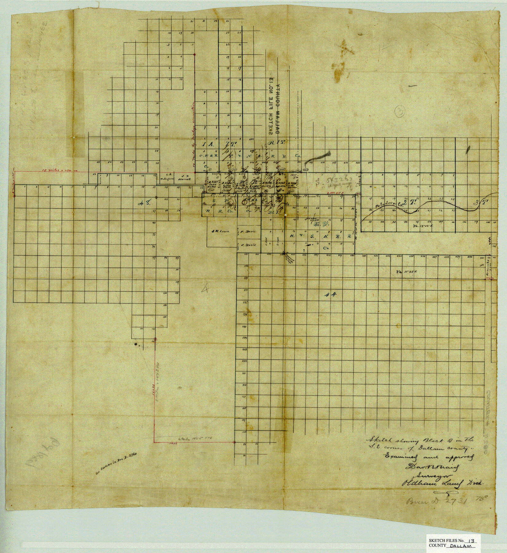
Dallam County Sketch File 13
Sketch showing Block B in the S. E. corner of Dallam County
-
Map/Doc
11280
-
Collection
General Map Collection
-
Object Dates
1891 (File Date)
-
People and Organizations
Dav. B. Braid (Surveyor/Engineer)
-
Counties
Dallam Hartley Moore Sherman
-
Subjects
Surveying Sketch File
-
Height x Width
22.2 x 20.3 inches
56.4 x 51.6 cm
-
Medium
paper, manuscript
-
Features
Paladora Creek
Part of: General Map Collection
Mills County Working Sketch 23

Print $20.00
- Digital $50.00
Mills County Working Sketch 23
1985
Size 22.8 x 36.8 inches
Map/Doc 71053
Wheeler County Rolled Sketch 1

Print $20.00
- Digital $50.00
Wheeler County Rolled Sketch 1
1941
Size 43.9 x 23.7 inches
Map/Doc 10136
Flight Mission No. CRK-3P, Frame 66, Refugio County

Print $20.00
- Digital $50.00
Flight Mission No. CRK-3P, Frame 66, Refugio County
1956
Size 18.6 x 22.4 inches
Map/Doc 86908
Trinity County Sketch File 17

Print $4.00
- Digital $50.00
Trinity County Sketch File 17
Size 8.0 x 7.4 inches
Map/Doc 38546
In the Supreme Court of the United States, The State of Oklahoma, Complainant vs. The State of Texas, Defendant, The United States of America, Intervener, Red River Valley, Texas and Oklahoma Between the 98th and 100th Meridians in Five Sheets, 1921

Print $40.00
- Digital $50.00
In the Supreme Court of the United States, The State of Oklahoma, Complainant vs. The State of Texas, Defendant, The United States of America, Intervener, Red River Valley, Texas and Oklahoma Between the 98th and 100th Meridians in Five Sheets, 1921
Size 38.3 x 60.1 inches
Map/Doc 75279
Aransas County Boundary File 6

Print $156.00
- Digital $50.00
Aransas County Boundary File 6
Size 14.1 x 8.5 inches
Map/Doc 49806
Brazoria County Sketch File 13

Print $40.00
- Digital $50.00
Brazoria County Sketch File 13
Size 23.8 x 23.0 inches
Map/Doc 10950
[Map of Texas and Pacific Blocks from Brazos River westward through Palo Pinto, Stephens, Shackelford, Jones, Callahan, Taylor, Fisher, Nolan and Mitchell Counties]
![93457, [Map of Texas and Pacific Blocks from Brazos River westward through Palo Pinto, Stephens, Shackelford, Jones, Callahan, Taylor, Fisher, Nolan and Mitchell Counties], General Map Collection](https://historictexasmaps.com/wmedia_w700/maps/93457-1.tif.jpg)
Print $20.00
- Digital $50.00
[Map of Texas and Pacific Blocks from Brazos River westward through Palo Pinto, Stephens, Shackelford, Jones, Callahan, Taylor, Fisher, Nolan and Mitchell Counties]
Size 35.0 x 19.3 inches
Map/Doc 93457
Harris County Rolled Sketch 30

Print $20.00
- Digital $50.00
Harris County Rolled Sketch 30
1889
Size 30.4 x 35.1 inches
Map/Doc 6096
[Surveys in the Milam District]
![69729, [Surveys in the Milam District], General Map Collection](https://historictexasmaps.com/wmedia_w700/maps/69729.tif.jpg)
Print $2.00
- Digital $50.00
[Surveys in the Milam District]
1845
Size 9.5 x 6.7 inches
Map/Doc 69729
Karnes County Rolled Sketch 2

Print $20.00
- Digital $50.00
Karnes County Rolled Sketch 2
1957
Size 35.3 x 30.0 inches
Map/Doc 6453
Hutchinson County Working Sketch Graphic Index - sheet 1

Print $20.00
- Digital $50.00
Hutchinson County Working Sketch Graphic Index - sheet 1
1922
Size 44.1 x 36.8 inches
Map/Doc 76586
You may also like
Texas Gulf Coast from Sabine River to Rio Grande As Subdivided for Mineral Development - Obsolete

Print $40.00
- Digital $50.00
Texas Gulf Coast from Sabine River to Rio Grande As Subdivided for Mineral Development - Obsolete
1948
Size 42.0 x 70.8 inches
Map/Doc 2946
Terrell County Rolled Sketch 37

Print $20.00
- Digital $50.00
Terrell County Rolled Sketch 37
1940
Size 23.8 x 33.3 inches
Map/Doc 7941
Map of Texas to Accompany Granger's Southern and Western Texas Guide

Print $20.00
Map of Texas to Accompany Granger's Southern and Western Texas Guide
1878
Size 26.4 x 20.4 inches
Map/Doc 76235
Henderson County Working Sketch 18

Print $20.00
- Digital $50.00
Henderson County Working Sketch 18
1941
Size 23.8 x 23.4 inches
Map/Doc 66151
Gregg County Sketch File 14

Print $6.00
- Digital $50.00
Gregg County Sketch File 14
1946
Size 14.3 x 8.8 inches
Map/Doc 24613
[Surveying Sketch of Martha G. Morrow, Mary Bigger, et al in Travis County]
![522, [Surveying Sketch of Martha G. Morrow, Mary Bigger, et al in Travis County], Maddox Collection](https://historictexasmaps.com/wmedia_w700/maps/522.tif.jpg)
Print $3.00
- Digital $50.00
[Surveying Sketch of Martha G. Morrow, Mary Bigger, et al in Travis County]
Size 12.4 x 9.6 inches
Map/Doc 522
Val Verde County Working Sketch 113

Print $40.00
- Digital $50.00
Val Verde County Working Sketch 113
2003
Size 54.9 x 34.6 inches
Map/Doc 78492
County and Railroad Map of Texas

Print $20.00
- Digital $50.00
County and Railroad Map of Texas
1871
Size 16.7 x 15.5 inches
Map/Doc 95752
Engineer map showing engineer information at 23 O'Clock 23 Oct. 1918 drawn under direction of Col. W.A. Mitchell

Print $20.00
Engineer map showing engineer information at 23 O'Clock 23 Oct. 1918 drawn under direction of Col. W.A. Mitchell
1918
Size 19.6 x 12.5 inches
Map/Doc 94127
Hemphill County Rolled Sketch 13

Print $20.00
- Digital $50.00
Hemphill County Rolled Sketch 13
1905
Size 20.7 x 28.9 inches
Map/Doc 6193
T. C. Ivey Ranch, Block D, Yoakum Co., Texas

Print $20.00
- Digital $50.00
T. C. Ivey Ranch, Block D, Yoakum Co., Texas
Size 17.1 x 14.6 inches
Map/Doc 91976
Nueces County Sketch File 15

Print $4.00
- Digital $50.00
Nueces County Sketch File 15
1874
Size 7.9 x 9.9 inches
Map/Doc 32545