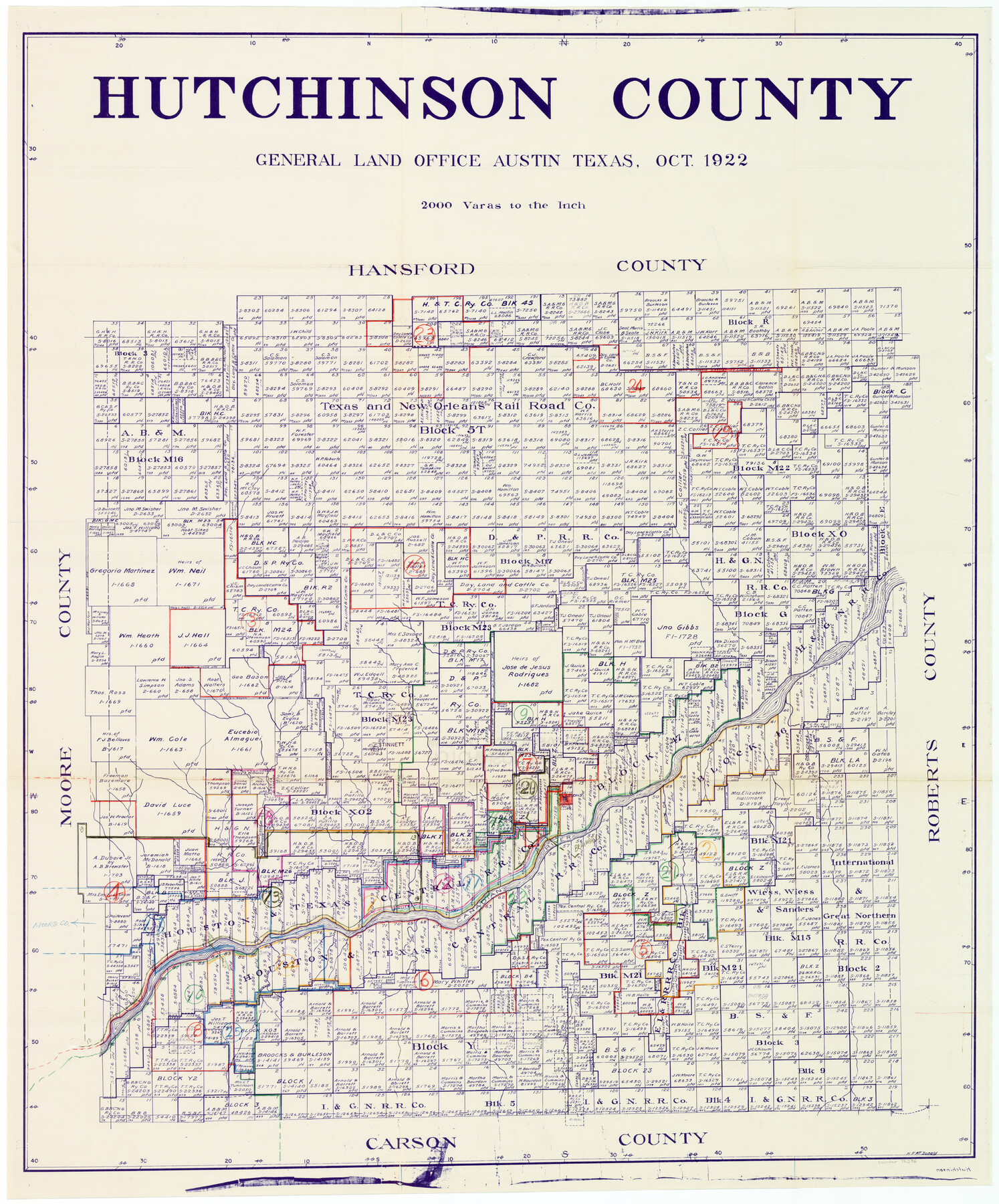
Hutchinson County Working Sketch Graphic Index - sheet 1
-
Map/Doc
76586
-
Collection
General Map Collection
-
Object Dates
10/1922 (Creation Date)
-
People and Organizations
H.F. McDonald (Draftsman)
-
Counties
Hutchinson
-
Subjects
County Surveying Working Sketch
-
Height x Width
44.1 x 36.8 inches
112.0 x 93.5 cm
-
Scale
1" = 2000 varas
Related maps
Hutchinson County Working Sketch Graphic Index - sheet 2

Print $20.00
- Digital $50.00
Hutchinson County Working Sketch Graphic Index - sheet 2
1922
Size 43.8 x 36.7 inches
Map/Doc 76587
Part of: General Map Collection
Right of Way and Track Map, International & Gt. Northern Ry. Operated by the International & Gt. Northern Ry. Co., Gulf Division

Print $40.00
- Digital $50.00
Right of Way and Track Map, International & Gt. Northern Ry. Operated by the International & Gt. Northern Ry. Co., Gulf Division
1917
Size 24.9 x 56.6 inches
Map/Doc 64250
Concho, San Saba & Llano Valley Railway, Sterling City Branch, Texas. Right of Way and Track Map

Print $40.00
- Digital $50.00
Concho, San Saba & Llano Valley Railway, Sterling City Branch, Texas. Right of Way and Track Map
1910
Size 17.7 x 57.8 inches
Map/Doc 64437
Harris County Historic Topographic 18

Print $20.00
- Digital $50.00
Harris County Historic Topographic 18
1916
Size 29.4 x 23.0 inches
Map/Doc 65828
Val Verde County Rolled Sketch 54

Print $40.00
- Digital $50.00
Val Verde County Rolled Sketch 54
1938
Size 63.5 x 44.0 inches
Map/Doc 8123
Brazoria County Working Sketch 16

Print $20.00
- Digital $50.00
Brazoria County Working Sketch 16
1943
Size 35.3 x 32.3 inches
Map/Doc 67501
Railroad Track Map, H&TCRRCo., Falls County, Texas

Print $4.00
- Digital $50.00
Railroad Track Map, H&TCRRCo., Falls County, Texas
1918
Size 11.8 x 18.5 inches
Map/Doc 62837
Colorado County Sketch File 5

Print $4.00
- Digital $50.00
Colorado County Sketch File 5
Size 12.5 x 8.3 inches
Map/Doc 18919
San Jacinto County Working Sketch 13

Print $20.00
- Digital $50.00
San Jacinto County Working Sketch 13
1935
Size 25.0 x 18.8 inches
Map/Doc 63726
Hutchinson County Sketch File 32

Print $20.00
- Digital $50.00
Hutchinson County Sketch File 32
1924
Size 16.7 x 18.0 inches
Map/Doc 11820
Galveston County NRC Article 33.136 Sketch 60

Print $88.00
- Digital $50.00
Galveston County NRC Article 33.136 Sketch 60
2009
Size 24.0 x 36.0 inches
Map/Doc 89263
Calhoun County Boundary File 5

Print $10.00
- Digital $50.00
Calhoun County Boundary File 5
Size 14.2 x 8.8 inches
Map/Doc 51009
Flight Mission No. BRA-6M, Frame 148, Jefferson County

Print $20.00
- Digital $50.00
Flight Mission No. BRA-6M, Frame 148, Jefferson County
1953
Size 18.5 x 22.4 inches
Map/Doc 85449
You may also like
Red River County Sketch File 17a

Print $4.00
- Digital $50.00
Red River County Sketch File 17a
1853
Size 12.6 x 8.1 inches
Map/Doc 35145
Sketch of coast of Texas, Laguna Madre from Pt. of Rocks to Corpus Christi [and accompanying letter]
![72964, Sketch of coast of Texas, Laguna Madre from Pt. of Rocks to Corpus Christi [and accompanying letter], General Map Collection](https://historictexasmaps.com/wmedia_w700/maps/72964.tif.jpg)
Print $2.00
- Digital $50.00
Sketch of coast of Texas, Laguna Madre from Pt. of Rocks to Corpus Christi [and accompanying letter]
Size 11.2 x 8.8 inches
Map/Doc 72964
Lipscomb County Sketch File 3

Print $20.00
- Digital $50.00
Lipscomb County Sketch File 3
Size 36.5 x 8.4 inches
Map/Doc 10526
Surveyors report on resurvey of Capitol Leagues in three parts, also copy of judgement of the District Court, Travis County

Print $20.00
- Digital $50.00
Surveyors report on resurvey of Capitol Leagues in three parts, also copy of judgement of the District Court, Travis County
Size 12.3 x 15.8 inches
Map/Doc 62579
Motley County Boundary File 2b

Print $60.00
- Digital $50.00
Motley County Boundary File 2b
Size 14.3 x 8.8 inches
Map/Doc 57521
Real County Working Sketch 70

Print $20.00
- Digital $50.00
Real County Working Sketch 70
1976
Size 32.3 x 31.8 inches
Map/Doc 71962
Kerr County Working Sketch 18

Print $20.00
- Digital $50.00
Kerr County Working Sketch 18
1956
Size 25.4 x 29.3 inches
Map/Doc 70049
Flight Mission No. DQN-5K, Frame 55, Calhoun County

Print $20.00
- Digital $50.00
Flight Mission No. DQN-5K, Frame 55, Calhoun County
1953
Size 18.7 x 22.3 inches
Map/Doc 84398
Presidio County Working Sketch 44

Print $20.00
- Digital $50.00
Presidio County Working Sketch 44
1949
Size 29.8 x 20.6 inches
Map/Doc 71721
Current Miscellaneous File 114

Print $16.00
- Digital $50.00
Current Miscellaneous File 114
1985
Size 8.9 x 11.3 inches
Map/Doc 74803
Lampasas County Boundary File 10

Print $11.00
- Digital $50.00
Lampasas County Boundary File 10
Size 12.8 x 7.9 inches
Map/Doc 56184
Terlingua Special Map, The University of Texas Mineral Survey, Brewster County, Texas

Print $20.00
- Digital $50.00
Terlingua Special Map, The University of Texas Mineral Survey, Brewster County, Texas
1902
Size 20.4 x 22.6 inches
Map/Doc 482