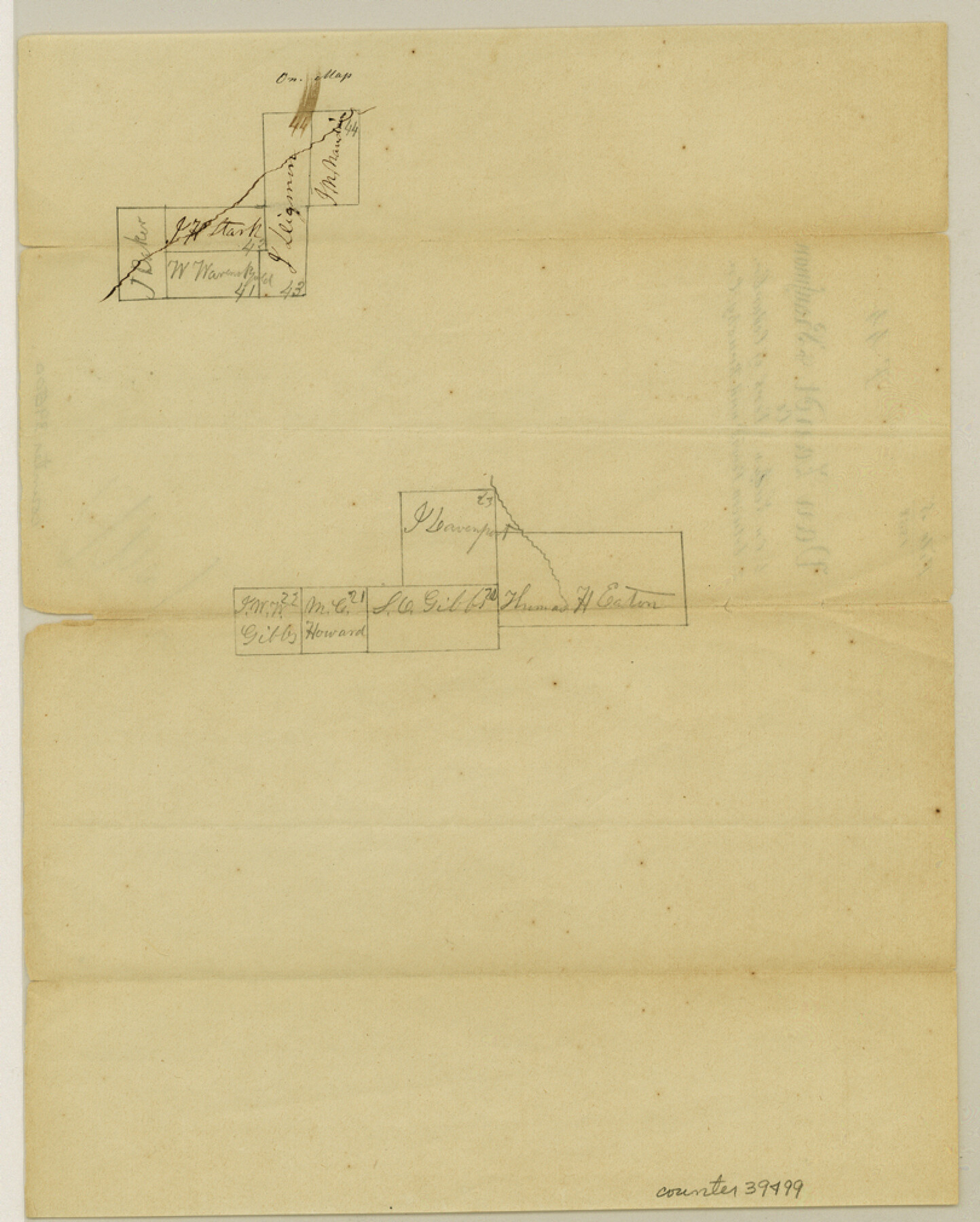
Van Zandt County Sketch File 44
[Sketch of surveys on Lacy Fork southwest from Canton]
-
Map/Doc
39499
-
Collection
General Map Collection
-
Object Dates
1858 (Creation Date)
-
Counties
Van Zandt Kaufman
-
Subjects
Surveying Sketch File
-
Height x Width
10.1 x 8.1 inches
25.7 x 20.6 cm
-
Medium
paper, manuscript
-
Comments
Also contains a sketch of surveys in Kaufman County in the southeast part of that county.
-
Features
Lucy's Fork of Cedar Creek
Ferris Creek
Brushy Creek
Part of: General Map Collection
Red River Co.

Print $40.00
- Digital $50.00
Red River Co.
1897
Size 48.0 x 39.4 inches
Map/Doc 66993
Crockett County Rolled Sketch 88B

Print $20.00
- Digital $50.00
Crockett County Rolled Sketch 88B
1973
Size 35.1 x 38.9 inches
Map/Doc 8727

Travis Station Map - Tracks and Structures - Lands San Antonio and Aransas Pass Railway Co.

Print $4.00
- Digital $50.00
Travis Station Map - Tracks and Structures - Lands San Antonio and Aransas Pass Railway Co.
1919
Size 11.7 x 18.5 inches
Map/Doc 62563
Flight Mission No. DCL-6C, Frame 180, Kenedy County

Print $20.00
- Digital $50.00
Flight Mission No. DCL-6C, Frame 180, Kenedy County
1943
Size 18.5 x 22.4 inches
Map/Doc 85992
A Traveler's Map of Spain and Portugal

A Traveler's Map of Spain and Portugal
Size 20.4 x 31.2 inches
Map/Doc 95929
Real County Working Sketch 31

Print $20.00
- Digital $50.00
Real County Working Sketch 31
1948
Size 20.2 x 25.2 inches
Map/Doc 71923
Gregg County Sketch File 1E

Print $4.00
- Digital $50.00
Gregg County Sketch File 1E
1849
Size 12.6 x 8.2 inches
Map/Doc 24545
Limestone County Sketch File 22

Print $4.00
- Digital $50.00
Limestone County Sketch File 22
Size 11.4 x 7.3 inches
Map/Doc 30201
Brewster County Rolled Sketch 42

Print $20.00
- Digital $50.00
Brewster County Rolled Sketch 42
1912
Size 18.5 x 43.3 inches
Map/Doc 5220
Montague County Working Sketch 16

Print $20.00
- Digital $50.00
Montague County Working Sketch 16
1946
Size 44.1 x 40.8 inches
Map/Doc 71082
Coast Chart No. 211 - Padre I. and Laguna Madre, Lat. 27° 12' to Lat. 26° 33', Texas

Print $20.00
- Digital $50.00
Coast Chart No. 211 - Padre I. and Laguna Madre, Lat. 27° 12' to Lat. 26° 33', Texas
1890
Size 41.0 x 33.4 inches
Map/Doc 73501
You may also like
Portion of Lynn and Terry Counties

Print $20.00
- Digital $50.00
Portion of Lynn and Terry Counties
Size 34.2 x 35.5 inches
Map/Doc 92934

West Part of Liberty Co.

Print $40.00
- Digital $50.00
West Part of Liberty Co.
1977
Size 48.0 x 36.9 inches
Map/Doc 95570
Cass County Rolled Sketch 2

Print $20.00
- Digital $50.00
Cass County Rolled Sketch 2
1936
Size 35.2 x 18.0 inches
Map/Doc 5409
Val Verde County Rolled Sketch JR

Print $20.00
- Digital $50.00
Val Verde County Rolled Sketch JR
1938
Size 35.9 x 31.1 inches
Map/Doc 10080
Pecos County Sketch File 83

Print $6.00
- Digital $50.00
Pecos County Sketch File 83
1884
Size 11.3 x 8.7 inches
Map/Doc 33950
Bastrop County Sketch File 5

Print $4.00
- Digital $50.00
Bastrop County Sketch File 5
Size 8.1 x 10.2 inches
Map/Doc 14048
Brewster County Sketch File N-17

Print $80.00
- Digital $50.00
Brewster County Sketch File N-17
1939
Size 8.9 x 14.4 inches
Map/Doc 15651
Hill County Sketch File 18

Print $26.00
- Digital $50.00
Hill County Sketch File 18
1852
Size 8.6 x 4.9 inches
Map/Doc 26486
Smith County Rolled Sketch 6C

Print $20.00
- Digital $50.00
Smith County Rolled Sketch 6C
1943
Size 25.7 x 34.4 inches
Map/Doc 10701

McMullen County Sketch File 35

Print $10.00
- Digital $50.00
McMullen County Sketch File 35
Size 9.7 x 8.5 inches
Map/Doc 31402