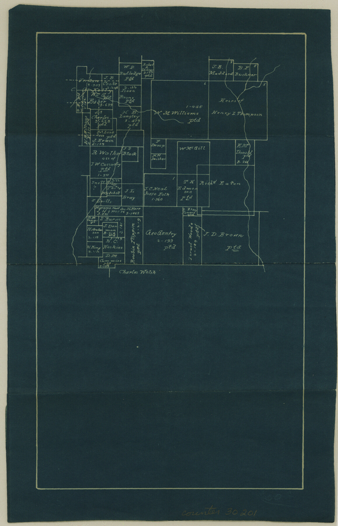
Limestone County Sketch File 22
[Sketch of surveys around the Jessie Folk survey, southwest of Groesbeck]
-
Map/Doc
30201
-
Collection
General Map Collection
-
Counties
Limestone Falls
-
Subjects
Surveying Sketch File
-
Height x Width
11.4 x 7.3 inches
29.0 x 18.5 cm
-
Medium
blueprint/diazo
Part of: General Map Collection
Stonewall County Rolled Sketch 11A

Print $20.00
- Digital $50.00
Stonewall County Rolled Sketch 11A
Size 33.4 x 28.2 inches
Map/Doc 7868
Presidio County Rolled Sketch 131A

Print $20.00
- Digital $50.00
Presidio County Rolled Sketch 131A
1975
Size 30.5 x 24.9 inches
Map/Doc 10706
Floyd County Working Sketch 10

Print $20.00
- Digital $50.00
Floyd County Working Sketch 10
1916
Size 15.4 x 27.3 inches
Map/Doc 69189
Dimmit County Sketch File 9a

Print $4.00
- Digital $50.00
Dimmit County Sketch File 9a
Size 12.7 x 8.2 inches
Map/Doc 21073
Freestone County Working Sketch 22

Print $20.00
- Digital $50.00
Freestone County Working Sketch 22
1981
Size 35.5 x 32.3 inches
Map/Doc 69264

Polk County Working Sketch 8

Print $20.00
- Digital $50.00
Polk County Working Sketch 8
1934
Size 24.2 x 30.5 inches
Map/Doc 71623
Webb County Sketch File 73

Print $20.00
- Digital $50.00
Webb County Sketch File 73
2020
Size 11.0 x 8.5 inches
Map/Doc 95917
Flight Mission No. BRE-1P, Frame 27, Nueces County

Print $20.00
- Digital $50.00
Flight Mission No. BRE-1P, Frame 27, Nueces County
1956
Size 18.5 x 22.4 inches
Map/Doc 86622
United States - Gulf Coast Texas - Southern part of Laguna Madre

Print $20.00
- Digital $50.00
United States - Gulf Coast Texas - Southern part of Laguna Madre
1933
Size 26.8 x 18.3 inches
Map/Doc 72949
Frio County Sketch File 11

Print $4.00
- Digital $50.00
Frio County Sketch File 11
1912
Size 8.4 x 11.2 inches
Map/Doc 23125
Garza County Sketch File 26

Print $4.00
- Digital $50.00
Garza County Sketch File 26
Size 10.9 x 8.5 inches
Map/Doc 24095
You may also like
Matagorda County Sketch File 8

Print $4.00
- Digital $50.00
Matagorda County Sketch File 8
1877
Size 12.9 x 8.0 inches
Map/Doc 30750
Andrews County Rolled Sketch 40

Print $20.00
- Digital $50.00
Andrews County Rolled Sketch 40
Size 37.2 x 23.0 inches
Map/Doc 77180
Dawson County Sketch File 22

Print $6.00
- Digital $50.00
Dawson County Sketch File 22
1953
Size 11.2 x 8.7 inches
Map/Doc 20572
General Highway Map, Newton County, Texas

Print $20.00
General Highway Map, Newton County, Texas
1961
Size 19.3 x 25.0 inches
Map/Doc 79612
Working Sketch in Eastland, Stephens, and Palo Pinto Co's.

Print $20.00
- Digital $50.00
Working Sketch in Eastland, Stephens, and Palo Pinto Co's.
1919
Size 40.3 x 35.7 inches
Map/Doc 91995
Current Miscellaneous File 68

Print $22.00
- Digital $50.00
Current Miscellaneous File 68
Size 11.2 x 8.8 inches
Map/Doc 74134
Sutton County Sketch File 38

Print $20.00
- Digital $50.00
Sutton County Sketch File 38
1935
Size 18.2 x 28.3 inches
Map/Doc 12388
Harris County Boundary File 40

Print $8.00
- Digital $50.00
Harris County Boundary File 40
Size 14.2 x 8.7 inches
Map/Doc 54370
Baylor County Working Sketch 4

Print $20.00
- Digital $50.00
Baylor County Working Sketch 4
1938
Size 30.4 x 21.0 inches
Map/Doc 67289
Culberson County Working Sketch 68

Print $40.00
- Digital $50.00
Culberson County Working Sketch 68
1975
Size 48.9 x 33.5 inches
Map/Doc 68522
Hamilton County Working Sketch 16

Print $40.00
- Digital $50.00
Hamilton County Working Sketch 16
1950
Size 48.0 x 40.6 inches
Map/Doc 63354
Duval County Rolled Sketch 26
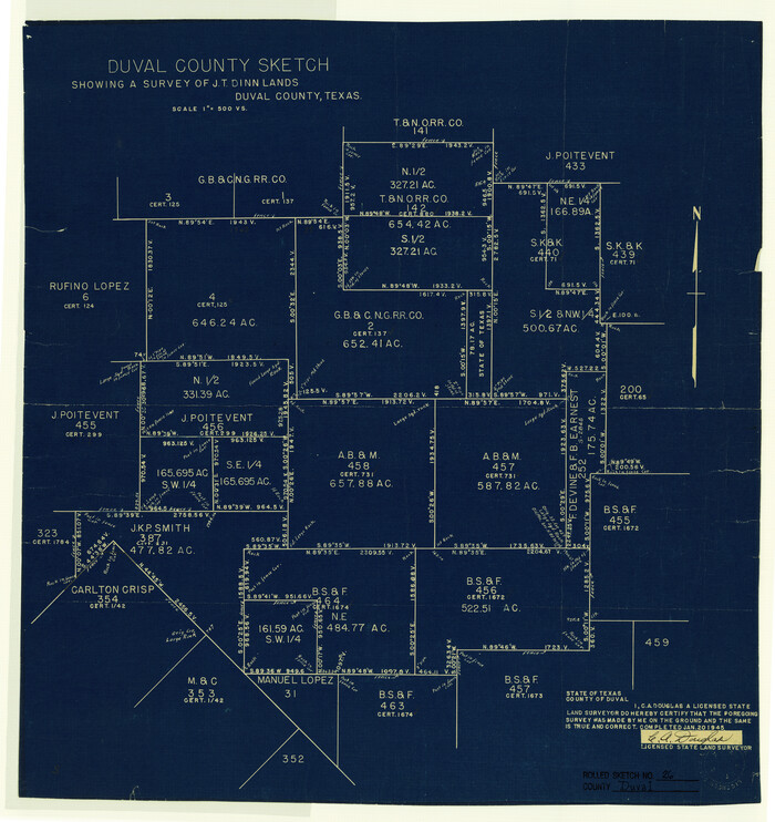
Print $20.00
- Digital $50.00
Duval County Rolled Sketch 26
1945
Size 21.2 x 20.0 inches
Map/Doc 5744