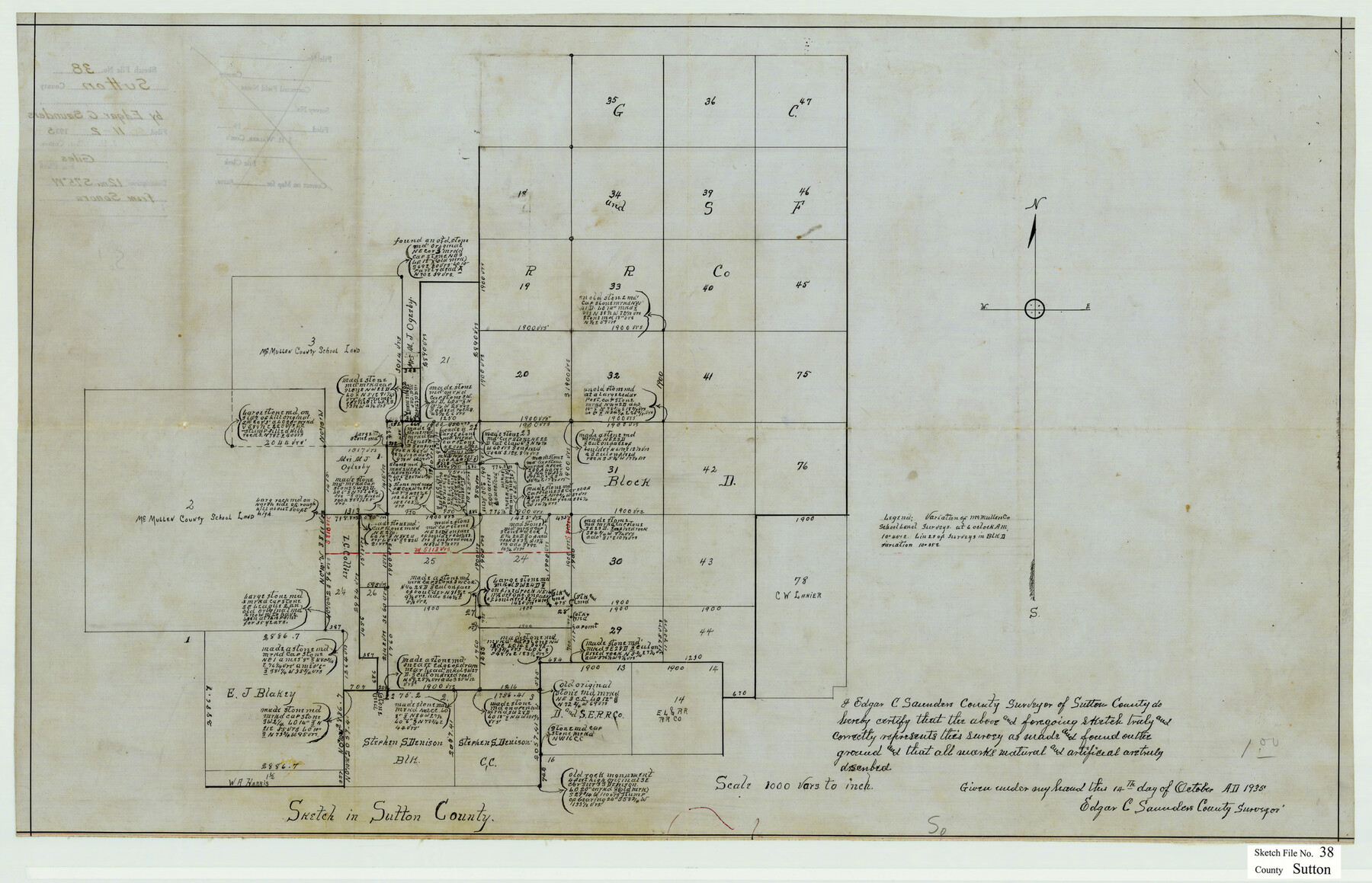
Sutton County Sketch File 38
[Sketch Showing Surveys in Sutton County, Texas]
-
Map/Doc
12388
-
Collection
General Map Collection
-
Object Dates
11/2/1935 (File Date)
10/14/1935 (Creation Date)
-
People and Organizations
Edgar C. Saunders (Surveyor/Engineer)
-
Counties
Sutton
-
Subjects
Surveying Sketch File
-
Height x Width
18.2 x 28.3 inches
46.2 x 71.9 cm
-
Medium
paper, manuscript
-
Scale
1" = 1000 varas
Part of: General Map Collection
Comanche County Sketch File 24 1/2

Print $6.00
- Digital $50.00
Comanche County Sketch File 24 1/2
Size 10.5 x 15.8 inches
Map/Doc 19113

Coryell County Rolled Sketch 2

Print $20.00
- Digital $50.00
Coryell County Rolled Sketch 2
1951
Size 15.7 x 19.1 inches
Map/Doc 5566
Map of Dallas & Wichita Railroad Survey

Print $40.00
- Digital $50.00
Map of Dallas & Wichita Railroad Survey
1874
Size 37.3 x 82.7 inches
Map/Doc 64417
Rains County Sketch File 4

Print $4.00
- Digital $50.00
Rains County Sketch File 4
1853
Size 11.2 x 8.7 inches
Map/Doc 34951
McLennan County Sketch File 12

Print $4.00
- Digital $50.00
McLennan County Sketch File 12
Size 8.3 x 9.3 inches
Map/Doc 31265
Texas-Oklahoma Clara Quadrangle

Print $20.00
- Digital $50.00
Texas-Oklahoma Clara Quadrangle
1937
Size 20.3 x 16.9 inches
Map/Doc 75105
Flight Mission No. CRC-4R, Frame 111, Chambers County

Print $20.00
- Digital $50.00
Flight Mission No. CRC-4R, Frame 111, Chambers County
1956
Size 18.5 x 22.4 inches
Map/Doc 84908
Gray's Geological Map of the United States

Print $20.00
- Digital $50.00
Gray's Geological Map of the United States
1873
Size 17.6 x 28.8 inches
Map/Doc 95174
Garza County Rolled Sketch 11

Print $20.00
- Digital $50.00
Garza County Rolled Sketch 11
1915
Size 31.6 x 20.8 inches
Map/Doc 6000
Cass County Working Sketch 47b

Print $20.00
- Digital $50.00
Cass County Working Sketch 47b
1992
Size 32.3 x 36.4 inches
Map/Doc 76063
Jackson County Sketch File 10

Print $26.00
- Digital $50.00
Jackson County Sketch File 10
1898
Size 11.4 x 8.6 inches
Map/Doc 27653
You may also like
Coleman County

Print $40.00
- Digital $50.00
Coleman County
1945
Size 55.7 x 37.1 inches
Map/Doc 95458
Duval County Sketch File 77

Print $20.00
- Digital $50.00
Duval County Sketch File 77
1967
Size 20.4 x 15.5 inches
Map/Doc 11411
Schleicher County Sketch File 24

Print $35.00
- Digital $50.00
Schleicher County Sketch File 24
1937
Size 10.1 x 14.8 inches
Map/Doc 36516
Dickens County Sketch File 1a

Print $40.00
- Digital $50.00
Dickens County Sketch File 1a
1879
Size 16.8 x 13.8 inches
Map/Doc 20948
General Highway Map. Detail of Cities and Towns in Hale County, Texas [Plainview and vicinity]
![79494, General Highway Map. Detail of Cities and Towns in Hale County, Texas [Plainview and vicinity], Texas State Library and Archives](https://historictexasmaps.com/wmedia_w700/maps/79494.tif.jpg)
Print $20.00
General Highway Map. Detail of Cities and Towns in Hale County, Texas [Plainview and vicinity]
1961
Size 24.6 x 18.2 inches
Map/Doc 79494
Mason County Sketch File 21

Print $6.00
- Digital $50.00
Mason County Sketch File 21
Size 15.7 x 10.9 inches
Map/Doc 30717
Polk County Working Sketch 38

Print $20.00
- Digital $50.00
Polk County Working Sketch 38
1975
Size 25.4 x 23.5 inches
Map/Doc 71655
Gregg County Boundary File 2

Print $8.00
- Digital $50.00
Gregg County Boundary File 2
Size 8.8 x 3.7 inches
Map/Doc 53984
Coryell County Sketch File 24

Print $24.00
- Digital $50.00
Coryell County Sketch File 24
1965
Size 11.2 x 8.8 inches
Map/Doc 19389
General Highway Map, Karnes County, Texas

Print $20.00
General Highway Map, Karnes County, Texas
1940
Size 18.3 x 24.7 inches
Map/Doc 79151
Andrews County Working Sketch 1

Print $20.00
- Digital $50.00
Andrews County Working Sketch 1
1946
Size 40.4 x 37.3 inches
Map/Doc 67047
Victoria County Working Sketch 3

Print $20.00
- Digital $50.00
Victoria County Working Sketch 3
1939
Size 14.0 x 18.3 inches
Map/Doc 72273