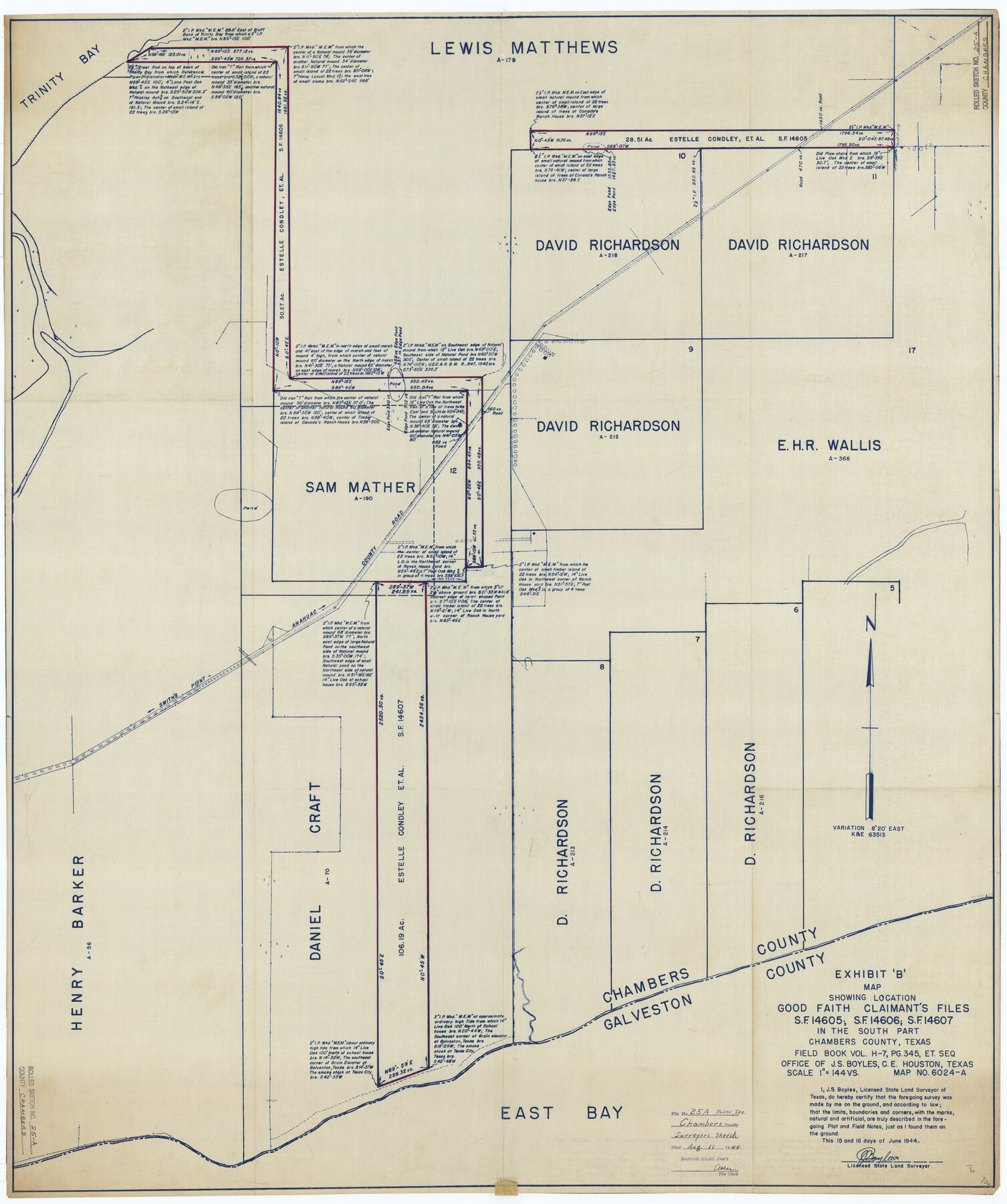
Chambers County Rolled Sketch 25A
Exhibit 'B' - Map showing location Good Faith Claimant's files SF-14605, SF-14606, SF-14607 in the south part Chambers County, Texas
-
Map/Doc
8617
-
Collection
General Map Collection
-
Object Dates
1944/6/16 (Creation Date)
1944/8/11 (File Date)
-
People and Organizations
J.S. Boyles (Surveyor/Engineer)
-
Counties
Chambers
-
Subjects
Surveying Rolled Sketch
-
Height x Width
41.2 x 34.5 inches
104.6 x 87.6 cm
-
Medium
blueprint/diazo
-
Scale
1" = 144 varas
-
Comments
See Chambers County Rolled Sketch 25 (8618) for Exhibit 'A'.
Related maps
Chambers County Rolled Sketch 25

Print $20.00
- Digital $50.00
Chambers County Rolled Sketch 25
1944
Size 33.9 x 31.5 inches
Map/Doc 8618
Part of: General Map Collection
Louisiana and Texas Intracoastal Waterway, Section 7, Galveston Bay to Brazos River and Section 8, Brazos River to Matagorda Bay

Print $20.00
- Digital $50.00
Louisiana and Texas Intracoastal Waterway, Section 7, Galveston Bay to Brazos River and Section 8, Brazos River to Matagorda Bay
1929
Size 30.8 x 43.0 inches
Map/Doc 61841
Dimmit County Rolled Sketch 20

Print $20.00
- Digital $50.00
Dimmit County Rolled Sketch 20
1999
Size 24.6 x 36.6 inches
Map/Doc 5726
[Surveys in the Milam District along the Brazos River, North Bosque River, West Bosque River and Cow Bayou]
![231, [Surveys in the Milam District along the Brazos River, North Bosque River, West Bosque River and Cow Bayou], General Map Collection](https://historictexasmaps.com/wmedia_w700/maps/231.tif.jpg)
Print $2.00
- Digital $50.00
[Surveys in the Milam District along the Brazos River, North Bosque River, West Bosque River and Cow Bayou]
1846
Size 11.7 x 8.9 inches
Map/Doc 231
Map of Texas in 1830 Showing Spanish Colonies

Print $20.00
- Digital $50.00
Map of Texas in 1830 Showing Spanish Colonies
Size 41.1 x 42.0 inches
Map/Doc 73588
Flight Mission No. DAG-17K, Frame 124, Matagorda County

Print $20.00
- Digital $50.00
Flight Mission No. DAG-17K, Frame 124, Matagorda County
1952
Size 18.6 x 22.3 inches
Map/Doc 86344
Mills County Boundary File 11

Print $20.00
- Digital $50.00
Mills County Boundary File 11
Size 17.2 x 22.1 inches
Map/Doc 57333
Flight Mission No. DCL-6C, Frame 124, Kenedy County

Print $20.00
- Digital $50.00
Flight Mission No. DCL-6C, Frame 124, Kenedy County
1943
Size 18.6 x 22.4 inches
Map/Doc 85954
Current Miscellaneous File 90

Print $18.00
- Digital $50.00
Current Miscellaneous File 90
1956
Size 11.2 x 8.8 inches
Map/Doc 74255
Dimmit County Working Sketch 42

Print $20.00
- Digital $50.00
Dimmit County Working Sketch 42
1977
Size 33.5 x 39.6 inches
Map/Doc 68703
Presidio County Working Sketch 93

Print $20.00
- Digital $50.00
Presidio County Working Sketch 93
1976
Size 27.7 x 27.3 inches
Map/Doc 71770
Guadalupe County Sketch File 9

Print $4.00
- Digital $50.00
Guadalupe County Sketch File 9
1862
Size 9.9 x 8.1 inches
Map/Doc 24677
Erath County Sketch File 15

Print $4.00
- Digital $50.00
Erath County Sketch File 15
1872
Size 6.2 x 7.6 inches
Map/Doc 22292
You may also like
[Location Survey of the Southern Kansas Railway, Kiowa Extension from a point in Drake's Location, in Indian Territory 100 miles from south line of Kansas, continuing up Wolf Creek and South Canadian River to Cottonwood Creek in Hutchinson County]
![88845, [Location Survey of the Southern Kansas Railway, Kiowa Extension from a point in Drake's Location, in Indian Territory 100 miles from south line of Kansas, continuing up Wolf Creek and South Canadian River to Cottonwood Creek in Hutchinson County], General Map Collection](https://historictexasmaps.com/wmedia_w700/maps/88845.tif.jpg)
Print $20.00
- Digital $50.00
[Location Survey of the Southern Kansas Railway, Kiowa Extension from a point in Drake's Location, in Indian Territory 100 miles from south line of Kansas, continuing up Wolf Creek and South Canadian River to Cottonwood Creek in Hutchinson County]
1886
Size 37.5 x 36.0 inches
Map/Doc 88845

Edwards County Working Sketch 56

Print $20.00
- Digital $50.00
Edwards County Working Sketch 56
1952
Size 23.6 x 35.7 inches
Map/Doc 68932
Galveston, Harrisburg & San Antonio Railway, Map of Eagle Pass Branch

Print $20.00
- Digital $50.00
Galveston, Harrisburg & San Antonio Railway, Map of Eagle Pass Branch
1888
Size 42.7 x 25.8 inches
Map/Doc 64462
Waller County

Print $20.00
- Digital $50.00
Waller County
1897
Size 46.0 x 30.2 inches
Map/Doc 63107
Gulf Intracoastal Waterway - Tributary Channel to Aransas Pass, Location of Spoil Disposal Areas

Print $20.00
- Digital $50.00
Gulf Intracoastal Waterway - Tributary Channel to Aransas Pass, Location of Spoil Disposal Areas
1961
Size 31.5 x 41.9 inches
Map/Doc 61828
La Salle County Sketch File 28

Print $6.00
- Digital $50.00
La Salle County Sketch File 28
1882
Size 8.7 x 3.6 inches
Map/Doc 29555
San Jacinto County Rolled Sketch 15

Print $20.00
- Digital $50.00
San Jacinto County Rolled Sketch 15
2001
Size 19.2 x 25.2 inches
Map/Doc 7571
Hardeman County Working Sketch 11

Print $40.00
- Digital $50.00
Hardeman County Working Sketch 11
1960
Size 40.0 x 58.1 inches
Map/Doc 63392
Rusk County Working Sketch 35

Print $20.00
- Digital $50.00
Rusk County Working Sketch 35
2005
Size 28.7 x 42.0 inches
Map/Doc 83584
Reagan County

Print $40.00
- Digital $50.00
Reagan County
1940
Size 48.4 x 37.5 inches
Map/Doc 73270
[Part of Block M6]
![91933, [Part of Block M6], Twichell Survey Records](https://historictexasmaps.com/wmedia_w700/maps/91933-1.tif.jpg)
Print $20.00
- Digital $50.00
[Part of Block M6]
Size 31.5 x 6.7 inches
Map/Doc 91933