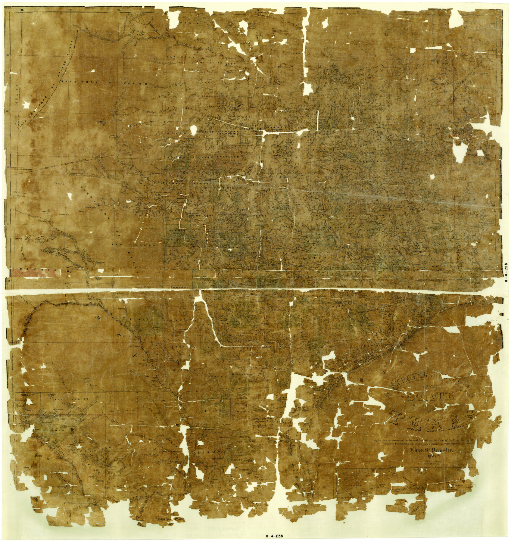
Traveller's Map of the State of Texas
K-4-25b
-
Map/Doc
4327
-
Collection
General Map Collection
-
Object Dates
1867 (Creation Date)
-
People and Organizations
American Photo-Lithographic Company (Printer)
Chas. W. Pressler (Draftsman)
Chas. W. Pressler (Compiler)
-
Subjects
State of Texas
-
Height x Width
40.6 x 38.2 inches
103.1 x 97.0 cm
-
Comments
Map is in poor condition. See map 76226 for a better conditioned copy.
Part of: General Map Collection
Galveston County Rolled Sketch 21

Print $41.00
- Digital $50.00
Galveston County Rolled Sketch 21
Size 10.5 x 15.1 inches
Map/Doc 45061
Calhoun County NRC Article 33.136 Sketch 8

Print $28.00
- Digital $50.00
Calhoun County NRC Article 33.136 Sketch 8
2019
Size 17.9 x 23.8 inches
Map/Doc 95371
Jackson County Working Sketch 8

Print $20.00
- Digital $50.00
Jackson County Working Sketch 8
1980
Size 30.4 x 29.0 inches
Map/Doc 66456
Reeves County Rolled Sketch 14

Print $20.00
- Digital $50.00
Reeves County Rolled Sketch 14
Size 17.7 x 21.8 inches
Map/Doc 7482
Terrell County Rolled Sketch 19

Print $20.00
- Digital $50.00
Terrell County Rolled Sketch 19
1884
Size 22.4 x 26.9 inches
Map/Doc 7927
Tyler County Sketch File 20

Print $6.00
- Digital $50.00
Tyler County Sketch File 20
1851
Size 6.9 x 5.8 inches
Map/Doc 38674
[Sketch of Col. Cooke's Military Road expedition from Red River to Austin]
![166, [Sketch of Col. Cooke's Military Road expedition from Red River to Austin], General Map Collection](https://historictexasmaps.com/wmedia_w700/maps/166.tif.jpg)
Print $20.00
- Digital $50.00
[Sketch of Col. Cooke's Military Road expedition from Red River to Austin]
Size 29.4 x 22.9 inches
Map/Doc 166
Potter County Boundary File 1

Print $12.00
- Digital $50.00
Potter County Boundary File 1
Size 14.1 x 8.7 inches
Map/Doc 57937
Montgomery County Sketch File 39

Print $4.00
- Digital $50.00
Montgomery County Sketch File 39
1941
Size 14.6 x 8.6 inches
Map/Doc 31923
Flight Mission No. BRE-2P, Frame 34, Nueces County

Print $20.00
- Digital $50.00
Flight Mission No. BRE-2P, Frame 34, Nueces County
1956
Size 18.7 x 22.6 inches
Map/Doc 86736
Hoffman & Walker's Pictorial, Historical Map of Texas

Hoffman & Walker's Pictorial, Historical Map of Texas
1960
Size 43.4 x 45.3 inches
Map/Doc 93275
Culberson County Sketch File 11a

Print $4.00
- Digital $50.00
Culberson County Sketch File 11a
1926
Size 14.3 x 8.7 inches
Map/Doc 20172
You may also like
The Republic County of Nacogdoches. January 1, 1838

Print $20.00
The Republic County of Nacogdoches. January 1, 1838
2020
Size 17.5 x 21.7 inches
Map/Doc 96244
La Salle County Sketch File 35

Print $40.00
- Digital $50.00
La Salle County Sketch File 35
Size 12.1 x 19.7 inches
Map/Doc 29587
Martin County Working Sketch 17

Print $20.00
- Digital $50.00
Martin County Working Sketch 17
1981
Size 32.4 x 41.4 inches
Map/Doc 70835
Flight Mission No. BQR-14K, Frame 38, Brazoria County

Print $20.00
- Digital $50.00
Flight Mission No. BQR-14K, Frame 38, Brazoria County
1952
Size 18.8 x 22.3 inches
Map/Doc 84095
Map of Polk County

Print $20.00
- Digital $50.00
Map of Polk County
1881
Size 25.7 x 21.1 inches
Map/Doc 3962
San Patricio County Rolled Sketch BB

Print $40.00
- Digital $50.00
San Patricio County Rolled Sketch BB
1936
Size 25.0 x 49.0 inches
Map/Doc 9889
Schleicher County Sketch File 16

Print $6.00
- Digital $50.00
Schleicher County Sketch File 16
Size 11.6 x 15.4 inches
Map/Doc 36506
Brazos Island Harbor, Texas - Dredging Entrance Channel Plan

Print $20.00
- Digital $50.00
Brazos Island Harbor, Texas - Dredging Entrance Channel Plan
1990
Size 14.6 x 20.0 inches
Map/Doc 83337
Wortham & Williams' Subdivisions of the San Augustine County School Leagues situated in Lubbock Co., Texas

Print $40.00
- Digital $50.00
Wortham & Williams' Subdivisions of the San Augustine County School Leagues situated in Lubbock Co., Texas
1909
Size 38.7 x 52.1 inches
Map/Doc 89935
A map of the Anthracite Coal Fields of Pennsylvania embracing all of Schuylkill County and parts of Carbon, Luzerne, Columbia, Northumberland, Dauphin, and Lebanon Counties

Print $20.00
- Digital $50.00
A map of the Anthracite Coal Fields of Pennsylvania embracing all of Schuylkill County and parts of Carbon, Luzerne, Columbia, Northumberland, Dauphin, and Lebanon Counties
1863
Size 27.1 x 39.3 inches
Map/Doc 94054
Victoria County Working Sketch 2

Print $20.00
- Digital $50.00
Victoria County Working Sketch 2
1939
Size 43.1 x 28.1 inches
Map/Doc 72272
Kimble County

Print $40.00
- Digital $50.00
Kimble County
1930
Size 41.0 x 49.0 inches
Map/Doc 77340