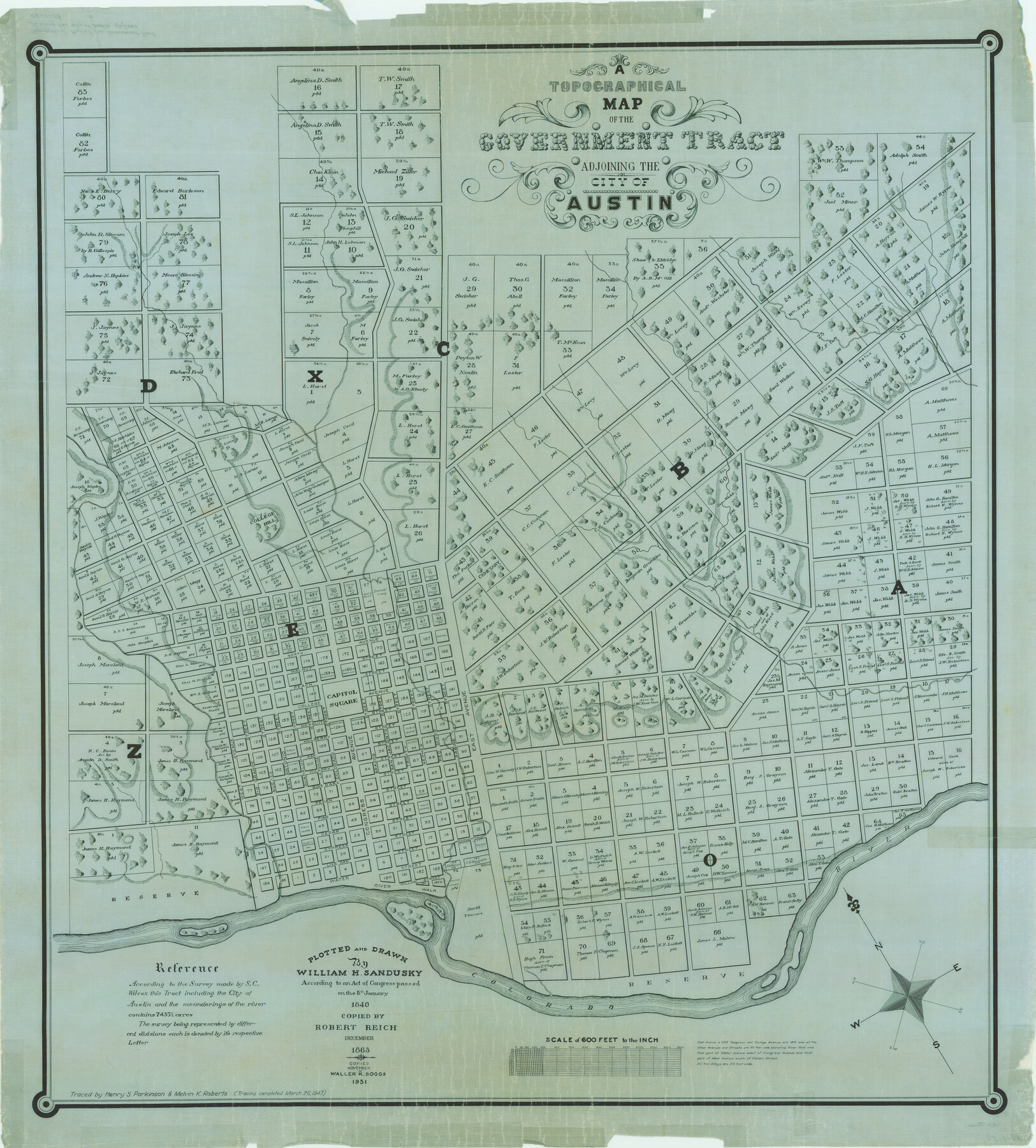
A Topographical Map of the Government Tract adjoining the City of Austin
-
Map/Doc
2180
-
Collection
General Map Collection
-
Object Dates
1840 (Creation Date)
1863 (Copy/Tracing Date)
1931 (Copy/Tracing Date)
1947/3/26 (Copy/Tracing Date)
-
People and Organizations
William H. Sandusky (Draftsman)
Robert Reich (Tracer)
Waller K. Boggs (Tracer)
Henry S. Parkinson (Tracer)
Melvin K. Roberts (Tracer)
-
Counties
Travis
-
Subjects
City
-
Height x Width
41.9 x 37.8 inches
106.4 x 96.0 cm
-
Medium
linen, manuscript
-
Scale
1" = 600 feet
Part of: General Map Collection
La Salle County Sketch File 16

Print $5.00
- Digital $50.00
La Salle County Sketch File 16
1883
Size 9.3 x 9.7 inches
Map/Doc 29487


Van Zandt County Working Sketch 12

Print $20.00
- Digital $50.00
Van Zandt County Working Sketch 12
1982
Size 21.5 x 20.7 inches
Map/Doc 72262
Midland County Working Sketch 3

Print $20.00
- Digital $50.00
Midland County Working Sketch 3
Size 19.5 x 35.2 inches
Map/Doc 70983
Gillespie County Sketch File 7a

Print $4.00
- Digital $50.00
Gillespie County Sketch File 7a
Size 3.5 x 8.1 inches
Map/Doc 24143
Smith County Working Sketch 9

Print $40.00
- Digital $50.00
Smith County Working Sketch 9
1947
Size 48.8 x 44.2 inches
Map/Doc 63894
Bowie County Sketch File 4

Print $4.00
- Digital $50.00
Bowie County Sketch File 4
Size 10.8 x 8.4 inches
Map/Doc 14835
Map of the Surveyed Part of Young District

Print $40.00
- Digital $50.00
Map of the Surveyed Part of Young District
1860
Size 56.3 x 32.6 inches
Map/Doc 87373
La Salle County Rolled Sketch 33

Print $20.00
- Digital $50.00
La Salle County Rolled Sketch 33
2015
Size 17.6 x 27.6 inches
Map/Doc 95306
Current Miscellaneous File 20

Print $22.00
- Digital $50.00
Current Miscellaneous File 20
1952
Size 10.7 x 8.1 inches
Map/Doc 73855
Hudspeth County Working Sketch 21

Print $20.00
- Digital $50.00
Hudspeth County Working Sketch 21
1966
Size 22.8 x 41.6 inches
Map/Doc 66303
You may also like
![4781, Coke Co[unty], General Map Collection](https://historictexasmaps.com/wmedia_w700/maps/4781.tif.jpg)
Childress County Sketch File 18a

Print $4.00
- Digital $50.00
Childress County Sketch File 18a
1935
Size 11.3 x 7.1 inches
Map/Doc 18364
Flight Mission No. CRC-5R, Frame 21, Chambers County

Print $20.00
- Digital $50.00
Flight Mission No. CRC-5R, Frame 21, Chambers County
1956
Size 18.6 x 22.3 inches
Map/Doc 84943

Map of Crockett County

Print $40.00
- Digital $50.00
Map of Crockett County
1878
Size 62.6 x 49.7 inches
Map/Doc 93373
Presidio County Rolled Sketch 102

Print $20.00
- Digital $50.00
Presidio County Rolled Sketch 102
1957
Size 19.3 x 13.8 inches
Map/Doc 7385
Real County Rolled Sketch 18

Print $20.00
- Digital $50.00
Real County Rolled Sketch 18
Size 22.2 x 28.2 inches
Map/Doc 7461
Cass County Working Sketch 47b

Print $20.00
- Digital $50.00
Cass County Working Sketch 47b
1992
Size 32.3 x 36.4 inches
Map/Doc 76063
Maverick County Working Sketch 2

Print $20.00
- Digital $50.00
Maverick County Working Sketch 2
1922
Size 46.2 x 38.5 inches
Map/Doc 70894
Crockett County Sketch File 13

Print $22.00
- Digital $50.00
Crockett County Sketch File 13
Size 8.9 x 3.6 inches
Map/Doc 19665
Schleicher County Sketch File 17

Print $20.00
- Digital $50.00
Schleicher County Sketch File 17
Size 23.4 x 17.8 inches
Map/Doc 12299
United States of North America (Eastern and Central)

Print $20.00
- Digital $50.00
United States of North America (Eastern and Central)
1862
Size 19.3 x 26.2 inches
Map/Doc 93667