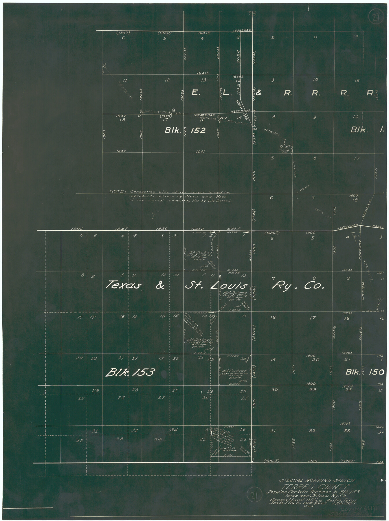
Terrell County Working Sketch 21
-
Map/Doc
62171
-
Collection
General Map Collection
-
Object Dates
1/24/1935 (Creation Date)
-
Counties
Terrell
-
Subjects
Surveying Working Sketch
-
Height x Width
24.0 x 17.9 inches
61.0 x 45.5 cm
-
Scale
1" = 1000 varas
Part of: General Map Collection
Flight Mission No. CRC-4R, Frame 66, Chambers County

Print $20.00
- Digital $50.00
Flight Mission No. CRC-4R, Frame 66, Chambers County
1956
Size 18.6 x 22.5 inches
Map/Doc 84870
Fayette County Boundary File 8

Print $19.00
- Digital $50.00
Fayette County Boundary File 8
Size 14.4 x 9.0 inches
Map/Doc 53402
Duval County Sketch File 45a

Print $9.00
- Digital $50.00
Duval County Sketch File 45a
Size 14.5 x 9.0 inches
Map/Doc 21396
Flight Mission No. CUG-1P, Frame 72, Kleberg County

Print $20.00
- Digital $50.00
Flight Mission No. CUG-1P, Frame 72, Kleberg County
1956
Size 18.6 x 22.1 inches
Map/Doc 86137
Sutton County Working Sketch 32

Print $20.00
- Digital $50.00
Sutton County Working Sketch 32
1933
Size 20.5 x 28.3 inches
Map/Doc 62375
[Surveys along the San Gabriel River]
![78375, [Surveys along the San Gabriel River], General Map Collection](https://historictexasmaps.com/wmedia_w700/maps/78375.tif.jpg)
Print $2.00
- Digital $50.00
[Surveys along the San Gabriel River]
Size 9.0 x 6.3 inches
Map/Doc 78375
Borden County Rolled Sketch 6

Print $20.00
- Digital $50.00
Borden County Rolled Sketch 6
Size 24.6 x 18.6 inches
Map/Doc 5156
Stephens County Sketch File 28

Print $14.00
- Digital $50.00
Stephens County Sketch File 28
1996
Size 14.2 x 8.6 inches
Map/Doc 37104
Brazoria County NRC Article 33.136 Sketch 34

Print $24.00
Brazoria County NRC Article 33.136 Sketch 34
2025
Map/Doc 97478
Van Zandt County Sketch File 19a

Print $4.00
- Digital $50.00
Van Zandt County Sketch File 19a
1858
Size 7.1 x 8.0 inches
Map/Doc 39424
Anderson County Sketch File 9

Print $8.00
- Digital $50.00
Anderson County Sketch File 9
Size 12.5 x 8.2 inches
Map/Doc 12761
Matagorda County Sketch File 27

Print $60.00
- Digital $50.00
Matagorda County Sketch File 27
1908
Size 11.8 x 15.7 inches
Map/Doc 30803
You may also like
Flight Mission No. CLL-3N, Frame 41, Willacy County

Print $20.00
- Digital $50.00
Flight Mission No. CLL-3N, Frame 41, Willacy County
1954
Size 18.4 x 22.1 inches
Map/Doc 87099
Baylor County Boundary File 11

Print $26.00
- Digital $50.00
Baylor County Boundary File 11
Size 11.1 x 8.7 inches
Map/Doc 50419
Maps of Gulf Intracoastal Waterway, Texas - Sabine River to the Rio Grande and connecting waterways including ship channels

Print $20.00
- Digital $50.00
Maps of Gulf Intracoastal Waterway, Texas - Sabine River to the Rio Grande and connecting waterways including ship channels
1966
Size 14.5 x 22.2 inches
Map/Doc 61960
Travis County State Real Property Sketch 18

Print $20.00
Travis County State Real Property Sketch 18
2005
Size 24.4 x 35.2 inches
Map/Doc 96976
San Augustine County Sketch File 22

Print $4.00
San Augustine County Sketch File 22
Size 12.8 x 8.4 inches
Map/Doc 35687
Culberson County Working Sketch 59

Print $20.00
- Digital $50.00
Culberson County Working Sketch 59
1974
Size 46.4 x 37.7 inches
Map/Doc 68513
Travis County Sketch File 73

Print $8.00
- Digital $50.00
Travis County Sketch File 73
1848
Size 12.8 x 8.3 inches
Map/Doc 38464
Flight Mission No. DQN-5K, Frame 30, Calhoun County

Print $20.00
- Digital $50.00
Flight Mission No. DQN-5K, Frame 30, Calhoun County
1953
Size 16.7 x 16.5 inches
Map/Doc 84381
Brewster County Rolled Sketch 43A

Print $40.00
- Digital $50.00
Brewster County Rolled Sketch 43A
Size 39.5 x 65.6 inches
Map/Doc 8477
[Section 34, Block 194 G. C. & S. F.]
![91672, [Section 34, Block 194 G. C. & S. F.], Twichell Survey Records](https://historictexasmaps.com/wmedia_w700/maps/91672-1.tif.jpg)
Print $2.00
- Digital $50.00
[Section 34, Block 194 G. C. & S. F.]
1927
Size 7.5 x 5.9 inches
Map/Doc 91672
Fort Bend County Sketch File 2a

Print $4.00
- Digital $50.00
Fort Bend County Sketch File 2a
Size 12.7 x 8.1 inches
Map/Doc 22878
Crosby County Sketch File 15

Print $20.00
- Digital $50.00
Crosby County Sketch File 15
1903
Size 28.7 x 20.4 inches
Map/Doc 11250