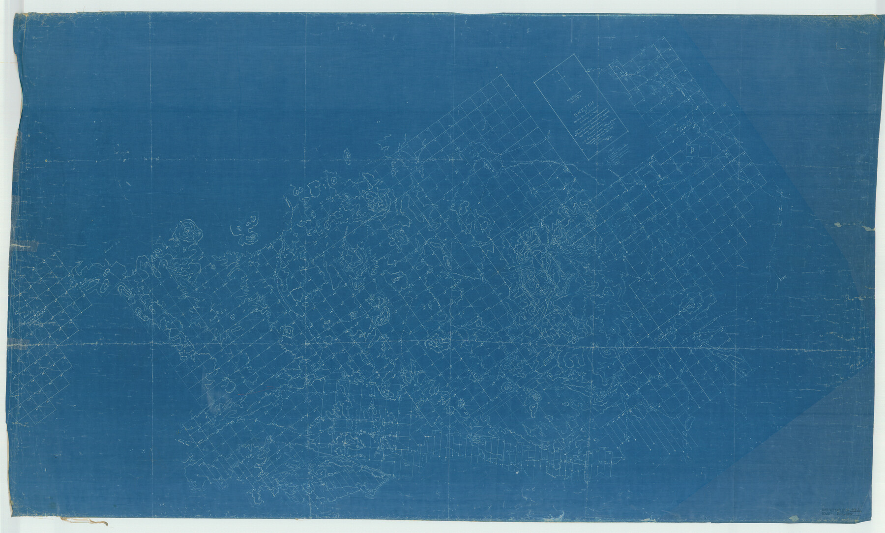
Brewster County Rolled Sketch 43A
Sketch of certain blocks of land in Brewster Co. Texas showing their position & connections as found by actual survey on the ground [with] topography sketched in from the U.S. Topographic Map & from notes made in the field
-
Map/Doc
8477
-
Collection
General Map Collection
-
Object Dates
1913/7/5 (File Date)
-
People and Organizations
R.S. Dod (Surveyor/Engineer)
-
Counties
Brewster
-
Subjects
Surveying Rolled Sketch
-
Height x Width
39.5 x 65.6 inches
100.3 x 166.6 cm
-
Medium
blueprint/diazo
-
Scale
1" = 2000 varas
Part of: General Map Collection
Terrell County Working Sketch 13

Print $20.00
- Digital $50.00
Terrell County Working Sketch 13
1926
Size 30.1 x 22.8 inches
Map/Doc 62162
Flight Mission No. DQO-8K, Frame 49, Galveston County

Print $20.00
- Digital $50.00
Flight Mission No. DQO-8K, Frame 49, Galveston County
1952
Size 18.7 x 22.3 inches
Map/Doc 85156
Orange County Sketch File 12

Print $4.00
- Digital $50.00
Orange County Sketch File 12
1876
Size 12.7 x 7.9 inches
Map/Doc 33324
Uvalde County Rolled Sketch 14

Print $20.00
- Digital $50.00
Uvalde County Rolled Sketch 14
1977
Size 22.0 x 25.9 inches
Map/Doc 8098
Bee County Sketch File 25

Print $4.00
- Digital $50.00
Bee County Sketch File 25
1880
Size 11.0 x 8.2 inches
Map/Doc 14326
Brewster County Rolled Sketch 146A

Print $40.00
- Digital $50.00
Brewster County Rolled Sketch 146A
Size 62.4 x 45.1 inches
Map/Doc 8527
Stephens County Sketch File 9a

Print $4.00
- Digital $50.00
Stephens County Sketch File 9a
1884
Size 8.6 x 8.2 inches
Map/Doc 37040
Galveston County Rolled Sketch 46A

Print $20.00
- Digital $50.00
Galveston County Rolled Sketch 46A
2000
Size 24.9 x 37.6 inches
Map/Doc 5982
Current Miscellaneous File 8

Print $10.00
- Digital $50.00
Current Miscellaneous File 8
Size 14.6 x 9.1 inches
Map/Doc 73736
Kent County Rolled Sketch 5

Print $20.00
- Digital $50.00
Kent County Rolled Sketch 5
1951
Size 43.7 x 36.9 inches
Map/Doc 78522
Upshur County Sketch File 19

Print $40.00
- Digital $50.00
Upshur County Sketch File 19
Size 17.9 x 22.2 inches
Map/Doc 12507
Val Verde County Working Sketch 2

Print $20.00
- Digital $50.00
Val Verde County Working Sketch 2
Size 27.9 x 23.8 inches
Map/Doc 72137
You may also like
[W. E. Halsell's Subdivision of Capitol Leagues, Blocks T1,T2, T3, and S2]
![92164, [W. E. Halsell's Subdivision of Capitol Leagues, Blocks T1,T2, T3, and S2], Twichell Survey Records](https://historictexasmaps.com/wmedia_w700/maps/92164-1.tif.jpg)
Print $20.00
- Digital $50.00
[W. E. Halsell's Subdivision of Capitol Leagues, Blocks T1,T2, T3, and S2]
1907
Size 20.5 x 16.5 inches
Map/Doc 92164
[Blocks C & C2]
![90747, [Blocks C & C2], Twichell Survey Records](https://historictexasmaps.com/wmedia_w700/maps/90747-1.tif.jpg)
Print $20.00
- Digital $50.00
[Blocks C & C2]
1906
Size 24.7 x 8.9 inches
Map/Doc 90747
Hardin County Working Sketch 15

Print $20.00
- Digital $50.00
Hardin County Working Sketch 15
1939
Size 21.1 x 34.6 inches
Map/Doc 63413
Flight Mission No. DAH-17M, Frame 26, Orange County

Print $20.00
- Digital $50.00
Flight Mission No. DAH-17M, Frame 26, Orange County
1953
Size 18.3 x 22.3 inches
Map/Doc 86889
Jones County Working Sketch 4

Print $20.00
- Digital $50.00
Jones County Working Sketch 4
1946
Size 35.5 x 20.6 inches
Map/Doc 66642
A New Map of Texas with the Contiguous American & Mexican States

Print $20.00
- Digital $50.00
A New Map of Texas with the Contiguous American & Mexican States
1837
Size 12.5 x 15.1 inches
Map/Doc 96643
Mexico and Internal Provinces

Print $20.00
Mexico and Internal Provinces
1829
Size 12.9 x 14.5 inches
Map/Doc 79733
From Citizens Living in Washington County for the Creation of a New County to be Called Washington, Undated

Print $20.00
From Citizens Living in Washington County for the Creation of a New County to be Called Washington, Undated
2020
Size 17.0 x 21.7 inches
Map/Doc 96406
Hamilton County Sketch File 16

Print $20.00
- Digital $50.00
Hamilton County Sketch File 16
1898
Size 22.6 x 19.6 inches
Map/Doc 11616
Liberty County Rolled Sketch OB-1

Print $40.00
- Digital $50.00
Liberty County Rolled Sketch OB-1
1934
Size 70.7 x 25.1 inches
Map/Doc 9564
Galveston County NRC Article 33.136 Sketch 94

Print $72.00
Galveston County NRC Article 33.136 Sketch 94
2024
Map/Doc 97293
Bexar County Rolled Sketch 4

Print $20.00
- Digital $50.00
Bexar County Rolled Sketch 4
Size 24.3 x 36.8 inches
Map/Doc 5137