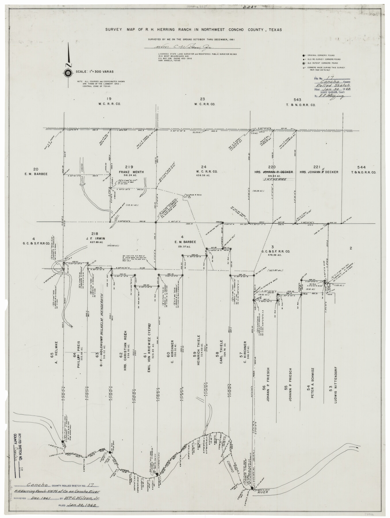
Concho County Rolled Sketch 17
Survey map of R.H. Herring Ranch in northwest Concho County, Texas
-
Map/Doc
78462
-
Collection
General Map Collection
-
Object Dates
1961 (Creation Date)
1962/1/30 (File Date)
-
People and Organizations
Wm. C. Wilson, Jr. (Surveyor/Engineer)
-
Counties
Concho
-
Subjects
Surveying Rolled Sketch
-
Height x Width
35.2 x 26.5 inches
89.4 x 67.3 cm
-
Medium
mylar, print
-
Scale
1" = 300 varas
Part of: General Map Collection
San Jacinto County Working Sketch 35

Print $20.00
- Digital $50.00
San Jacinto County Working Sketch 35
1955
Size 31.3 x 32.1 inches
Map/Doc 63748
Kent County Working Sketch 7

Print $20.00
- Digital $50.00
Kent County Working Sketch 7
1952
Size 32.7 x 23.7 inches
Map/Doc 70014
Scurry County Sketch File 3

Print $20.00
- Digital $50.00
Scurry County Sketch File 3
Size 22.0 x 24.2 inches
Map/Doc 12312
Flight Mission No. BQY-4M, Frame 59, Harris County

Print $20.00
- Digital $50.00
Flight Mission No. BQY-4M, Frame 59, Harris County
1953
Size 18.5 x 22.3 inches
Map/Doc 85268
Lipscomb County Rolled Sketch 5

Print $40.00
- Digital $50.00
Lipscomb County Rolled Sketch 5
Size 61.8 x 8.1 inches
Map/Doc 10640
Flight Mission No. DAG-18K, Frame 187, Matagorda County

Print $20.00
- Digital $50.00
Flight Mission No. DAG-18K, Frame 187, Matagorda County
1952
Size 16.2 x 15.8 inches
Map/Doc 86379
Comanche County Sketch File 22

Print $4.00
- Digital $50.00
Comanche County Sketch File 22
1873
Size 15.2 x 9.2 inches
Map/Doc 19106
The Great Texas Coastal Birding Trail, Central Texas Coast

The Great Texas Coastal Birding Trail, Central Texas Coast
Size 33.3 x 36.0 inches
Map/Doc 94340
Crockett County Working Sketch 94

Print $20.00
- Digital $50.00
Crockett County Working Sketch 94
1979
Size 43.1 x 28.7 inches
Map/Doc 68427
Menard County Sketch File 22

Print $8.00
- Digital $50.00
Menard County Sketch File 22
1927
Size 7.4 x 8.6 inches
Map/Doc 31553
Liberty County Sketch File 23

Print $4.00
- Digital $50.00
Liberty County Sketch File 23
1859
Size 10.0 x 8.2 inches
Map/Doc 29934
Presidio County Rolled Sketch 131A

Print $20.00
- Digital $50.00
Presidio County Rolled Sketch 131A
Size 25.5 x 26.3 inches
Map/Doc 10712
You may also like
Limestone County Boundary File 59

Print $34.00
- Digital $50.00
Limestone County Boundary File 59
Size 7.4 x 8.7 inches
Map/Doc 56299

Hunt County Sketch File 49

Print $4.00
- Digital $50.00
Hunt County Sketch File 49
1852
Size 7.3 x 8.9 inches
Map/Doc 27168
Swisher County Boundary File 1

Print $72.00
- Digital $50.00
Swisher County Boundary File 1
Size 9.0 x 4.5 inches
Map/Doc 59075
General Highway Map, Young County, Texas

Print $20.00
General Highway Map, Young County, Texas
1961
Size 18.3 x 24.8 inches
Map/Doc 79720
Kleberg County

Print $20.00
- Digital $50.00
Kleberg County
1913
Size 27.2 x 34.4 inches
Map/Doc 5006
Roberts County Working Sketch 17

Print $20.00
- Digital $50.00
Roberts County Working Sketch 17
1975
Size 36.1 x 37.3 inches
Map/Doc 63543
[Leagues 212- 217, 241- 244, and Vicinity]
![91430, [Leagues 212- 217, 241- 244, and Vicinity], Twichell Survey Records](https://historictexasmaps.com/wmedia_w700/maps/91430-1.tif.jpg)
Print $20.00
- Digital $50.00
[Leagues 212- 217, 241- 244, and Vicinity]
1902
Size 20.6 x 6.4 inches
Map/Doc 91430
[Robertson Co.]
![4488, [Robertson Co.], Maddox Collection](https://historictexasmaps.com/wmedia_w700/maps/4488.tif.jpg)
Print $20.00
- Digital $50.00
[Robertson Co.]
1880
Size 32.3 x 44.3 inches
Map/Doc 4488
Harris County NRC Article 33.136 Sketch 15

Print $28.00
- Digital $50.00
Harris County NRC Article 33.136 Sketch 15
2012
Size 24.0 x 18.0 inches
Map/Doc 94762
Flight Mission No. BRA-8M, Frame 72, Jefferson County

Print $20.00
- Digital $50.00
Flight Mission No. BRA-8M, Frame 72, Jefferson County
1953
Size 18.6 x 22.2 inches
Map/Doc 85592
Flight Mission No. CRC-4R, Frame 70, Chambers County

Print $20.00
- Digital $50.00
Flight Mission No. CRC-4R, Frame 70, Chambers County
1956
Size 18.7 x 22.4 inches
Map/Doc 84874