Presidio County Rolled Sketch 131A
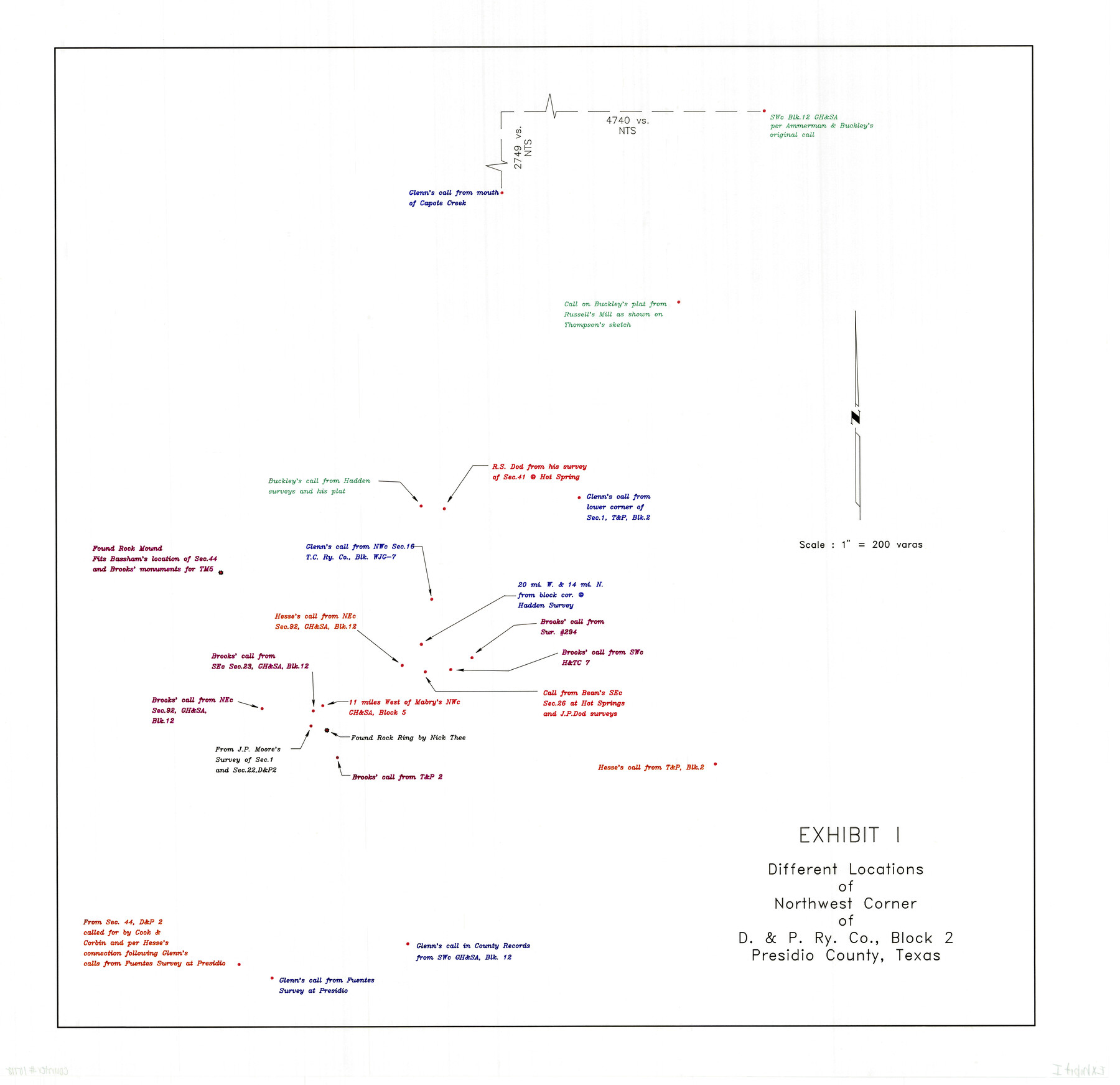
Exhibit I - Different locations of northwest corner of D. & P. Ry. Co. Block 2, Presidio County, Texas
-
Map/Doc
10712
-
Collection
General Map Collection
-
Counties
Presidio
-
Subjects
Surveying Rolled Sketch
-
Height x Width
25.5 x 26.3 inches
64.8 x 66.8 cm
-
Medium
paper, print
-
Scale
1" = 200 varas
-
Comments
See 10706-10713, 9801, and 9802 for all sketches in Presidio County Rolled Sketch 131A. See also Presidio County Sketch File 116 (34842), Presidio County Sketch File 116A (34885), and Presidio County Rolled Sketch 131B (9803) for report, exhibits, and additional sketches.
Related maps
Presidio County Rolled Sketch 131A

Print $20.00
- Digital $50.00
Presidio County Rolled Sketch 131A
1975
Size 30.5 x 24.9 inches
Map/Doc 10706
Presidio County Rolled Sketch 131A

Print $20.00
- Digital $50.00
Presidio County Rolled Sketch 131A
Size 17.5 x 14.1 inches
Map/Doc 10707
Presidio County Rolled Sketch 131A

Print $3.00
- Digital $50.00
Presidio County Rolled Sketch 131A
Size 15.8 x 9.3 inches
Map/Doc 10708
Presidio County Rolled Sketch 131A

Print $3.00
- Digital $50.00
Presidio County Rolled Sketch 131A
Size 14.5 x 9.1 inches
Map/Doc 10709
Presidio County Rolled Sketch 131A

Print $20.00
- Digital $50.00
Presidio County Rolled Sketch 131A
Size 17.7 x 11.9 inches
Map/Doc 10710
Presidio County Rolled Sketch 131A

Print $20.00
- Digital $50.00
Presidio County Rolled Sketch 131A
Size 47.5 x 36.6 inches
Map/Doc 10711
Presidio County Rolled Sketch 131A

Print $40.00
- Digital $50.00
Presidio County Rolled Sketch 131A
1991
Size 37.6 x 49.7 inches
Map/Doc 10713
Presidio County Sketch File 116

Print $86.00
- Digital $50.00
Presidio County Sketch File 116
1993
Size 11.4 x 8.7 inches
Map/Doc 34842
Presidio County Sketch File 116A

Print $63.00
- Digital $50.00
Presidio County Sketch File 116A
Size 17.0 x 11.0 inches
Map/Doc 34885
Presidio County Rolled Sketch 131A

Print $20.00
- Digital $50.00
Presidio County Rolled Sketch 131A
1992
Size 36.0 x 45.5 inches
Map/Doc 9801
Presidio County Rolled Sketch 131A

Print $20.00
- Digital $50.00
Presidio County Rolled Sketch 131A
1992
Size 36.5 x 46.7 inches
Map/Doc 9802
Presidio County Rolled Sketch 131B

Print $20.00
- Digital $50.00
Presidio County Rolled Sketch 131B
1993
Size 33.4 x 46.7 inches
Map/Doc 9803
Part of: General Map Collection

Map of Lavaca County
Print $20.00
- Digital $50.00
Map of Lavaca County
1866
Size 22.3 x 23.7 inches
Map/Doc 3802
Current Miscellaneous File 83

Print $2.00
- Digital $50.00
Current Miscellaneous File 83
1936
Size 8.3 x 10.6 inches
Map/Doc 74226
Wharton County Working Sketch 1

Print $20.00
- Digital $50.00
Wharton County Working Sketch 1
Size 23.3 x 21.4 inches
Map/Doc 72465
Webb County Working Sketch 10

Print $20.00
- Digital $50.00
Webb County Working Sketch 10
1913
Size 23.7 x 20.0 inches
Map/Doc 72375
Travis County

Print $40.00
- Digital $50.00
Travis County
1880
Size 61.7 x 24.0 inches
Map/Doc 87934
Roberts County Working Sketch 7

Print $20.00
- Digital $50.00
Roberts County Working Sketch 7
1954
Size 25.1 x 33.3 inches
Map/Doc 63533
Trinity County Sketch File 37

Print $4.00
- Digital $50.00
Trinity County Sketch File 37
1921
Size 11.3 x 8.8 inches
Map/Doc 38591
Dallam County

Print $20.00
- Digital $50.00
Dallam County
1926
Size 34.0 x 41.0 inches
Map/Doc 77257

Matagorda County NRC Article 33.136 Sketch 9

Print $28.00
- Digital $50.00
Matagorda County NRC Article 33.136 Sketch 9
2011
Size 24.0 x 36.0 inches
Map/Doc 94811
Flight Mission No. BRA-7M, Frame 201, Jefferson County

Print $20.00
- Digital $50.00
Flight Mission No. BRA-7M, Frame 201, Jefferson County
1953
Size 18.6 x 22.4 inches
Map/Doc 85569
You may also like
[Sketch in vicinity of Wm. McCutcheon, S. H. Reid and John McGinley]
![90115, [Sketch in vicinity of Wm. McCutcheon, S. H. Reid and John McGinley], Twichell Survey Records](https://historictexasmaps.com/wmedia_w700/maps/90115-1.tif.jpg)
Print $20.00
- Digital $50.00
[Sketch in vicinity of Wm. McCutcheon, S. H. Reid and John McGinley]
1923
Size 20.0 x 13.2 inches
Map/Doc 90115
Victoria County Rolled Sketch 4A

Print $40.00
- Digital $50.00
Victoria County Rolled Sketch 4A
Size 66.4 x 43.9 inches
Map/Doc 10095
[T. & P. Blocks 33 and 34, Township 5N]
![90638, [T. & P. Blocks 33 and 34, Township 5N], Twichell Survey Records](https://historictexasmaps.com/wmedia_w700/maps/90638-1.tif.jpg)
Print $20.00
- Digital $50.00
[T. & P. Blocks 33 and 34, Township 5N]
Size 30.7 x 20.8 inches
Map/Doc 90638
Map of Texas and Parts of Adjoining Territories

Print $20.00
Map of Texas and Parts of Adjoining Territories
1899
Size 33.7 x 36.0 inches
Map/Doc 79304

Flight Mission No. DAG-18K, Frame 184, Matagorda County

Print $20.00
- Digital $50.00
Flight Mission No. DAG-18K, Frame 184, Matagorda County
1952
Size 18.6 x 22.4 inches
Map/Doc 86376
Sketch in Terry & Yoakum Counties

Print $20.00
- Digital $50.00
Sketch in Terry & Yoakum Counties
1945
Size 21.8 x 40.0 inches
Map/Doc 92854
Scarborough's Map of the New England States Vermont, New Hampshire, Maine, Massachusetts, Rhode Island and Connecticut

Print $40.00
- Digital $50.00
Scarborough's Map of the New England States Vermont, New Hampshire, Maine, Massachusetts, Rhode Island and Connecticut
1910
Size 58.3 x 40.1 inches
Map/Doc 97106
Presidio County Rolled Sketch 130

Print $40.00
- Digital $50.00
Presidio County Rolled Sketch 130
1993
Size 33.6 x 49.1 inches
Map/Doc 9800
Map of the Property traversed by the Trinity & Sabine Railroad from Fortieth Mile to Ogden, Texas

Print $40.00
- Digital $50.00
Map of the Property traversed by the Trinity & Sabine Railroad from Fortieth Mile to Ogden, Texas
1882
Size 39.5 x 93.2 inches
Map/Doc 64046
Dallam County Working Sketch 1

Print $20.00
- Digital $50.00
Dallam County Working Sketch 1
1905
Size 15.9 x 13.6 inches
Map/Doc 68586
[Sketch showing counties along Texas-New Mexico border]
![91987, [Sketch showing counties along Texas-New Mexico border], Twichell Survey Records](https://historictexasmaps.com/wmedia_w700/maps/91987-1.tif.jpg)
Print $20.00
- Digital $50.00
[Sketch showing counties along Texas-New Mexico border]
Size 12.4 x 17.5 inches
Map/Doc 91987