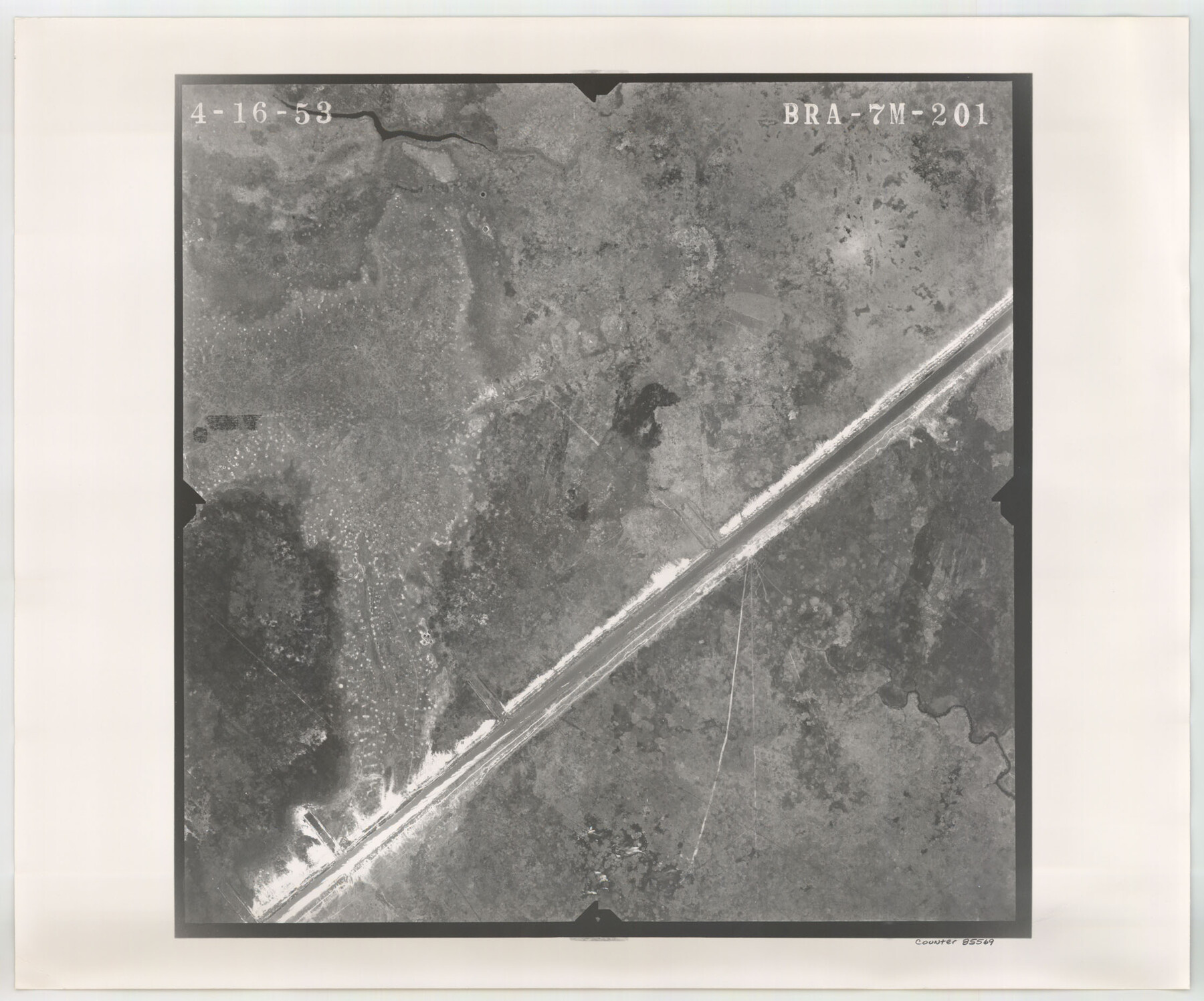
Flight Mission No. BRA-7M, Frame 201, Jefferson County
BRA-7M-201
-
Map/Doc
85569
-
Collection
General Map Collection
-
Object Dates
1953/4/16 (Creation Date)
-
People and Organizations
U. S. Department of Agriculture (Publisher)
-
Counties
Jefferson
-
Subjects
Aerial Photograph
-
Height x Width
18.6 x 22.4 inches
47.2 x 56.9 cm
-
Comments
Flown by Jack Ammann Photogrammetric Engineers of San Antonio, Texas.
Part of: General Map Collection
Sketch of a portion of the Texas Coast showing the relative positions of different harbours with the interior Military Posts, and the roads communicating with them, also two new routes from Black Point and Lamar to San Antonio

Print $20.00
- Digital $50.00
Sketch of a portion of the Texas Coast showing the relative positions of different harbours with the interior Military Posts, and the roads communicating with them, also two new routes from Black Point and Lamar to San Antonio
1855
Size 27.3 x 18.3 inches
Map/Doc 72709
Tom Green County Rolled Sketch 22

Print $20.00
- Digital $50.00
Tom Green County Rolled Sketch 22
1966
Size 38.0 x 43.6 inches
Map/Doc 10006
Jasper County Working Sketch 8

Print $20.00
- Digital $50.00
Jasper County Working Sketch 8
1915
Size 20.1 x 31.4 inches
Map/Doc 66470
[Map of a portion of Bexar and Travis Districts]
![16943, [Map of a portion of Bexar and Travis Districts], General Map Collection](https://historictexasmaps.com/wmedia_w700/maps/16943.tif.jpg)
Print $20.00
- Digital $50.00
[Map of a portion of Bexar and Travis Districts]
Size 47.5 x 47.2 inches
Map/Doc 16943
Bee County Sketch File 2a

Print $6.00
- Digital $50.00
Bee County Sketch File 2a
1847
Size 7.9 x 13.0 inches
Map/Doc 14356
[Sketch for Mineral Application 21493 - Clay County]
![65626, [Sketch for Mineral Application 21493 - Clay County], General Map Collection](https://historictexasmaps.com/wmedia_w700/maps/65626-1.tif.jpg)
Print $40.00
- Digital $50.00
[Sketch for Mineral Application 21493 - Clay County]
Size 63.1 x 35.3 inches
Map/Doc 65626

Comal County Rolled Sketch 6

Print $4.00
- Digital $50.00
Comal County Rolled Sketch 6
1988
Size 25.0 x 19.1 inches
Map/Doc 5541
Flight Mission No. DQO-3K, Frame 79, Galveston County

Print $20.00
- Digital $50.00
Flight Mission No. DQO-3K, Frame 79, Galveston County
1952
Size 18.9 x 22.5 inches
Map/Doc 85084
Flight Mission No. CGN-3P, Frame 22, San Patricio County

Print $20.00
- Digital $50.00
Flight Mission No. CGN-3P, Frame 22, San Patricio County
1956
Size 18.6 x 22.3 inches
Map/Doc 86980
Edwards County Working Sketch 137

Print $20.00
- Digital $50.00
Edwards County Working Sketch 137
1997
Size 33.2 x 34.3 inches
Map/Doc 69013

You may also like
J. B. McCauley Farm NW Quarter Section 30, Block A

Print $20.00
- Digital $50.00
J. B. McCauley Farm NW Quarter Section 30, Block A
Size 16.4 x 18.8 inches
Map/Doc 92315
Panola County Working Sketch 7

Print $20.00
- Digital $50.00
Panola County Working Sketch 7
1942
Map/Doc 71416
General Highway Map, Sherman County, Texas

Print $20.00
General Highway Map, Sherman County, Texas
1961
Size 18.2 x 24.8 inches
Map/Doc 79653
Marion County Working Sketch 11

Print $20.00
- Digital $50.00
Marion County Working Sketch 11
1952
Size 23.8 x 28.7 inches
Map/Doc 70786
Leon County Working Sketch 33

Print $20.00
- Digital $50.00
Leon County Working Sketch 33
1978
Size 43.4 x 41.6 inches
Map/Doc 70432
Somervell County Sketch File 3

Print $6.00
- Digital $50.00
Somervell County Sketch File 3
1858
Size 8.2 x 3.9 inches
Map/Doc 36797
Flight Mission No. CRC-4R, Frame 76, Chambers County

Print $20.00
- Digital $50.00
Flight Mission No. CRC-4R, Frame 76, Chambers County
1956
Size 18.8 x 22.4 inches
Map/Doc 84880
Brooks County Sketch File 5

Print $18.00
- Digital $50.00
Brooks County Sketch File 5
1941
Size 11.3 x 9.0 inches
Map/Doc 16551
Presidio County Sketch File 66

Print $6.00
- Digital $50.00
Presidio County Sketch File 66
1940
Size 11.4 x 8.7 inches
Map/Doc 34656
Culberson County Sketch [showing PSL Blocks 109-111, 113-115 and University Block 46]
![90500, Culberson County Sketch [showing PSL Blocks 109-111, 113-115 and University Block 46], Twichell Survey Records](https://historictexasmaps.com/wmedia_w700/maps/90500-1.tif.jpg)
Print $20.00
- Digital $50.00
Culberson County Sketch [showing PSL Blocks 109-111, 113-115 and University Block 46]
Size 25.8 x 12.7 inches
Map/Doc 90500
1968 Texas Official State Highway Map

Digital $50.00
1968 Texas Official State Highway Map
Size 28.1 x 36.5 inches
Map/Doc 94319
Crockett County Sketch File 22

Print $12.00
- Digital $50.00
Crockett County Sketch File 22
1881
Size 13.1 x 8.1 inches
Map/Doc 19691