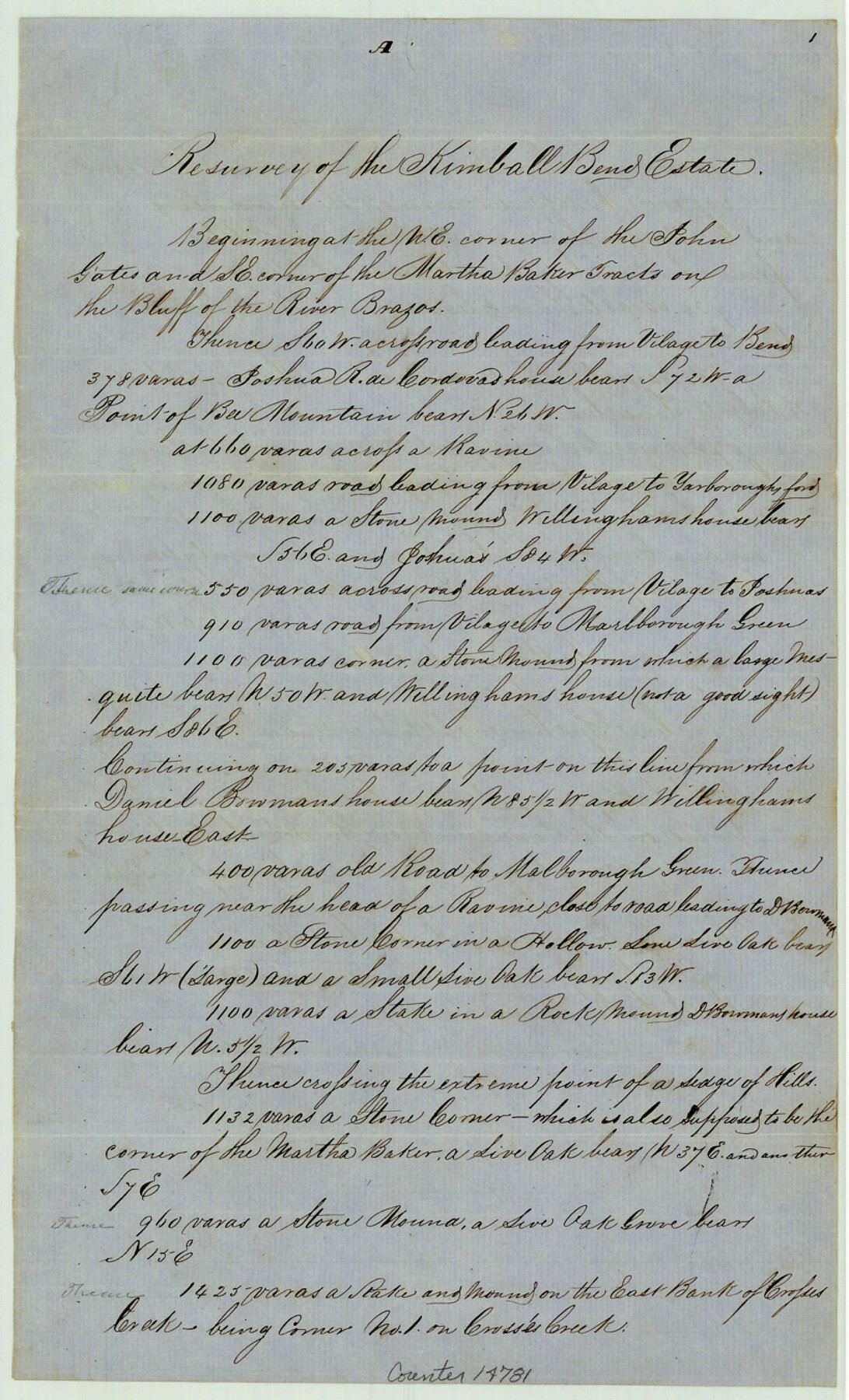
Bosque County Sketch File 16
[Field notes of connecting lines between Martha Baker league and James H. Raymond survey on the Brazos River]
-
Map/Doc
14781
-
Collection
General Map Collection
-
Object Dates
1863/4/21 (File Date)
-
People and Organizations
J. De Cordova (Surveyor/Engineer)
Henry M. De Cordova (Surveyor/Engineer)
-
Counties
Bosque
-
Subjects
Surveying Sketch File
-
Height x Width
13.0 x 7.9 inches
33.0 x 20.1 cm
-
Medium
paper, manuscript
-
Features
Road from Powell's to Harlan's Ranch
Spring Creek
Bee Branch of Mesquite Creek]
New Meredian [sic] Road
Sycamore Branch [of Mesquite Creek]
Old Meredian [sic] Road
Road from Powell's to Bible's
Mesquite Creek
Old Corn Roads
Brazos River
Cross's Creek
Road to D. Bowman's
Road from Vilage to Marlborough Green [house]
Road from Vilage to Joshua's house
Yarborough Ford
Bee Mountain
Bend Road
Road from Vilage to Bend
Part of: General Map Collection
Upton County Working Sketch 18

Print $20.00
- Digital $50.00
Upton County Working Sketch 18
1945
Size 19.7 x 19.9 inches
Map/Doc 69514
Pecos County Rolled Sketch 22

Print $20.00
- Digital $50.00
Pecos County Rolled Sketch 22
1886
Size 24.3 x 37.0 inches
Map/Doc 93455
Guadalupe County Sketch File 21

Print $6.00
- Digital $50.00
Guadalupe County Sketch File 21
Size 9.9 x 8.5 inches
Map/Doc 24702
San Saba County Rolled Sketch 1

Print $3.00
- Digital $50.00
San Saba County Rolled Sketch 1
Size 11.7 x 9.0 inches
Map/Doc 7742
Fractional Township No. 7 South Range No. 6 West of the Indian Meridian, Indian Territory

Print $20.00
- Digital $50.00
Fractional Township No. 7 South Range No. 6 West of the Indian Meridian, Indian Territory
1898
Size 19.2 x 24.2 inches
Map/Doc 75188
Report of a resurvey of Texas & Pacific Ry. Lands in the 80 mile reservation made in 1930-31 for Kloh, Rumsey, and Abrams by W. J. Powell, Consulting Eng.

Print $77.00
- Digital $50.00
Report of a resurvey of Texas & Pacific Ry. Lands in the 80 mile reservation made in 1930-31 for Kloh, Rumsey, and Abrams by W. J. Powell, Consulting Eng.
1931
Size 11.3 x 8.8 inches
Map/Doc 2247
Newton County Rolled Sketch 15

Print $20.00
- Digital $50.00
Newton County Rolled Sketch 15
1953
Size 26.0 x 43.7 inches
Map/Doc 6845
Coke County Sketch File 2

Print $22.00
- Digital $50.00
Coke County Sketch File 2
Size 9.1 x 7.8 inches
Map/Doc 18565
[Galveston, Harrisburg & San Antonio Railroad from Cuero to Stockdale]
![64192, [Galveston, Harrisburg & San Antonio Railroad from Cuero to Stockdale], General Map Collection](https://historictexasmaps.com/wmedia_w700/maps/64192.tif.jpg)
Print $20.00
- Digital $50.00
[Galveston, Harrisburg & San Antonio Railroad from Cuero to Stockdale]
1907
Size 14.1 x 34.1 inches
Map/Doc 64192
Trinity River, Carl Switch Sheet/Chambers Creek

Print $4.00
- Digital $50.00
Trinity River, Carl Switch Sheet/Chambers Creek
1926
Size 27.9 x 27.0 inches
Map/Doc 65217
El Paso County Boundary File 24

Print $32.00
- Digital $50.00
El Paso County Boundary File 24
Size 14.8 x 9.6 inches
Map/Doc 53221
A Geographically Correct Map of the State of Texas

Print $20.00
- Digital $50.00
A Geographically Correct Map of the State of Texas
1876
Size 20.0 x 21.5 inches
Map/Doc 93397
You may also like
Gray County Boundary File 6

Print $6.00
- Digital $50.00
Gray County Boundary File 6
Size 10.9 x 7.3 inches
Map/Doc 53895
Atascosa County Boundary File 6

Print $34.00
- Digital $50.00
Atascosa County Boundary File 6
Size 9.1 x 23.0 inches
Map/Doc 50205
Flight Mission No. DIX-6P, Frame 128, Aransas County

Print $20.00
- Digital $50.00
Flight Mission No. DIX-6P, Frame 128, Aransas County
1956
Size 19.2 x 22.6 inches
Map/Doc 83834
General Highway Map, Loving County, Texas

Print $20.00
General Highway Map, Loving County, Texas
1961
Size 18.1 x 24.6 inches
Map/Doc 79577
Colorado County Sketch File 28

Print $17.00
- Digital $50.00
Colorado County Sketch File 28
1935
Size 9.1 x 7.7 inches
Map/Doc 18966
Marion County Working Sketch 45

Print $20.00
- Digital $50.00
Marion County Working Sketch 45
2005
Size 27.0 x 29.2 inches
Map/Doc 83576
Northern Part of Laguna Madre

Print $20.00
- Digital $50.00
Northern Part of Laguna Madre
1946
Size 43.8 x 34.5 inches
Map/Doc 73523
Montgomery County Working Sketch 25

Print $40.00
- Digital $50.00
Montgomery County Working Sketch 25
1941
Size 50.0 x 43.7 inches
Map/Doc 71132
Reagan County Sketch File 22

Print $6.00
- Digital $50.00
Reagan County Sketch File 22
1939
Size 11.4 x 8.9 inches
Map/Doc 35013
Dimmit County Working Sketch 11

Print $20.00
- Digital $50.00
Dimmit County Working Sketch 11
1935
Size 28.7 x 31.7 inches
Map/Doc 68672
Map of Robertson District

Print $40.00
- Digital $50.00
Map of Robertson District
1846
Size 81.3 x 45.3 inches
Map/Doc 3032
Map of Hidalgo County

Print $20.00
- Digital $50.00
Map of Hidalgo County
1880
Size 45.3 x 25.1 inches
Map/Doc 3667