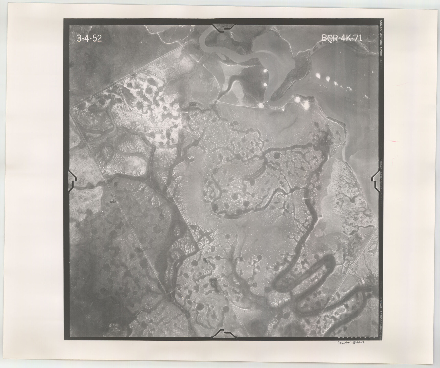
Flight Mission No. BQR-4K, Frame 71, Brazoria County
BQR-4K-71
-
Map/Doc
84004
-
Collection
General Map Collection
-
Object Dates
1952/3/4 (Creation Date)
-
People and Organizations
U. S. Department of Agriculture (Publisher)
-
Counties
Brazoria
-
Subjects
Aerial Photograph
-
Height x Width
18.8 x 22.4 inches
47.8 x 56.9 cm
-
Comments
Flown by Aero Exploration Company of Tulsa, Oklahoma.
Part of: General Map Collection
Pecos County Rolled Sketch 42

Print $20.00
- Digital $50.00
Pecos County Rolled Sketch 42
1909
Size 19.6 x 41.0 inches
Map/Doc 7220
Galveston County Rolled Sketch 45A

Print $20.00
- Digital $50.00
Galveston County Rolled Sketch 45A
1995
Size 19.6 x 29.9 inches
Map/Doc 5979
Jack County Sketch File 7

Print $6.00
- Digital $50.00
Jack County Sketch File 7
1857
Size 6.7 x 12.4 inches
Map/Doc 27516
Map of Brassos [sic] & Bosque Surveys
![146, Map of Brassos [sic] & Bosque Surveys, General Map Collection](https://historictexasmaps.com/wmedia_w700/maps/146.tif.jpg)
Print $20.00
- Digital $50.00
Map of Brassos [sic] & Bosque Surveys
1841
Size 27.7 x 18.9 inches
Map/Doc 146
Terrell County Working Sketch 50

Print $40.00
- Digital $50.00
Terrell County Working Sketch 50
1958
Size 43.0 x 64.3 inches
Map/Doc 62143
Fisher County Boundary File 1

Print $16.00
- Digital $50.00
Fisher County Boundary File 1
Size 12.8 x 8.4 inches
Map/Doc 53411
FT. W. & R. G. Ry. Right of Way Map, Whiteland to Lightner, Concho County, Texas

Print $40.00
- Digital $50.00
FT. W. & R. G. Ry. Right of Way Map, Whiteland to Lightner, Concho County, Texas
1918
Size 37.5 x 68.4 inches
Map/Doc 61413
Howard County Working Sketch 9a

Print $20.00
- Digital $50.00
Howard County Working Sketch 9a
1962
Size 34.8 x 32.8 inches
Map/Doc 66276
Garza County Sketch File 11

Print $4.00
- Digital $50.00
Garza County Sketch File 11
1901
Size 11.3 x 8.8 inches
Map/Doc 24066
Leon County Working Sketch 21

Print $20.00
- Digital $50.00
Leon County Working Sketch 21
1964
Size 20.9 x 22.9 inches
Map/Doc 70420
Montgomery County

Print $20.00
- Digital $50.00
Montgomery County
1895
Size 21.6 x 24.8 inches
Map/Doc 3897
Cooke County Sketch File 40

Print $20.00
- Digital $50.00
Cooke County Sketch File 40
Size 36.3 x 34.0 inches
Map/Doc 10341
You may also like
Culberson County Working Sketch 3

Print $40.00
- Digital $50.00
Culberson County Working Sketch 3
Size 50.6 x 21.1 inches
Map/Doc 68455
A Map of Dallas County

Print $20.00
- Digital $50.00
A Map of Dallas County
1854
Size 20.9 x 16.6 inches
Map/Doc 4526
Central Part of Jeff Davis Co.

Print $40.00
- Digital $50.00
Central Part of Jeff Davis Co.
1982
Size 54.2 x 41.6 inches
Map/Doc 77326
Flight Mission No. BRA-16M, Frame 146, Jefferson County

Print $20.00
- Digital $50.00
Flight Mission No. BRA-16M, Frame 146, Jefferson County
1953
Size 18.4 x 22.3 inches
Map/Doc 85752
[Notes and rough sketch of survey 6, Block 16 and survey 19 1/2, Block 19]
![93052, [Notes and rough sketch of survey 6, Block 16 and survey 19 1/2, Block 19], Twichell Survey Records](https://historictexasmaps.com/wmedia_w700/maps/93052-1.tif.jpg)
Print $2.00
- Digital $50.00
[Notes and rough sketch of survey 6, Block 16 and survey 19 1/2, Block 19]
1937
Size 8.7 x 11.4 inches
Map/Doc 93052
Duval County Sketch File 22

Print $20.00
- Digital $50.00
Duval County Sketch File 22
1880
Size 31.9 x 23.2 inches
Map/Doc 11386
Crockett County Working Sketch 26

Print $20.00
- Digital $50.00
Crockett County Working Sketch 26
1922
Size 15.3 x 20.3 inches
Map/Doc 68359
General Highway Map, Jefferson County, Texas

Print $20.00
General Highway Map, Jefferson County, Texas
1961
Size 24.6 x 18.3 inches
Map/Doc 79537
Newton County Working Sketch 11

Print $20.00
- Digital $50.00
Newton County Working Sketch 11
1941
Size 22.7 x 23.5 inches
Map/Doc 71257
Outer Continental Shelf Leasing Maps (Texas Offshore Operations)

Print $20.00
- Digital $50.00
Outer Continental Shelf Leasing Maps (Texas Offshore Operations)
Size 24.0 x 18.4 inches
Map/Doc 75853
Matagorda County Working Sketch 14

Print $40.00
- Digital $50.00
Matagorda County Working Sketch 14
1950
Size 42.9 x 50.5 inches
Map/Doc 70872
Dallas County Sketch File 12

Print $20.00
- Digital $50.00
Dallas County Sketch File 12
1853
Size 25.4 x 25.2 inches
Map/Doc 11284