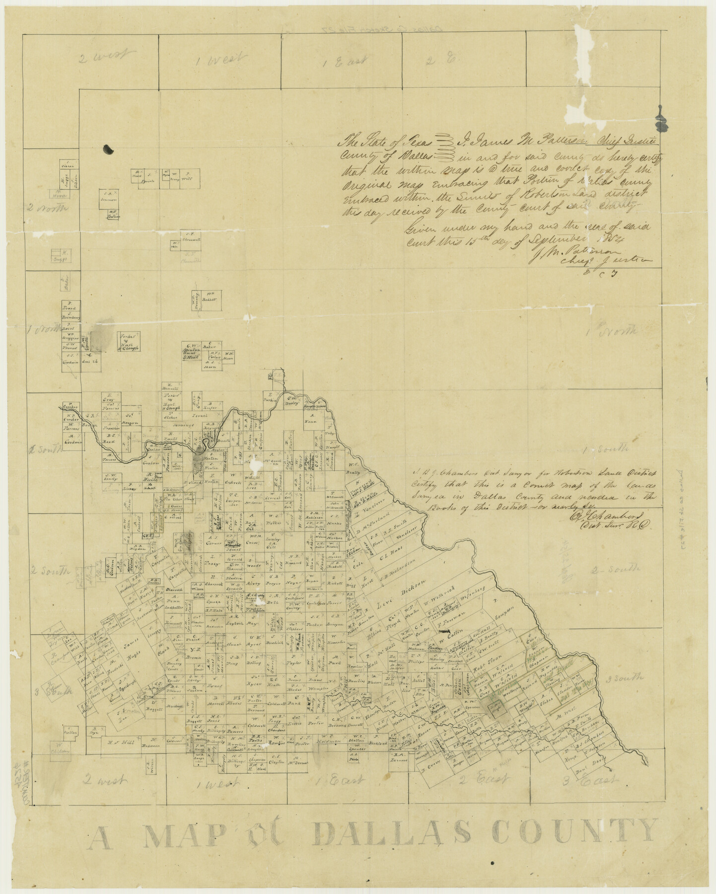
A Map of Dallas County
Dallas County Sketch File 27
-
Map/Doc
4526
-
Collection
General Map Collection
-
Object Dates
9/15/1854 (Creation Date)
11/21/1984 (File Date)
-
People and Organizations
Murphy and Bolenz (Publisher)
J.H. Swindells (Draftsman)
B.J. Chambers (Surveyor/Engineer)
-
Counties
Dallas
-
Subjects
County
-
Height x Width
20.9 x 16.6 inches
53.1 x 42.2 cm
-
Comments
In two parts; see counter no. 4525 for first part.
Received in office September 25, 1854.
Conservation funded in 2002 with donation from Davis, Clark and Company.
Part of: General Map Collection
Garza County Rolled Sketch P

Print $20.00
- Digital $50.00
Garza County Rolled Sketch P
1914
Size 21.3 x 23.3 inches
Map/Doc 6005
Mitchell County Boundary File 66a

Print $11.00
- Digital $50.00
Mitchell County Boundary File 66a
Size 12.6 x 8.3 inches
Map/Doc 57378
Hardin County Rolled Sketch 10

Print $20.00
- Digital $50.00
Hardin County Rolled Sketch 10
1948
Size 23.7 x 33.0 inches
Map/Doc 6082
Guadalupe County Sketch File 4

Print $4.00
- Digital $50.00
Guadalupe County Sketch File 4
1869
Size 8.2 x 7.9 inches
Map/Doc 24654
Pecos County Sketch File 68

Print $6.00
- Digital $50.00
Pecos County Sketch File 68
1920
Size 14.4 x 8.8 inches
Map/Doc 33866
Bee County Working Sketch 30

Print $20.00
- Digital $50.00
Bee County Working Sketch 30
1950
Size 12.7 x 15.7 inches
Map/Doc 67281
Liberty County Rolled Sketch R

Print $40.00
- Digital $50.00
Liberty County Rolled Sketch R
Size 51.7 x 36.5 inches
Map/Doc 10656
McMullen County Rolled Sketch 17

Print $40.00
- Digital $50.00
McMullen County Rolled Sketch 17
1950
Map/Doc 9501
Bastrop County Rolled Sketch 5

Print $20.00
- Digital $50.00
Bastrop County Rolled Sketch 5
2013
Size 24.9 x 36.9 inches
Map/Doc 93715
El Nuevo Mexico y Tierras Adyacentes Mapa Levantado para la demarcacion de los Limites de los Dominios Españoles y de los Estados Unidos

El Nuevo Mexico y Tierras Adyacentes Mapa Levantado para la demarcacion de los Limites de los Dominios Españoles y de los Estados Unidos
1811
Size 27.9 x 36.6 inches
Map/Doc 97483
Brewster County Rolled Sketch 133

Print $20.00
- Digital $50.00
Brewster County Rolled Sketch 133
1979
Size 30.8 x 36.8 inches
Map/Doc 8524

You may also like
Chambers County Sketch File 48

Print $88.00
- Digital $50.00
Chambers County Sketch File 48
1925
Size 14.3 x 8.8 inches
Map/Doc 18002
Presidio County Rolled Sketch 57

Print $20.00
- Digital $50.00
Presidio County Rolled Sketch 57
1915
Size 22.8 x 17.3 inches
Map/Doc 7350
Falls County Sketch File 29

Print $40.00
- Digital $50.00
Falls County Sketch File 29
Size 19.9 x 23.5 inches
Map/Doc 75994
Tarrant County Working Sketch 27

Print $20.00
- Digital $50.00
Tarrant County Working Sketch 27
2010
Size 19.4 x 35.9 inches
Map/Doc 89261
Flight Mission No. BRE-2P, Frame 50, Nueces County

Print $20.00
- Digital $50.00
Flight Mission No. BRE-2P, Frame 50, Nueces County
1956
Size 18.5 x 22.4 inches
Map/Doc 86752
Texas Panhandle East Boundary Line

Print $40.00
- Digital $50.00
Texas Panhandle East Boundary Line
1898
Size 9.2 x 64.9 inches
Map/Doc 1716
Matagorda County Rolled Sketch 9

Print $20.00
- Digital $50.00
Matagorda County Rolled Sketch 9
Size 36.8 x 30.0 inches
Map/Doc 6680
General Highway Map, El Paso County, Texas

Print $20.00
General Highway Map, El Paso County, Texas
1961
Size 18.4 x 24.6 inches
Map/Doc 79455
Tom Green County

Print $40.00
- Digital $50.00
Tom Green County
1942
Size 55.4 x 47.6 inches
Map/Doc 63073
Chambers County Working Sketch 20

Print $20.00
- Digital $50.00
Chambers County Working Sketch 20
1973
Size 25.8 x 30.2 inches
Map/Doc 68003
General Highway Map, Brazos County, Texas

Print $20.00
General Highway Map, Brazos County, Texas
1940
Size 25.2 x 18.5 inches
Map/Doc 79026
Pecos County Working Sketch Graphic Index - south part

Print $20.00
- Digital $50.00
Pecos County Working Sketch Graphic Index - south part
1976
Size 35.3 x 43.2 inches
Map/Doc 76665