Brewster County Rolled Sketch 133
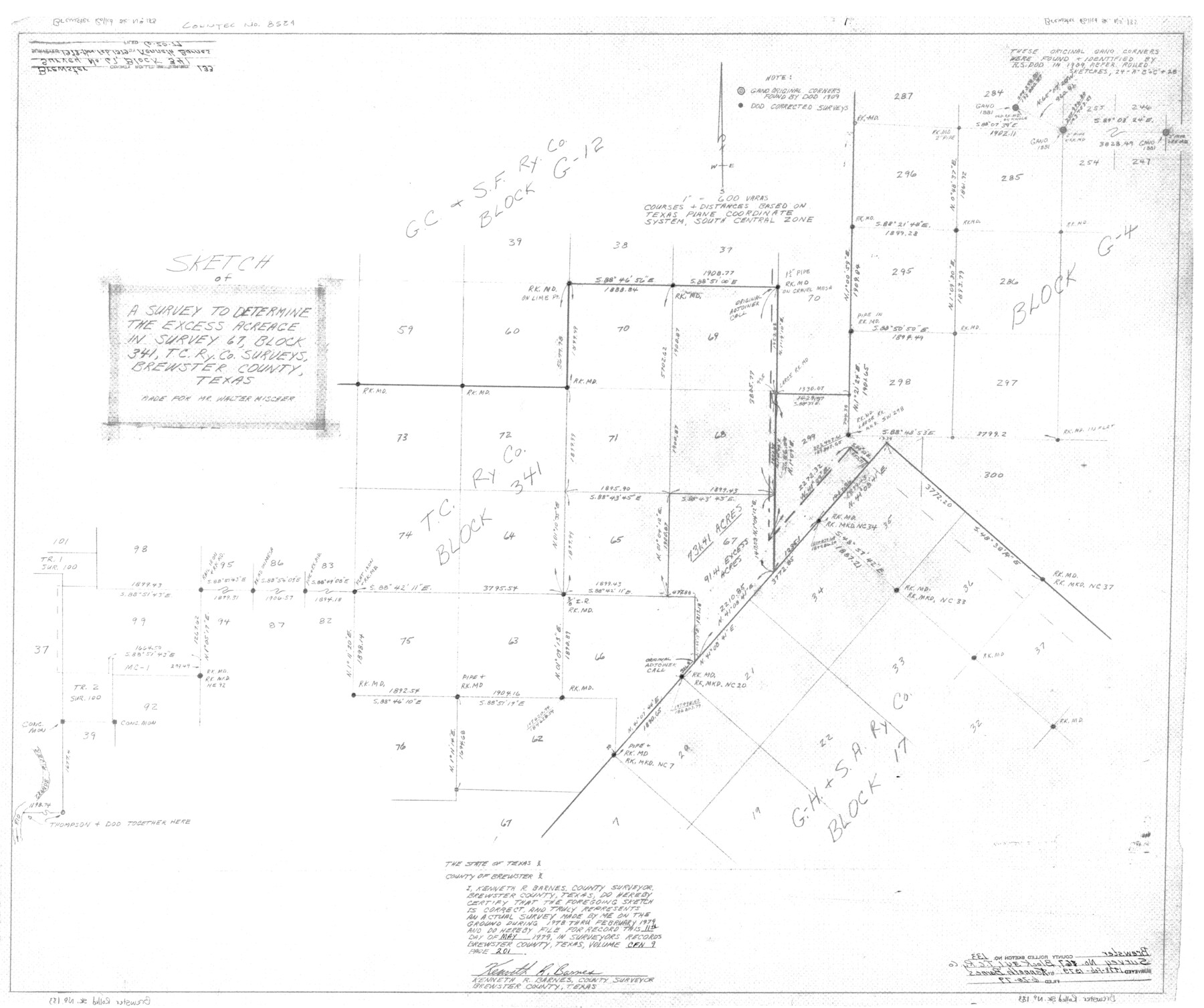
Sketch of a survey to determine the excess acreage in survey 67, Block 341, T. C. Ry. Co. surveys, Brewster County, Texas made for Mr. Walter Mischer
-
Map/Doc
8524
-
Collection
General Map Collection
-
Object Dates
1979 (Survey Date)
1979/6/20 (File Date)
1979/5/11 (Creation Date)
-
People and Organizations
Kenneth R. Barnes (Surveyor/Engineer)
-
Counties
Brewster
-
Subjects
Surveying Rolled Sketch
-
Height x Width
30.8 x 36.8 inches
78.2 x 93.5 cm
Part of: General Map Collection
Brewster County Working Sketch 70

Print $20.00
- Digital $50.00
Brewster County Working Sketch 70
1961
Size 30.5 x 44.0 inches
Map/Doc 67671
Val Verde County Working Sketch 7

Print $20.00
- Digital $50.00
Val Verde County Working Sketch 7
1915
Size 21.9 x 19.5 inches
Map/Doc 72142
Lampasas County Working Sketch 21

Print $20.00
- Digital $50.00
Lampasas County Working Sketch 21
1988
Size 15.2 x 26.7 inches
Map/Doc 70299
Map of Henderson County

Print $20.00
- Digital $50.00
Map of Henderson County
1871
Size 16.3 x 30.3 inches
Map/Doc 4563
Garza County Rolled Sketch R3

Print $20.00
- Digital $50.00
Garza County Rolled Sketch R3
Size 21.4 x 14.9 inches
Map/Doc 6006
Bell County Sketch File 20a

Print $4.00
- Digital $50.00
Bell County Sketch File 20a
1855
Size 6.7 x 8.3 inches
Map/Doc 14408
Blanco County Sketch File 23

Print $16.00
- Digital $50.00
Blanco County Sketch File 23
1887
Size 8.7 x 14.1 inches
Map/Doc 14606
El Paso County Working Sketch 39

Print $20.00
- Digital $50.00
El Paso County Working Sketch 39
1984
Size 45.7 x 37.1 inches
Map/Doc 69061
Hartley County Sketch File 16

Print $4.00
- Digital $50.00
Hartley County Sketch File 16
Size 11.1 x 7.1 inches
Map/Doc 26113
[Texas & Pacific Railway through Callahan County]
![64236, [Texas & Pacific Railway through Callahan County], General Map Collection](https://historictexasmaps.com/wmedia_w700/maps/64236.tif.jpg)
Print $20.00
- Digital $50.00
[Texas & Pacific Railway through Callahan County]
1918
Size 22.9 x 8.8 inches
Map/Doc 64236
Jefferson Co.

Print $40.00
- Digital $50.00
Jefferson Co.
1978
Size 49.3 x 43.5 inches
Map/Doc 95546
Dimmit County Sketch File 59

Print $26.00
- Digital $50.00
Dimmit County Sketch File 59
1912
Size 14.4 x 8.9 inches
Map/Doc 21193
You may also like
Stephens County Sketch File 7

Print $4.00
- Digital $50.00
Stephens County Sketch File 7
1875
Size 8.1 x 9.9 inches
Map/Doc 37025
Cooke County Working Sketch 20

Print $20.00
- Digital $50.00
Cooke County Working Sketch 20
1956
Size 21.1 x 10.4 inches
Map/Doc 68257
Township 4 South Ranges 12 and 13 West, South Western District, Louisiana

Print $20.00
- Digital $50.00
Township 4 South Ranges 12 and 13 West, South Western District, Louisiana
1857
Size 18.6 x 24.2 inches
Map/Doc 65891
Shelby County Working Sketch 4

Print $20.00
- Digital $50.00
Shelby County Working Sketch 4
1941
Size 32.3 x 41.8 inches
Map/Doc 63857
Medina County Sketch File 11

Print $14.00
- Digital $50.00
Medina County Sketch File 11
1907
Size 10.4 x 6.6 inches
Map/Doc 31461
Fort Bend County

Print $20.00
- Digital $50.00
Fort Bend County
1882
Size 21.4 x 22.7 inches
Map/Doc 3554
Brewster County Rolled Sketch 85

Print $20.00
- Digital $50.00
Brewster County Rolled Sketch 85
1946
Size 30.4 x 22.8 inches
Map/Doc 5246
Milam County Sketch File 1

Print $4.00
- Digital $50.00
Milam County Sketch File 1
1848
Size 10.7 x 7.8 inches
Map/Doc 31624
Part of Matagorda Bay & Peninsula, Texas

Print $40.00
- Digital $50.00
Part of Matagorda Bay & Peninsula, Texas
1856
Size 31.8 x 51.4 inches
Map/Doc 69978
Sketch of Resurvey Township 5 North Block 36, Texas and Pacific Rwy. Co. Sys. Dawson County

Print $20.00
- Digital $50.00
Sketch of Resurvey Township 5 North Block 36, Texas and Pacific Rwy. Co. Sys. Dawson County
1926
Size 12.1 x 12.0 inches
Map/Doc 90544
Cameron County Rolled Sketch 25

Print $20.00
- Digital $50.00
Cameron County Rolled Sketch 25
1977
Size 24.9 x 36.7 inches
Map/Doc 5794
Scurry County Working Sketch 7

Print $20.00
- Digital $50.00
Scurry County Working Sketch 7
1971
Size 33.5 x 29.0 inches
Map/Doc 63836