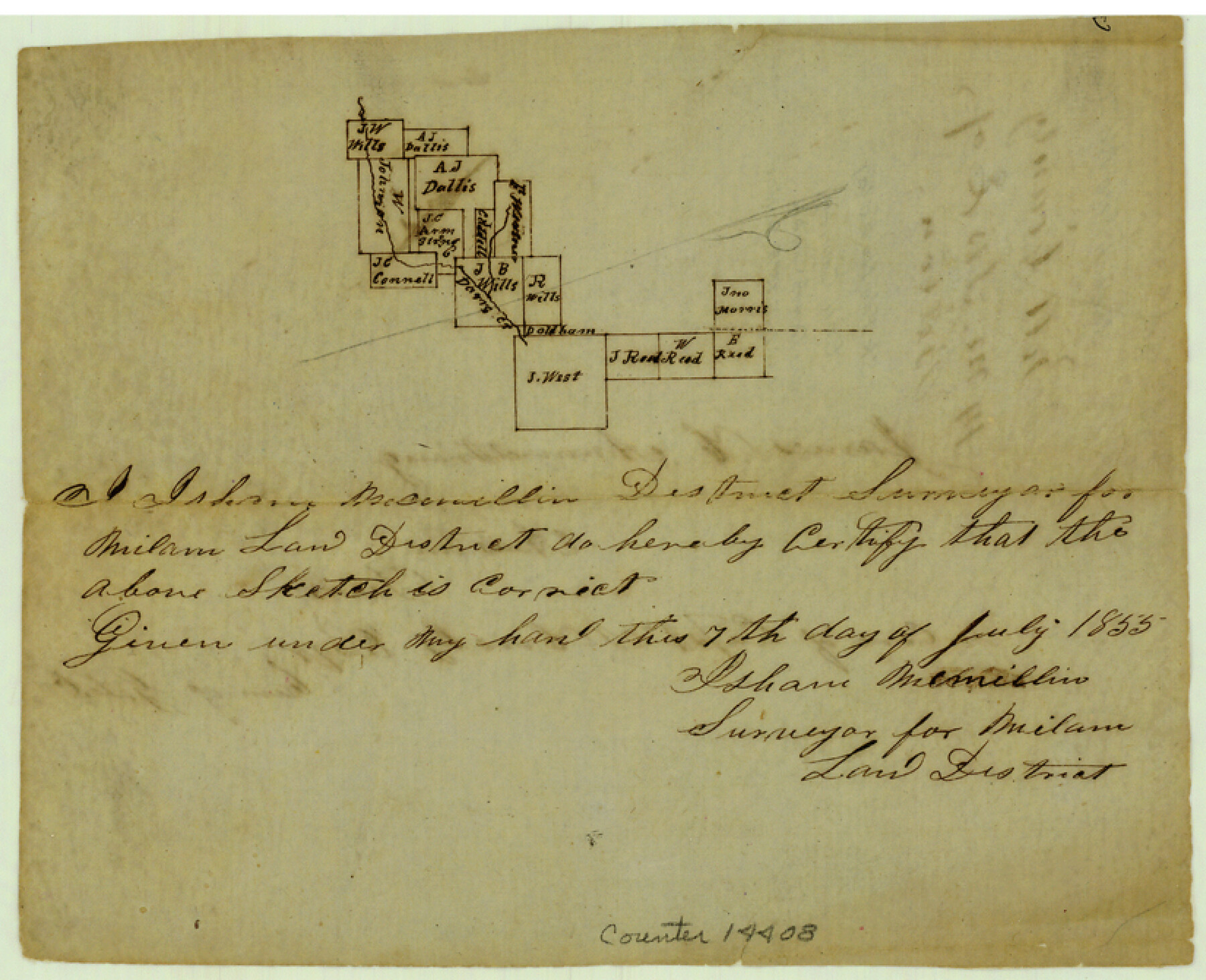
Bell County Sketch File 20a
[Sketch of surveys on Darr's Creek]
-
Map/Doc
14408
-
Collection
General Map Collection
-
Object Dates
1855/7/7 (Creation Date)
-
People and Organizations
Isham McMillin (Surveyor/Engineer)
-
Counties
Bell
-
Subjects
Surveying Sketch File
-
Height x Width
6.7 x 8.3 inches
17.0 x 21.1 cm
-
Medium
paper, manuscript
-
Features
Darr's Creek
Part of: General Map Collection
Bosque County Sketch File 7

Print $4.00
- Digital $50.00
Bosque County Sketch File 7
1852
Size 12.7 x 7.7 inches
Map/Doc 14750
Nueces County Sketch File 26

Print $40.00
- Digital $50.00
Nueces County Sketch File 26
1890
Size 26.7 x 23.2 inches
Map/Doc 42184
Hardin County

Print $20.00
- Digital $50.00
Hardin County
1940
Size 47.4 x 42.4 inches
Map/Doc 73171
[Overlay for Fractional Township No. 7 South Range No. 17 East of the Indian Meridian, Indian Territory]
![75230, [Overlay for Fractional Township No. 7 South Range No. 17 East of the Indian Meridian, Indian Territory], General Map Collection](https://historictexasmaps.com/wmedia_w700/maps/75230.tif.jpg)
Print $3.00
- Digital $50.00
[Overlay for Fractional Township No. 7 South Range No. 17 East of the Indian Meridian, Indian Territory]
Size 11.2 x 11.7 inches
Map/Doc 75230
Map of Silverton, County Seat of Briscoe County, Texas

Print $20.00
- Digital $50.00
Map of Silverton, County Seat of Briscoe County, Texas
1891
Size 24.3 x 19.8 inches
Map/Doc 4832
Caldwell County Working Sketch 4

Print $20.00
- Digital $50.00
Caldwell County Working Sketch 4
1922
Size 46.1 x 43.5 inches
Map/Doc 67834
Newton County Sketch File 13

Print $22.00
- Digital $50.00
Newton County Sketch File 13
Size 8.1 x 12.7 inches
Map/Doc 32386
McMullen County Working Sketch 24

Print $20.00
- Digital $50.00
McMullen County Working Sketch 24
1950
Size 31.5 x 31.0 inches
Map/Doc 70725
Reagan County Working Sketch 46a

Print $20.00
- Digital $50.00
Reagan County Working Sketch 46a
1970
Size 34.5 x 30.4 inches
Map/Doc 71888
Bailey County Working Sketch 3

Print $20.00
- Digital $50.00
Bailey County Working Sketch 3
1922
Size 17.3 x 28.0 inches
Map/Doc 67590
Panola County Working Sketch 17

Print $40.00
- Digital $50.00
Panola County Working Sketch 17
1945
Map/Doc 71426
Armstrong County

Print $20.00
- Digital $50.00
Armstrong County
1933
Size 39.3 x 39.4 inches
Map/Doc 77203
You may also like
Culberson County Rolled Sketch 38A

Print $20.00
- Digital $50.00
Culberson County Rolled Sketch 38A
Size 27.2 x 30.0 inches
Map/Doc 5662
Starr County Sketch File 5

Print $40.00
- Digital $50.00
Starr County Sketch File 5
Size 31.4 x 40.7 inches
Map/Doc 82571
Territory of New Mexico

Print $20.00
- Digital $50.00
Territory of New Mexico
1896
Size 43.4 x 36.5 inches
Map/Doc 76177

Brewster County Sketch File NS-8

Print $311.00
- Digital $50.00
Brewster County Sketch File NS-8
Size 15.0 x 9.1 inches
Map/Doc 15999
Duval County Sketch File 75

Print $20.00
- Digital $50.00
Duval County Sketch File 75
1935
Size 18.0 x 28.5 inches
Map/Doc 11409
Brazoria County NRC Article 33.136 Sketch 31

Print $24.00
Brazoria County NRC Article 33.136 Sketch 31
2025
Map/Doc 97476
Leon County Sketch File 38

Print $10.00
- Digital $50.00
Leon County Sketch File 38
1999
Size 11.0 x 8.5 inches
Map/Doc 29878
Palo Pinto County Sketch File 28

Print $8.00
- Digital $50.00
Palo Pinto County Sketch File 28
1875
Size 11.3 x 8.6 inches
Map/Doc 33437
Ownership Map NE 1/4 Lubbock County [and attached letter]
![93025, Ownership Map NE 1/4 Lubbock County [and attached letter], Twichell Survey Records](https://historictexasmaps.com/wmedia_w700/maps/93025-1.tif.jpg)
Print $20.00
- Digital $50.00
Ownership Map NE 1/4 Lubbock County [and attached letter]
Size 36.3 x 39.3 inches
Map/Doc 93025
Nolan County Sketch File 11

Print $20.00
- Digital $50.00
Nolan County Sketch File 11
1902
Size 18.5 x 37.5 inches
Map/Doc 42162
Hutchinson County Rolled Sketch 21

Print $20.00
- Digital $50.00
Hutchinson County Rolled Sketch 21
Size 28.4 x 36.1 inches
Map/Doc 6286