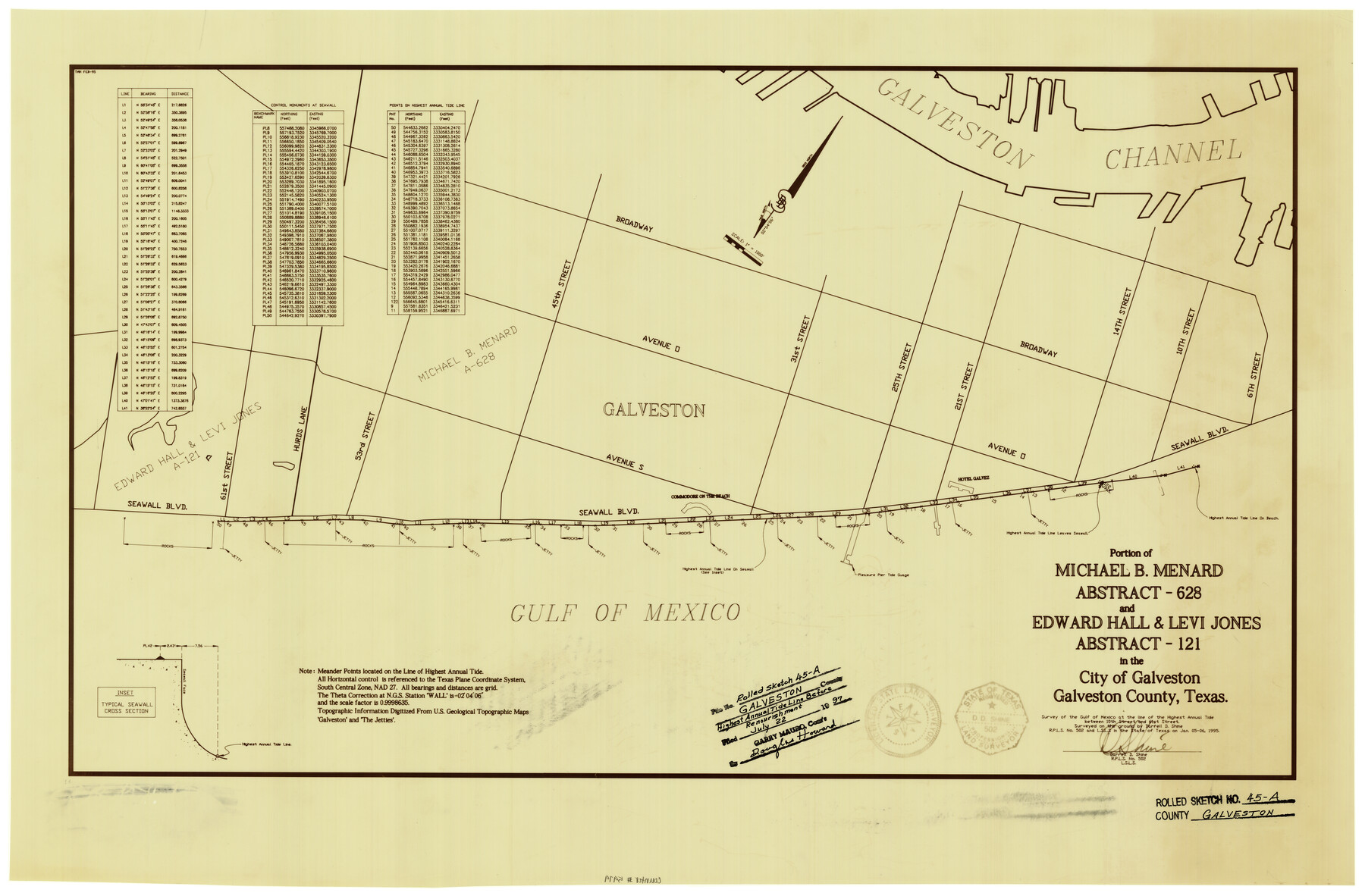
Galveston County Rolled Sketch 45A
Portion of Michael B. Menard abstract-628 and Edward Hall & Levi Jones abstract-121 in the City of Galveston
-
Map/Doc
5979
-
Collection
General Map Collection
-
Object Dates
1/6/1995 (Creation Date)
7/22/1997 (File Date)
-
People and Organizations
Darrell D. Shine (Surveyor/Engineer)
-
Counties
Galveston
-
Subjects
Surveying Rolled Sketch
-
Height x Width
19.6 x 29.9 inches
49.8 x 76.0 cm
-
Medium
mylar, print
-
Scale
1" = 1000 feet
-
Comments
Survey of the Gulf of Mexico at the line of the Highest Annual Tide between 10th Street and 61st Street
Part of: General Map Collection
Gillespie County Working Sketch 14

Print $20.00
- Digital $50.00
Gillespie County Working Sketch 14
2011
Size 36.6 x 36.6 inches
Map/Doc 90096
Harris County Sketch File G

Print $4.00
- Digital $50.00
Harris County Sketch File G
1860
Size 6.6 x 7.3 inches
Map/Doc 25319
Edwards County Working Sketch 83

Print $20.00
- Digital $50.00
Edwards County Working Sketch 83
1965
Size 29.2 x 34.3 inches
Map/Doc 68959
Rockwall County Boundary File 9a

Print $4.00
- Digital $50.00
Rockwall County Boundary File 9a
Size 14.0 x 8.8 inches
Map/Doc 58437
Parker County Boundary File 1

Print $6.00
- Digital $50.00
Parker County Boundary File 1
Size 11.2 x 8.7 inches
Map/Doc 57833
Galveston County Sketch File 73

Print $78.00
- Digital $50.00
Galveston County Sketch File 73
1998
Size 11.3 x 8.8 inches
Map/Doc 23980
Montague County Sketch File 8

Print $22.00
- Digital $50.00
Montague County Sketch File 8
Size 8.1 x 3.7 inches
Map/Doc 31722
Webb County Sketch File 66

Print $20.00
- Digital $50.00
Webb County Sketch File 66
1950
Size 13.4 x 20.6 inches
Map/Doc 12655
Upshur County Rolled Sketch 2

Print $20.00
- Digital $50.00
Upshur County Rolled Sketch 2
1954
Size 26.8 x 23.4 inches
Map/Doc 8061
Ellis County Sketch File 18

Print $40.00
- Digital $50.00
Ellis County Sketch File 18
Size 16.0 x 12.8 inches
Map/Doc 21862
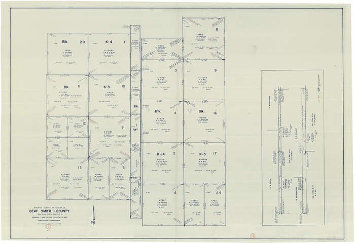
Deaf Smith County Working Sketch 5
Print $40.00
- Digital $50.00
Deaf Smith County Working Sketch 5
1983
Size 37.0 x 53.9 inches
Map/Doc 68645
Southern Part of Laguna Madre

Print $20.00
- Digital $50.00
Southern Part of Laguna Madre
1952
Size 44.7 x 35.2 inches
Map/Doc 73537
You may also like
Limestone County Sketch File 19

Print $4.00
- Digital $50.00
Limestone County Sketch File 19
1922
Size 11.0 x 8.7 inches
Map/Doc 30193
Yellowhouse Addition to Littlefield, Texas Located on Labors 12 & 13 Capitol League 664

Print $20.00
- Digital $50.00
Yellowhouse Addition to Littlefield, Texas Located on Labors 12 & 13 Capitol League 664
1925
Size 26.9 x 26.7 inches
Map/Doc 92402
King County Working Sketch 1

Print $20.00
- Digital $50.00
King County Working Sketch 1
1913
Size 18.2 x 23.8 inches
Map/Doc 70165
Flight Mission No. DIX-6P, Frame 192, Aransas County

Print $20.00
- Digital $50.00
Flight Mission No. DIX-6P, Frame 192, Aransas County
1956
Size 19.0 x 22.8 inches
Map/Doc 83854
Jefferson County Sketch File 48

Print $20.00
- Digital $50.00
Jefferson County Sketch File 48
1875
Size 19.8 x 21.0 inches
Map/Doc 11882
Preliminary Chart of Entrance to Brazos River, Texas

Print $20.00
- Digital $50.00
Preliminary Chart of Entrance to Brazos River, Texas
1858
Size 18.4 x 19.5 inches
Map/Doc 69973
Anderson County Working Sketch 12

Print $20.00
- Digital $50.00
Anderson County Working Sketch 12
1914
Size 15.1 x 12.4 inches
Map/Doc 67012
Blanco County Sketch File 21b

Print $40.00
- Digital $50.00
Blanco County Sketch File 21b
1882
Size 16.9 x 17.8 inches
Map/Doc 10930
EL&RR S2, HE&WT K3, Pt.L&SV K, C4 & C3

Print $20.00
- Digital $50.00
EL&RR S2, HE&WT K3, Pt.L&SV K, C4 & C3
Size 23.3 x 17.5 inches
Map/Doc 90416
Outer Continental Shelf Leasing Maps (Louisiana Offshore Operations)

Print $20.00
- Digital $50.00
Outer Continental Shelf Leasing Maps (Louisiana Offshore Operations)
1959
Size 17.7 x 13.9 inches
Map/Doc 76114

Trinity River, Emhouse Sheet/Chambers Creek

Print $6.00
- Digital $50.00
Trinity River, Emhouse Sheet/Chambers Creek
1931
Size 35.3 x 34.8 inches
Map/Doc 65232