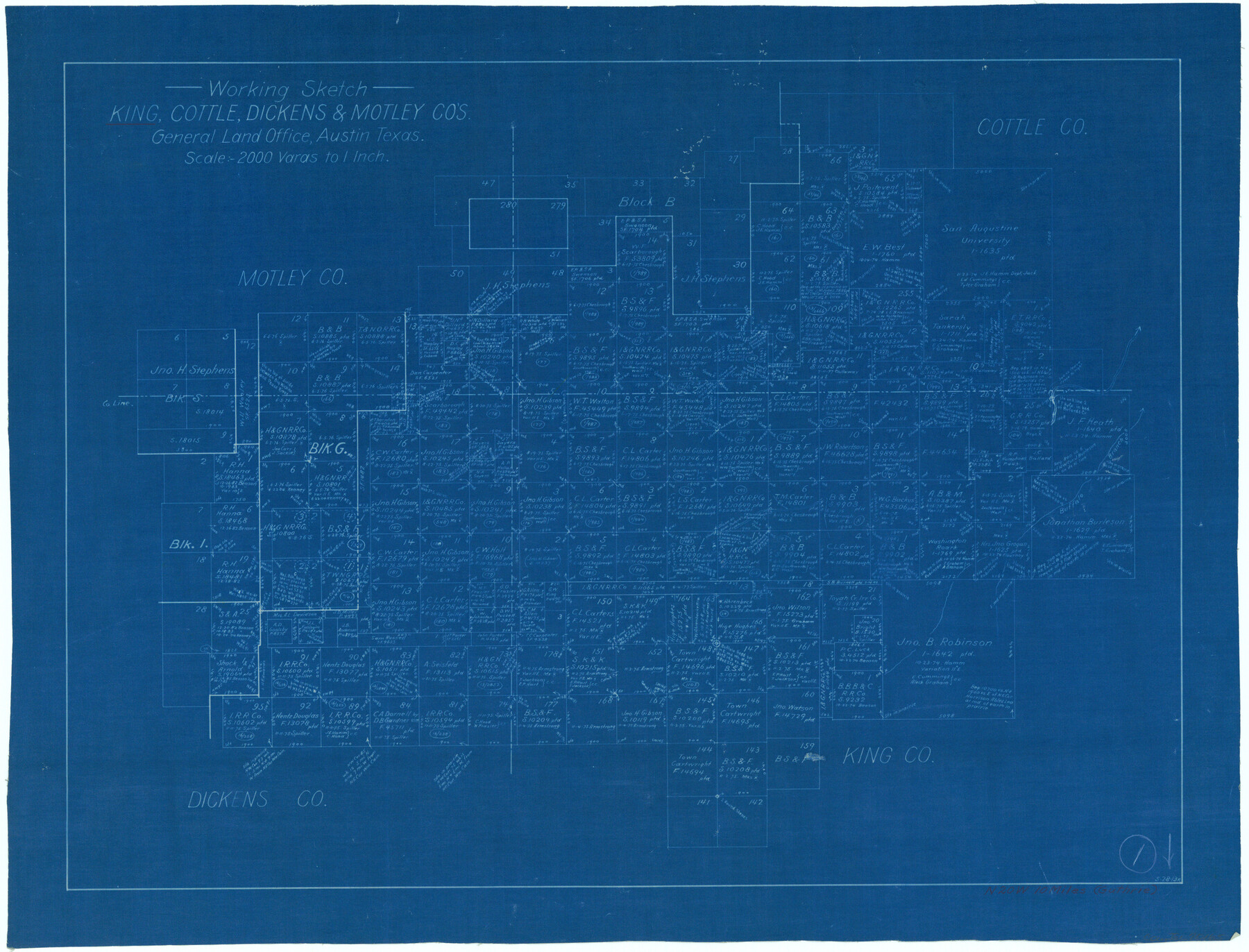
King County Working Sketch 1
-
Map/Doc
70165
-
Collection
General Map Collection
-
Object Dates
5/28/1913 (Creation Date)
-
Counties
King Cottle Dickens Motley
-
Subjects
Surveying Working Sketch
-
Height x Width
18.2 x 23.8 inches
46.2 x 60.5 cm
-
Scale
1" = 2000 varas
Part of: General Map Collection
Gillespie County Boundary File 3a

Print $20.00
- Digital $50.00
Gillespie County Boundary File 3a
Size 24.6 x 37.6 inches
Map/Doc 53753
Robertson County Working Sketch 10

Print $20.00
- Digital $50.00
Robertson County Working Sketch 10
1984
Size 20.1 x 21.6 inches
Map/Doc 63583
Starr County Sketch File 30A

Print $20.00
- Digital $50.00
Starr County Sketch File 30A
1935
Size 21.2 x 23.6 inches
Map/Doc 12334
Lynn County Rolled Sketch 12

Print $20.00
- Digital $50.00
Lynn County Rolled Sketch 12
1956
Size 35.0 x 24.5 inches
Map/Doc 6648
Montgomery County Working Sketch 54

Print $20.00
- Digital $50.00
Montgomery County Working Sketch 54
1961
Size 30.6 x 28.3 inches
Map/Doc 71161
Angelina County Sketch File 14

Print $2.00
- Digital $50.00
Angelina County Sketch File 14
Size 7.6 x 6.9 inches
Map/Doc 12959
Brewster County Rolled Sketch 153

Print $20.00
- Digital $50.00
Brewster County Rolled Sketch 153
Size 32.4 x 19.2 inches
Map/Doc 5320
Potter County Boundary File 6

Print $24.00
- Digital $50.00
Potter County Boundary File 6
Size 14.8 x 9.2 inches
Map/Doc 58027
Webb County Rolled Sketch 13

Print $20.00
- Digital $50.00
Webb County Rolled Sketch 13
Size 17.6 x 33.8 inches
Map/Doc 8177
Gillespie County

Print $40.00
- Digital $50.00
Gillespie County
1887
Size 34.6 x 49.8 inches
Map/Doc 66836
San Patricio County Rolled Sketch 48

Print $20.00
- Digital $50.00
San Patricio County Rolled Sketch 48
1984
Size 42.5 x 26.8 inches
Map/Doc 9903

You may also like
General Highway Map Llano County Texas

Print $20.00
- Digital $50.00
General Highway Map Llano County Texas
1953
Size 17.1 x 12.5 inches
Map/Doc 92883
The Republic County of Fort Bend. December 29, 1845

Print $20.00
The Republic County of Fort Bend. December 29, 1845
2020
Size 14.7 x 21.6 inches
Map/Doc 96142

Lynn County Rolled Sketch A

Print $20.00
- Digital $50.00
Lynn County Rolled Sketch A
1901
Size 33.5 x 34.2 inches
Map/Doc 9471
Northern Part of Laguna Madre

Print $20.00
- Digital $50.00
Northern Part of Laguna Madre
1972
Size 44.2 x 35.0 inches
Map/Doc 73529
Cochran County Working Sketch 5

Print $20.00
- Digital $50.00
Cochran County Working Sketch 5
Size 23.8 x 24.9 inches
Map/Doc 68016
Location of the Southern Kansas Railway of Texas, Carson County, Texas

Print $40.00
- Digital $50.00
Location of the Southern Kansas Railway of Texas, Carson County, Texas
1887
Size 20.5 x 84.3 inches
Map/Doc 64035
General Highway Map, Falls County, Texas

Print $20.00
General Highway Map, Falls County, Texas
1961
Size 18.2 x 24.5 inches
Map/Doc 79462
Zapata County Working Sketch 24

Print $20.00
- Digital $50.00
Zapata County Working Sketch 24
1992
Size 28.2 x 23.9 inches
Map/Doc 62075
[Sketch showing School Lands]
![90286, [Sketch showing School Lands], Twichell Survey Records](https://historictexasmaps.com/wmedia_w700/maps/90286-1.tif.jpg)
Print $20.00
- Digital $50.00
[Sketch showing School Lands]
Size 24.1 x 18.1 inches
Map/Doc 90286
Map of the country in the vicinity of San Antonio de Bexar reduced in part from the county map of Bexar with additions by J. Edmd. Blake, 1st Lieut Topl. Engs.

Print $20.00
- Digital $50.00
Map of the country in the vicinity of San Antonio de Bexar reduced in part from the county map of Bexar with additions by J. Edmd. Blake, 1st Lieut Topl. Engs.
1845
Size 18.3 x 26.1 inches
Map/Doc 72720
Brazos River, Brazos River Sheet 3

Print $6.00
- Digital $50.00
Brazos River, Brazos River Sheet 3
1926
Size 23.6 x 35.2 inches
Map/Doc 65295