Limestone County Sketch File 19
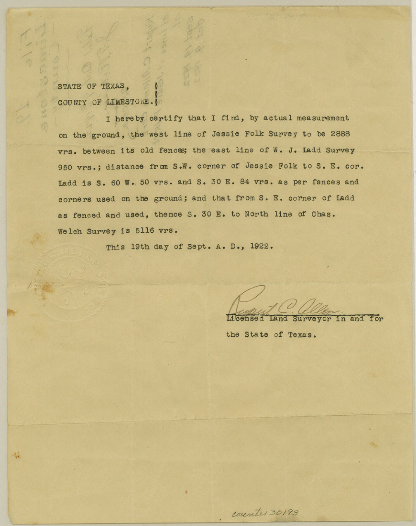
[Certificate regarding west line of Jessie Folk survey]
-
Map/Doc
30193
-
Collection
General Map Collection
-
Object Dates
9/19/1922 (Creation Date)
10/9/1922 (File Date)
-
People and Organizations
Robert C. Allen (Surveyor/Engineer)
-
Counties
Limestone
-
Subjects
Surveying Sketch File
-
Height x Width
11.0 x 8.7 inches
27.9 x 22.1 cm
-
Medium
paper, print
Part of: General Map Collection
Travis County Appraisal District Plat Map 2_0801

Print $20.00
- Digital $50.00
Travis County Appraisal District Plat Map 2_0801
Size 21.4 x 26.4 inches
Map/Doc 94237
Webb County Sketch File 44b

Print $8.00
- Digital $50.00
Webb County Sketch File 44b
1936
Size 14.5 x 9.0 inches
Map/Doc 39829
McLennan County Boundary File 7

Print $8.00
- Digital $50.00
McLennan County Boundary File 7
Size 14.1 x 8.6 inches
Map/Doc 57005
Upton County Rolled Sketch 33

Print $20.00
- Digital $50.00
Upton County Rolled Sketch 33
1951
Size 39.2 x 33.0 inches
Map/Doc 8076
Dawson County Sketch File 31

Print $4.00
- Digital $50.00
Dawson County Sketch File 31
1989
Size 11.4 x 9.0 inches
Map/Doc 20614
Flight Mission No. CGI-2N, Frame 153, Cameron County

Print $20.00
- Digital $50.00
Flight Mission No. CGI-2N, Frame 153, Cameron County
1954
Size 18.8 x 22.3 inches
Map/Doc 84535
Midland County

Print $20.00
- Digital $50.00
Midland County
1901
Size 43.7 x 40.3 inches
Map/Doc 66929
Calhoun County Rolled Sketch 7

Print $20.00
- Digital $50.00
Calhoun County Rolled Sketch 7
Size 17.0 x 22.1 inches
Map/Doc 5363
Chambers County Sketch File 47

Print $211.00
- Digital $50.00
Chambers County Sketch File 47
1927
Size 14.3 x 9.0 inches
Map/Doc 17899
Randall County Boundary File 5

Print $14.00
- Digital $50.00
Randall County Boundary File 5
Size 8.9 x 7.8 inches
Map/Doc 58134
Sketch for Mineral Application 33721 - 33725 Incl (Attorney General) - Map of Padre Island - Cameron, Willacy, Kleberg, Nueces and Kenedy Counties.

Print $20.00
- Digital $50.00
Sketch for Mineral Application 33721 - 33725 Incl (Attorney General) - Map of Padre Island - Cameron, Willacy, Kleberg, Nueces and Kenedy Counties.
Size 43.3 x 23.1 inches
Map/Doc 65663
Freestone County Working Sketch 31

Print $20.00
- Digital $50.00
Freestone County Working Sketch 31
1995
Size 42.8 x 33.9 inches
Map/Doc 78205
You may also like

Terrell County Working Sketch 74

Print $20.00
- Digital $50.00
Terrell County Working Sketch 74
1981
Size 37.5 x 24.6 inches
Map/Doc 69595
Hardin County Sketch File 68

Print $20.00
- Digital $50.00
Hardin County Sketch File 68
1948
Size 23.9 x 21.4 inches
Map/Doc 11640
Events of the Texas Revolution

Events of the Texas Revolution
2023
Size 11.0 x 17.0 inches
Map/Doc 97194
Map of Denton County

Print $20.00
- Digital $50.00
Map of Denton County
1896
Size 25.6 x 22.0 inches
Map/Doc 11311
Sutton County Working Sketch 42

Print $20.00
- Digital $50.00
Sutton County Working Sketch 42
1950
Size 34.5 x 29.1 inches
Map/Doc 62385
Panola County Rolled Sketch 6

Print $40.00
- Digital $50.00
Panola County Rolled Sketch 6
1956
Size 26.0 x 55.7 inches
Map/Doc 9679
Upton County Working Sketch 49B

Print $20.00
- Digital $50.00
Upton County Working Sketch 49B
1979
Size 19.0 x 32.0 inches
Map/Doc 69546
Hudspeth County Sketch File 11

Print $14.00
- Digital $50.00
Hudspeth County Sketch File 11
Size 14.5 x 8.9 inches
Map/Doc 26903
El Paso County Rolled Sketch 65

Print $20.00
- Digital $50.00
El Paso County Rolled Sketch 65
2012
Size 24.5 x 36.8 inches
Map/Doc 93327

Map of SW portion of Hale Co., Texas

Print $3.00
- Digital $50.00
Map of SW portion of Hale Co., Texas
Size 12.7 x 10.8 inches
Map/Doc 518