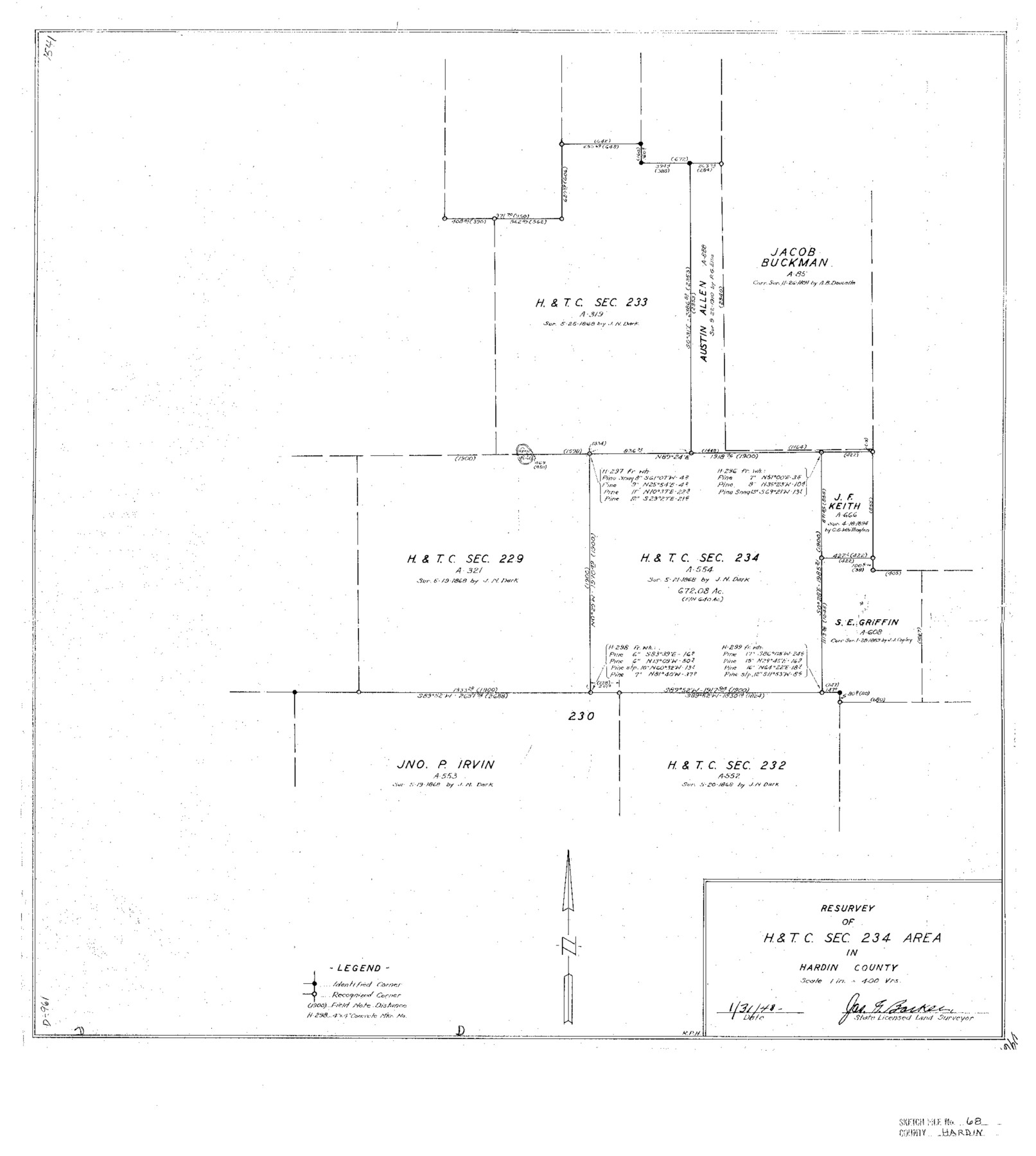
Hardin County Sketch File 68
Resurvey of H.&T.C. Sec. 234 Area in Hardin County
-
Map/Doc
11640
-
Collection
General Map Collection
-
Object Dates
1948/1/31 (Creation Date)
-
People and Organizations
James G. Barker (Surveyor/Engineer)
-
Counties
Hardin
-
Subjects
Surveying Sketch File
-
Height x Width
23.9 x 21.4 inches
60.7 x 54.4 cm
-
Medium
paper, print
-
Scale
1:400
Part of: General Map Collection
[San Antonio & Aransas Pass]
![64211, [San Antonio & Aransas Pass], General Map Collection](https://historictexasmaps.com/wmedia_w700/maps/64211.tif.jpg)
Print $2.00
- Digital $50.00
[San Antonio & Aransas Pass]
Size 11.6 x 8.2 inches
Map/Doc 64211
Briscoe County Sketch File 8

Print $6.00
- Digital $50.00
Briscoe County Sketch File 8
1896
Size 10.5 x 8.3 inches
Map/Doc 16417
Baylor County Aerial Photograph Index Sheet 1

Print $20.00
- Digital $50.00
Baylor County Aerial Photograph Index Sheet 1
1950
Size 21.4 x 17.4 inches
Map/Doc 83663
[Surveys along the Sabine River made under G.W. Smyth, Commissioner]
![89, [Surveys along the Sabine River made under G.W. Smyth, Commissioner], General Map Collection](https://historictexasmaps.com/wmedia_w700/maps/89.tif.jpg)
Print $20.00
- Digital $50.00
[Surveys along the Sabine River made under G.W. Smyth, Commissioner]
Size 12.6 x 17.1 inches
Map/Doc 89
Flight Mission No. CGI-4N, Frame 180, Cameron County

Print $20.00
- Digital $50.00
Flight Mission No. CGI-4N, Frame 180, Cameron County
1955
Size 18.5 x 22.3 inches
Map/Doc 84683
Navigation Maps of Gulf Intracoastal Waterway, Port Arthur to Brownsville, Texas

Print $4.00
- Digital $50.00
Navigation Maps of Gulf Intracoastal Waterway, Port Arthur to Brownsville, Texas
1951
Size 16.6 x 21.4 inches
Map/Doc 65448
Morris County Boundary File 1

Print $18.00
- Digital $50.00
Morris County Boundary File 1
Size 14.1 x 8.7 inches
Map/Doc 57473
Flight Mission No. DAG-21K, Frame 121, Matagorda County

Print $20.00
- Digital $50.00
Flight Mission No. DAG-21K, Frame 121, Matagorda County
1952
Size 18.6 x 22.3 inches
Map/Doc 86447
Culberson County Working Sketch 78

Print $40.00
- Digital $50.00
Culberson County Working Sketch 78
1976
Size 51.8 x 36.2 inches
Map/Doc 68532
Hardin County Sketch File 29

Print $4.00
- Digital $50.00
Hardin County Sketch File 29
Size 8.1 x 11.8 inches
Map/Doc 25155
Pecos County Sketch File 106

Print $6.00
- Digital $50.00
Pecos County Sketch File 106
1967
Size 14.2 x 8.8 inches
Map/Doc 34030
Yoakum County Rolled Sketch 7

Print $20.00
- Digital $50.00
Yoakum County Rolled Sketch 7
2012
Size 25.9 x 18.7 inches
Map/Doc 93291
You may also like
Randall County Sketch File 1

Print $50.00
- Digital $50.00
Randall County Sketch File 1
1912
Size 24.6 x 35.6 inches
Map/Doc 12205
[Sketch of Elizabeth Stanley and Wm. Rivers surveys]
![91984, [Sketch of Elizabeth Stanley and Wm. Rivers surveys], Twichell Survey Records](https://historictexasmaps.com/wmedia_w700/maps/91984-1.tif.jpg)
Print $20.00
- Digital $50.00
[Sketch of Elizabeth Stanley and Wm. Rivers surveys]
Size 23.3 x 10.4 inches
Map/Doc 91984
Brewster County Rolled Sketch 49B

Print $20.00
- Digital $50.00
Brewster County Rolled Sketch 49B
Size 14.2 x 24.2 inches
Map/Doc 5225
Henderson County Rolled Sketch 7

Print $20.00
- Digital $50.00
Henderson County Rolled Sketch 7
1963
Size 22.9 x 41.9 inches
Map/Doc 6203
Flight Mission No. BRE-2P, Frame 15, Nueces County

Print $20.00
- Digital $50.00
Flight Mission No. BRE-2P, Frame 15, Nueces County
1956
Size 18.4 x 22.4 inches
Map/Doc 86724
Wheeler County Working Sketch 7

Print $40.00
- Digital $50.00
Wheeler County Working Sketch 7
1972
Size 50.1 x 42.9 inches
Map/Doc 72496
Crockett County Rolled Sketch 88K

Print $40.00
- Digital $50.00
Crockett County Rolled Sketch 88K
1973
Size 43.0 x 57.4 inches
Map/Doc 8735
Clay County Working Sketch 12

Print $20.00
- Digital $50.00
Clay County Working Sketch 12
1955
Size 30.6 x 39.4 inches
Map/Doc 68035
Burnet County Rolled Sketch 7

Print $20.00
- Digital $50.00
Burnet County Rolled Sketch 7
1987
Size 18.4 x 24.0 inches
Map/Doc 5357

Knox County Rolled Sketch 25

Print $20.00
- Digital $50.00
Knox County Rolled Sketch 25
2007
Size 11.4 x 10.8 inches
Map/Doc 88749
[Sketch showing voting precincts in Jim Hogg and Brooks Counties]
![4497, [Sketch showing voting precincts in Jim Hogg and Brooks Counties], Maddox Collection](https://historictexasmaps.com/wmedia_w700/maps/4497-1.tif.jpg)
Print $20.00
- Digital $50.00
[Sketch showing voting precincts in Jim Hogg and Brooks Counties]
Size 10.1 x 18.2 inches
Map/Doc 4497