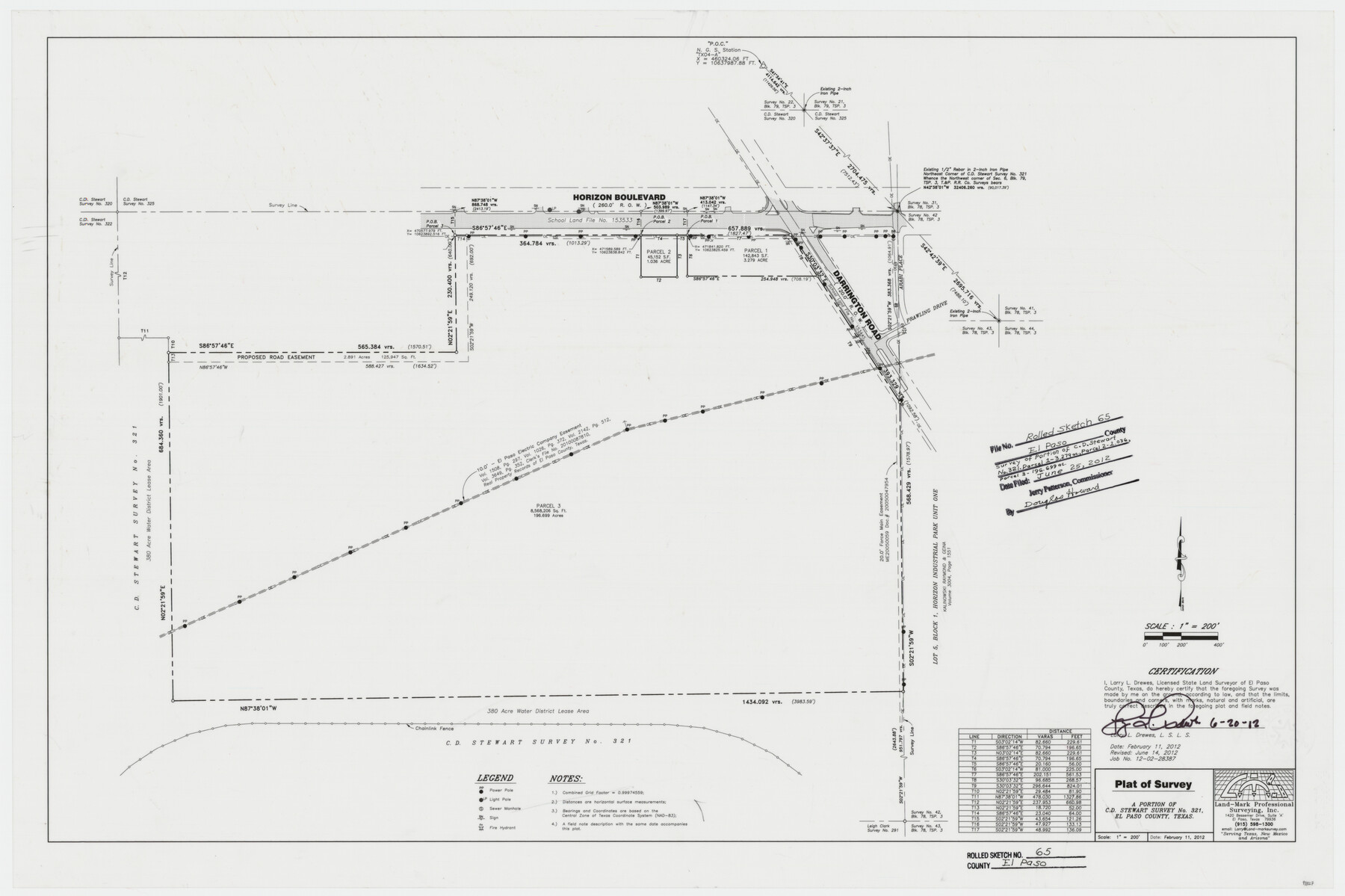
El Paso County Rolled Sketch 65
Plat of survey - a portion of C.D. Stewart survey no. 321, El Paso County, Texas
-
Map/Doc
93327
-
Collection
General Map Collection
-
Object Dates
2012/6/25 (File Date)
2012/2/11 (Creation Date)
2012/6/20 (Revision Date)
-
People and Organizations
Larry L. Drewes (Surveyor/Engineer)
-
Counties
El Paso
-
Subjects
Surveying Rolled Sketch
-
Height x Width
24.5 x 36.8 inches
62.2 x 93.5 cm
-
Medium
mylar, print
-
Scale
1" = 200 feet
Part of: General Map Collection
Bell County Rolled Sketch 1

Print $20.00
- Digital $50.00
Bell County Rolled Sketch 1
1954
Size 38.1 x 41.1 inches
Map/Doc 75938
DeWitt County Sketch File 2

Print $40.00
- Digital $50.00
DeWitt County Sketch File 2
1868
Size 13.0 x 12.2 inches
Map/Doc 20799
Sterling County Rolled Sketch 9

Print $20.00
- Digital $50.00
Sterling County Rolled Sketch 9
1929
Size 29.3 x 24.3 inches
Map/Doc 7845
Parker County Working Sketch 12

Print $20.00
- Digital $50.00
Parker County Working Sketch 12
1974
Map/Doc 71462
Red River County Sketch File 4

Print $6.00
- Digital $50.00
Red River County Sketch File 4
Size 9.3 x 11.5 inches
Map/Doc 35100
Bell County Working Sketch 7

Print $20.00
- Digital $50.00
Bell County Working Sketch 7
1947
Size 43.7 x 34.9 inches
Map/Doc 67347
Montgomery County Working Sketch 8b

Print $20.00
- Digital $50.00
Montgomery County Working Sketch 8b
1932
Size 17.7 x 20.7 inches
Map/Doc 71115
Travis County Sketch File 64

Print $20.00
- Digital $50.00
Travis County Sketch File 64
1949
Size 23.7 x 25.0 inches
Map/Doc 12474
[Sketch showing the Rio Grande with towns and features annotated]
![72895, [Sketch showing the Rio Grande with towns and features annotated], General Map Collection](https://historictexasmaps.com/wmedia_w700/maps/72895.tif.jpg)
Print $20.00
- Digital $50.00
[Sketch showing the Rio Grande with towns and features annotated]
1854
Size 24.4 x 18.3 inches
Map/Doc 72895
Bee County Working Sketch 27

Print $20.00
- Digital $50.00
Bee County Working Sketch 27
1988
Size 27.0 x 23.4 inches
Map/Doc 67277
Moore County Rolled Sketch 3

Print $20.00
- Digital $50.00
Moore County Rolled Sketch 3
Size 12.3 x 15.3 inches
Map/Doc 6823
West Part of Liberty Co.

Print $20.00
- Digital $50.00
West Part of Liberty Co.
1977
Size 46.2 x 35.5 inches
Map/Doc 73220
You may also like
Henderson County Working Sketch 9

Print $20.00
- Digital $50.00
Henderson County Working Sketch 9
1921
Size 30.9 x 16.7 inches
Map/Doc 66142
Pecos County Sketch File 103

Print $46.00
- Digital $50.00
Pecos County Sketch File 103
1963
Size 16.7 x 9.9 inches
Map/Doc 34016
Outer Continental Shelf Leasing Maps (Texas Offshore Operations)

Print $20.00
- Digital $50.00
Outer Continental Shelf Leasing Maps (Texas Offshore Operations)
Size 17.7 x 14.3 inches
Map/Doc 75856
Louisiana and Texas Intracoastal Waterway Proposed Extension to Rio Grande Valley

Print $20.00
- Digital $50.00
Louisiana and Texas Intracoastal Waterway Proposed Extension to Rio Grande Valley
1941
Size 22.0 x 33.0 inches
Map/Doc 61889
San Patricio County Rolled Sketch 46

Print $20.00
- Digital $50.00
San Patricio County Rolled Sketch 46
1983
Size 19.6 x 25.5 inches
Map/Doc 7730
Ownership Map SE 1/4 Lubbock County

Print $20.00
- Digital $50.00
Ownership Map SE 1/4 Lubbock County
Size 36.6 x 35.9 inches
Map/Doc 89898
Matagorda County Aerial Photograph Index Sheet 8

Print $20.00
- Digital $50.00
Matagorda County Aerial Photograph Index Sheet 8
1953
Size 19.6 x 23.8 inches
Map/Doc 83729
Comanche County Sketch File 8

Print $4.00
- Digital $50.00
Comanche County Sketch File 8
1853
Size 13.1 x 8.2 inches
Map/Doc 19066
Nueces County Rolled Sketch 95

Print $20.00
- Digital $50.00
Nueces County Rolled Sketch 95
1983
Size 18.2 x 24.7 inches
Map/Doc 7052

Wilson County Working Sketch 10

Print $20.00
- Digital $50.00
Wilson County Working Sketch 10
1980
Size 16.6 x 11.7 inches
Map/Doc 72590
Flight Mission No. BRA-9M, Frame 63, Jefferson County

Print $20.00
- Digital $50.00
Flight Mission No. BRA-9M, Frame 63, Jefferson County
1953
Size 18.6 x 22.4 inches
Map/Doc 85646