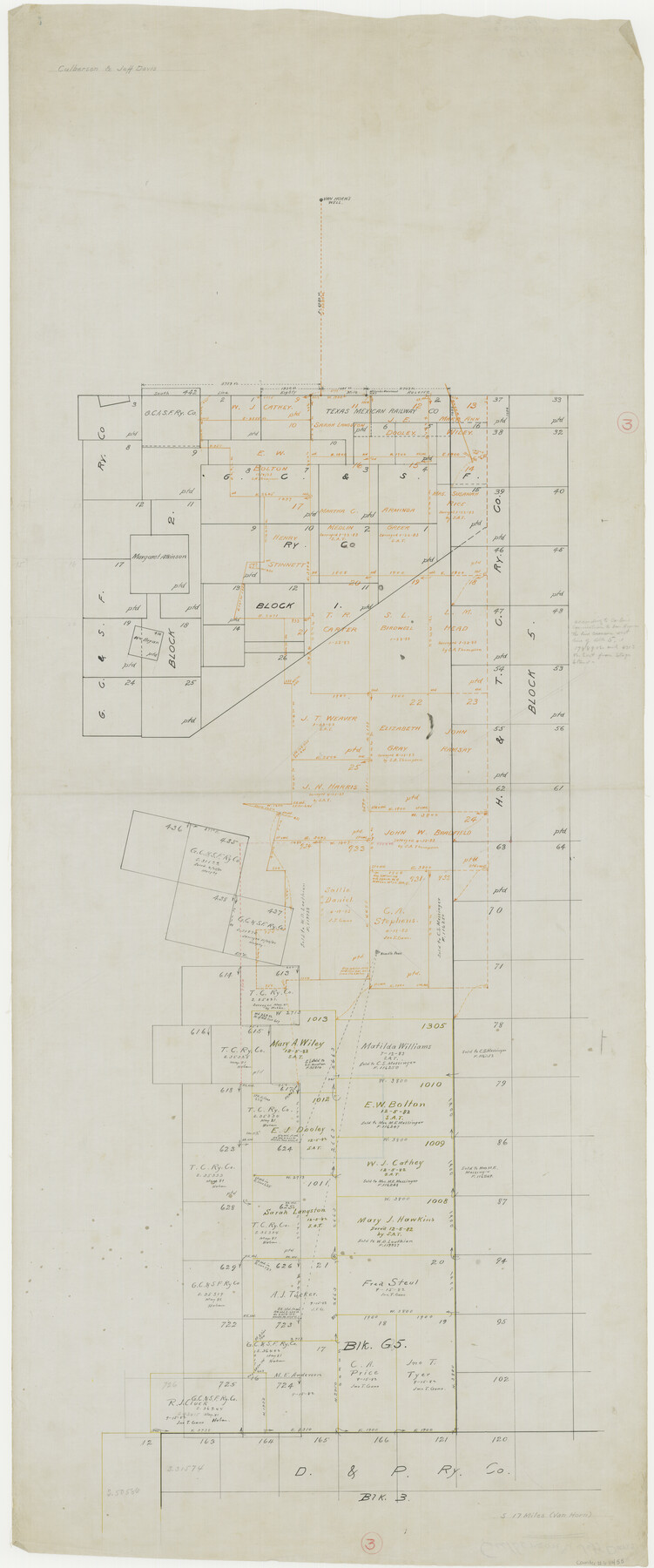
Culberson County Working Sketch 3
-
Map/Doc
68455
-
Collection
General Map Collection
-
Counties
Culberson Jeff Davis
-
Subjects
Surveying Working Sketch
-
Height x Width
50.6 x 21.1 inches
128.5 x 53.6 cm
Part of: General Map Collection
Kinney County Rolled Sketch 1

Print $20.00
- Digital $50.00
Kinney County Rolled Sketch 1
Size 25.1 x 36.1 inches
Map/Doc 6533
Freestone County Sketch File 9

Print $4.00
- Digital $50.00
Freestone County Sketch File 9
1859
Size 7.9 x 8.3 inches
Map/Doc 23056
San Jacinto County Working Sketch 43

Print $20.00
- Digital $50.00
San Jacinto County Working Sketch 43
1981
Size 36.4 x 45.5 inches
Map/Doc 63757
Flight Mission No. DAH-9M, Frame 156, Orange County

Print $20.00
- Digital $50.00
Flight Mission No. DAH-9M, Frame 156, Orange County
1953
Size 18.6 x 22.4 inches
Map/Doc 86855
Presidio County Sketch File G

Print $6.00
- Digital $50.00
Presidio County Sketch File G
1913
Size 9.7 x 17.0 inches
Map/Doc 34429
Dickens County Sketch File 28

Print $23.00
- Digital $50.00
Dickens County Sketch File 28
Size 14.5 x 9.0 inches
Map/Doc 21005
Crockett County Working Sketch 56

Print $20.00
- Digital $50.00
Crockett County Working Sketch 56
1947
Size 28.5 x 46.7 inches
Map/Doc 68389
Lynn County Rolled Sketch 5

Print $20.00
- Digital $50.00
Lynn County Rolled Sketch 5
1912
Size 17.1 x 26.4 inches
Map/Doc 6645
Flight Mission No. CGI-3N, Frame 180, Cameron County

Print $20.00
- Digital $50.00
Flight Mission No. CGI-3N, Frame 180, Cameron County
1954
Size 18.6 x 22.2 inches
Map/Doc 84644

Controlled Mosaic by Jack Amman Photogrammetric Engineers, Inc - Sheet 20

Print $20.00
- Digital $50.00
Controlled Mosaic by Jack Amman Photogrammetric Engineers, Inc - Sheet 20
1954
Size 20.0 x 24.0 inches
Map/Doc 83466
Navarro County Sketch File 4

Print $6.00
- Digital $50.00
Navarro County Sketch File 4
1852
Size 7.5 x 7.2 inches
Map/Doc 32304
You may also like
Ward County Rolled Sketch 22

Print $40.00
- Digital $50.00
Ward County Rolled Sketch 22
1873
Size 69.2 x 18.0 inches
Map/Doc 10110
Jasper County

Print $40.00
- Digital $50.00
Jasper County
1898
Size 65.1 x 37.4 inches
Map/Doc 82048
Crane County Sketch File 18

Print $20.00
- Digital $50.00
Crane County Sketch File 18
1927
Size 15.1 x 18.4 inches
Map/Doc 11210
Jack County Working Sketch 24

Print $20.00
- Digital $50.00
Jack County Working Sketch 24
2010
Size 24.1 x 29.7 inches
Map/Doc 90030
Fractional Township No. 8 South Range No. 1 East of the Indian Meridian, Indian Territory

Print $20.00
- Digital $50.00
Fractional Township No. 8 South Range No. 1 East of the Indian Meridian, Indian Territory
1898
Size 19.3 x 24.3 inches
Map/Doc 75200
W. M. Kuykendall Ranch, Matagorda County, Texas

Print $20.00
- Digital $50.00
W. M. Kuykendall Ranch, Matagorda County, Texas
1926
Size 24.3 x 39.6 inches
Map/Doc 3028
Flight Mission No. CRC-3R, Frame 96, Chambers County

Print $20.00
- Digital $50.00
Flight Mission No. CRC-3R, Frame 96, Chambers County
1956
Size 18.7 x 22.4 inches
Map/Doc 84834
Coleman County Boundary File 17a

Print $84.00
- Digital $50.00
Coleman County Boundary File 17a
Size 17.5 x 17.1 inches
Map/Doc 51663
Duval County Working Sketch 45

Print $20.00
- Digital $50.00
Duval County Working Sketch 45
1979
Size 29.7 x 30.8 inches
Map/Doc 68769
Falls County Sketch File 11b

Print $4.00
- Digital $50.00
Falls County Sketch File 11b
1871
Size 10.4 x 8.5 inches
Map/Doc 22362
Pecos County Rolled Sketch 22

Print $40.00
- Digital $50.00
Pecos County Rolled Sketch 22
1886
Size 73.4 x 45.2 inches
Map/Doc 93461
Winkler County Working Sketch 8

Print $20.00
- Digital $50.00
Winkler County Working Sketch 8
1958
Size 31.9 x 30.7 inches
Map/Doc 72602