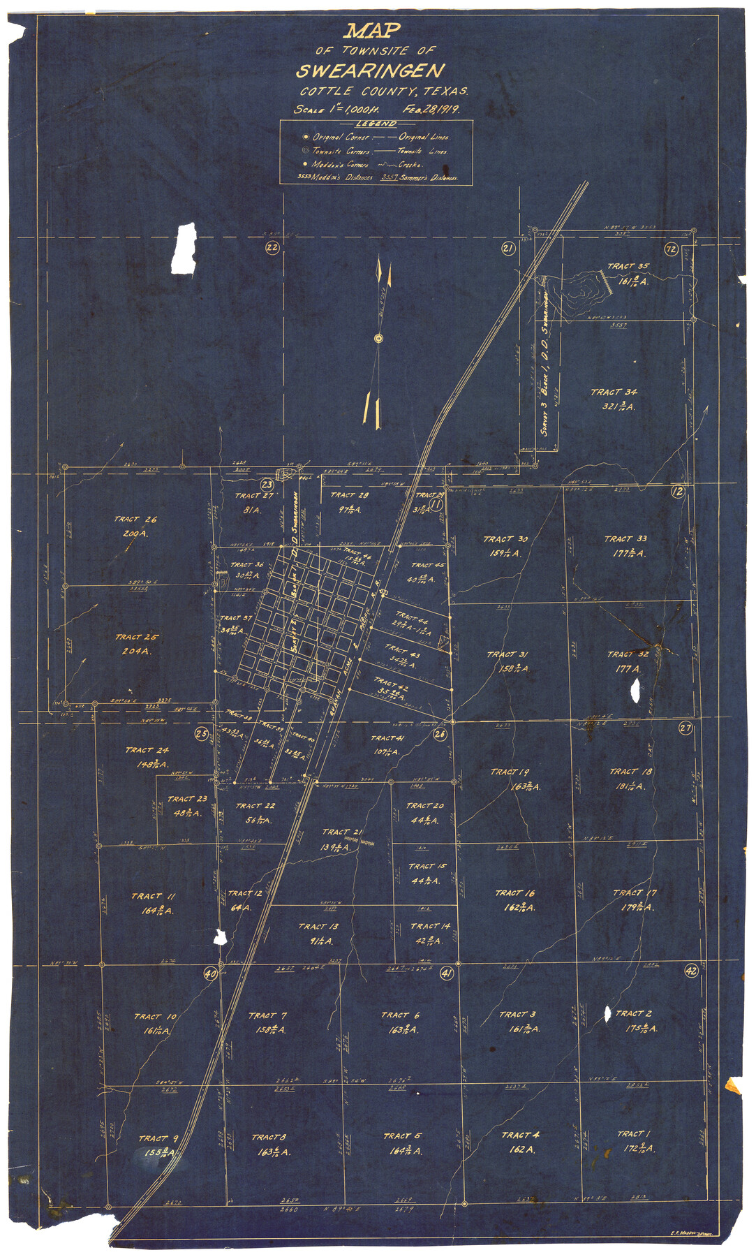
Map of Townsite of Swearingen, Cottle County, Texas
-
Map/Doc
4463
-
Collection
Maddox Collection
-
Object Dates
2/28/1919 (Creation Date)
-
People and Organizations
E.F. Maddox (Draftsman)
-
Counties
Cottle
-
Subjects
City
-
Height x Width
28.1 x 17.1 inches
71.4 x 43.4 cm
-
Medium
blueprint/diazo
-
Scale
1" = 1000 ft
-
Comments
Counter 89101 is blueprint copy of this map.
-
Features
Cat Fish Creek
QA&P
John Jones Street
Sam White Street
Ledbetter Street
Koch Street
Hagelstein Street
Swearengin
Decker Street
Quanah Street
Margaret Street
Lucille Street
Paducah Street
Brewer Street
Part of: Maddox Collection
Map of Anderson County, Texas

Print $20.00
- Digital $50.00
Map of Anderson County, Texas
1879
Size 18.5 x 21.7 inches
Map/Doc 377
Subdivision for R.N. Graham

Print $3.00
- Digital $50.00
Subdivision for R.N. Graham
1913
Size 10.4 x 15.2 inches
Map/Doc 473
[Santa Rosa Leagues, Brooks & Kenedy Counties, Texas]
![10774, [Santa Rosa Leagues, Brooks & Kenedy Counties, Texas], Maddox Collection](https://historictexasmaps.com/wmedia_w700/maps/10774.tif.jpg)
Print $20.00
- Digital $50.00
[Santa Rosa Leagues, Brooks & Kenedy Counties, Texas]
Size 21.0 x 24.6 inches
Map/Doc 10774
Map showing surveys in Blocks 45, 3, R & 5T

Print $20.00
- Digital $50.00
Map showing surveys in Blocks 45, 3, R & 5T
1913
Size 30.2 x 37.5 inches
Map/Doc 496
Skeleton Map of Nueces County

Print $20.00
- Digital $50.00
Skeleton Map of Nueces County
1907
Size 32.4 x 37.3 inches
Map/Doc 593
Map of Hays County, Texas

Print $20.00
- Digital $50.00
Map of Hays County, Texas
1880
Size 24.3 x 21.4 inches
Map/Doc 5029
Hansford County, Texas

Print $20.00
- Digital $50.00
Hansford County, Texas
1880
Size 19.9 x 18.9 inches
Map/Doc 528
Callahan County, Texas

Print $20.00
- Digital $50.00
Callahan County, Texas
1880
Size 24.1 x 18.5 inches
Map/Doc 89276
Map of Kimble County, Texas

Print $20.00
- Digital $50.00
Map of Kimble County, Texas
1879
Size 18.1 x 28.3 inches
Map/Doc 527
Motley County, Texas

Print $20.00
- Digital $50.00
Motley County, Texas
1883
Size 23.6 x 20.7 inches
Map/Doc 743
Map of West Part of Galveston County, Texas

Print $20.00
- Digital $50.00
Map of West Part of Galveston County, Texas
1880
Size 28.6 x 21.9 inches
Map/Doc 716
Graham's Addition Being a Subdivision of a Portion of Lot No. 1 of Spear League

Print $20.00
- Digital $50.00
Graham's Addition Being a Subdivision of a Portion of Lot No. 1 of Spear League
1914
Size 33.2 x 13.6 inches
Map/Doc 83426
You may also like
Mason County Working Sketch 3

Print $20.00
- Digital $50.00
Mason County Working Sketch 3
1911
Size 17.8 x 22.9 inches
Map/Doc 70839
Liberty County Sketch File 46

Print $42.00
- Digital $50.00
Liberty County Sketch File 46
1860
Size 13.4 x 12.2 inches
Map/Doc 30005
Mme. Begue and her Recipes - Old Creole Cookery

Mme. Begue and her Recipes - Old Creole Cookery
1900
Size 5.9 x 3.9 inches
Map/Doc 96607
[Sketch Showing L. Gonzales, Wm. H. McBee and adjacent surveys, Kaufman County, Texas]
![5071, [Sketch Showing L. Gonzales, Wm. H. McBee and adjacent surveys, Kaufman County, Texas], Maddox Collection](https://historictexasmaps.com/wmedia_w700/maps/5071.tif.jpg)
Print $20.00
- Digital $50.00
[Sketch Showing L. Gonzales, Wm. H. McBee and adjacent surveys, Kaufman County, Texas]
Size 23.2 x 19.8 inches
Map/Doc 5071
Red River County Working Sketch 81-1

Print $20.00
- Digital $50.00
Red River County Working Sketch 81-1
1987
Size 14.6 x 18.4 inches
Map/Doc 72064
McLennan County Boundary File 1a

Print $14.00
- Digital $50.00
McLennan County Boundary File 1a
Size 8.0 x 6.6 inches
Map/Doc 56941
Clay County Sketch File 40

Print $12.00
- Digital $50.00
Clay County Sketch File 40
Size 11.3 x 8.5 inches
Map/Doc 18476
[Surveys in the Montgomery District: San Jacinto River and Caney Creek, Navidad, Navasota]
![69744, [Surveys in the Montgomery District: San Jacinto River and Caney Creek, Navidad, Navasota], General Map Collection](https://historictexasmaps.com/wmedia_w700/maps/69744.tif.jpg)
Print $2.00
- Digital $50.00
[Surveys in the Montgomery District: San Jacinto River and Caney Creek, Navidad, Navasota]
Size 5.1 x 7.3 inches
Map/Doc 69744
Kimble County Working Sketch 50

Print $20.00
- Digital $50.00
Kimble County Working Sketch 50
1952
Size 34.8 x 22.1 inches
Map/Doc 70118
[Northwest Part of GLO Crockett County Map]
![91569, [Northwest Part of GLO Crockett County Map], Twichell Survey Records](https://historictexasmaps.com/wmedia_w700/maps/91569-1.tif.jpg)
Print $20.00
- Digital $50.00
[Northwest Part of GLO Crockett County Map]
Size 14.0 x 19.1 inches
Map/Doc 91569
San Jacinto County Working Sketch 16

Print $20.00
- Digital $50.00
San Jacinto County Working Sketch 16
1934
Size 35.7 x 42.2 inches
Map/Doc 63729
Conoco Official Road Map New Mexico

Print $20.00
- Digital $50.00
Conoco Official Road Map New Mexico
1934
Size 18.5 x 24.4 inches
Map/Doc 92436