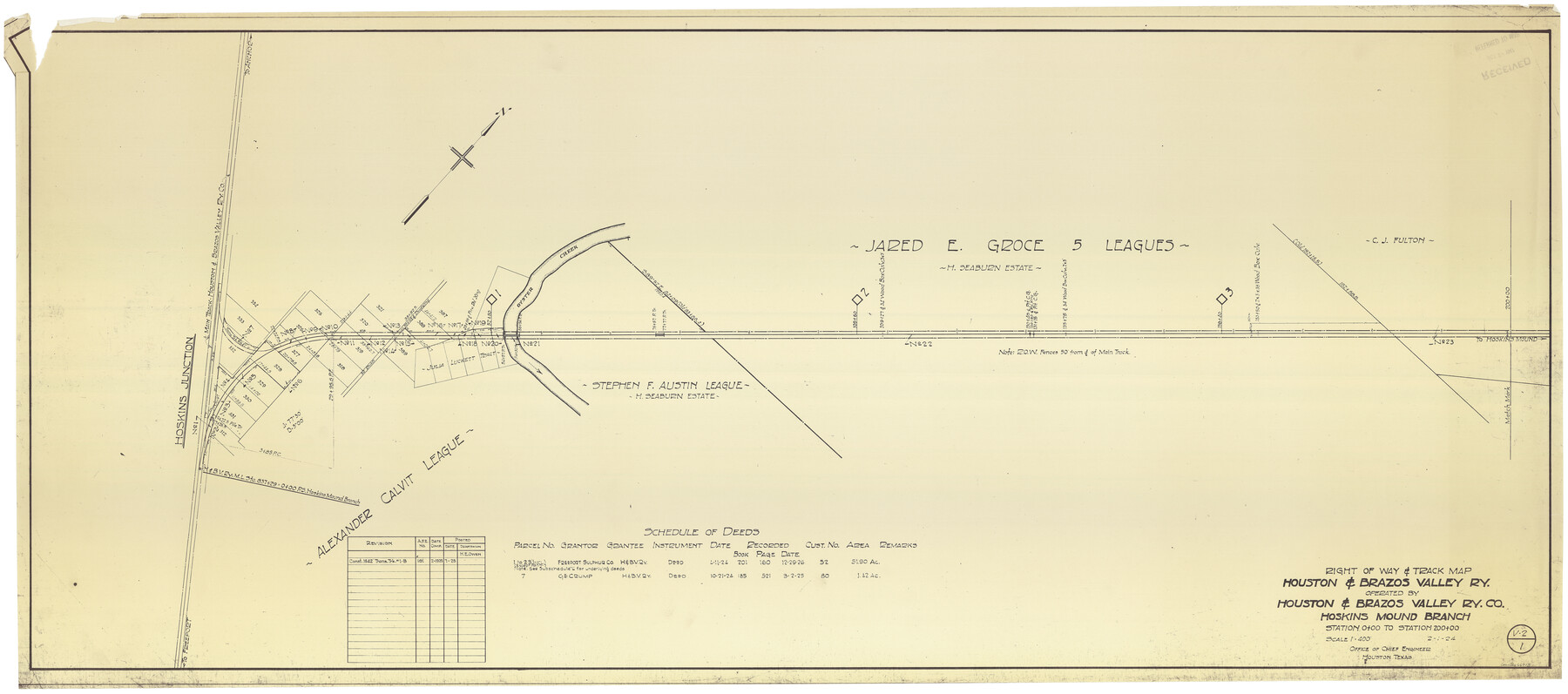
Right of Way & Track Map Houston & Brazos Valley Ry. operated by Houston & Brazos Valley Ry. Co., Hoskins Mound Branch
Station 0+00 to Station 200+00
Z-2-185
-
Map/Doc
66713
-
Collection
General Map Collection
-
Object Dates
2/12/1924 (Creation Date)
-
Counties
Brazoria
-
Subjects
Railroads
-
Height x Width
25.0 x 56.7 inches
63.5 x 144.0 cm
-
Medium
blueprint/diazo
-
Scale
1" = 400 feet
-
Comments
See counter nos. 64602 through 64611 for other sheets.
-
Features
H&BV
[Railroad line] to Hoskins Mound
Oyster Creek
[Railroad line] to Anchor
Hoskins Junction
[Railroad line] to Freeport
Part of: General Map Collection
Reeves County Rolled Sketch 30

Print $20.00
- Digital $50.00
Reeves County Rolled Sketch 30
1988
Size 18.4 x 24.4 inches
Map/Doc 7499
Cottle County Sketch File 6b

Print $2.00
- Digital $50.00
Cottle County Sketch File 6b
Size 8.8 x 14.1 inches
Map/Doc 19477
Brewster County Working Sketch 64

Print $20.00
- Digital $50.00
Brewster County Working Sketch 64
1957
Size 31.8 x 29.3 inches
Map/Doc 67665
Flight Mission No. DAH-17M, Frame 26, Orange County

Print $20.00
- Digital $50.00
Flight Mission No. DAH-17M, Frame 26, Orange County
1953
Size 18.3 x 22.3 inches
Map/Doc 86889
Harris County Sketch File AA-1

Print $20.00
- Digital $50.00
Harris County Sketch File AA-1
Size 19.0 x 26.1 inches
Map/Doc 11646
Flight Mission No. BRA-8M, Frame 114, Jefferson County

Print $20.00
- Digital $50.00
Flight Mission No. BRA-8M, Frame 114, Jefferson County
1953
Size 18.6 x 22.2 inches
Map/Doc 85610
Flight Mission No. DQN-2K, Frame 31, Calhoun County

Print $20.00
- Digital $50.00
Flight Mission No. DQN-2K, Frame 31, Calhoun County
1953
Size 18.7 x 22.3 inches
Map/Doc 84238
Crockett County Rolled Sketch 48

Print $20.00
- Digital $50.00
Crockett County Rolled Sketch 48
1939
Size 30.0 x 40.3 inches
Map/Doc 8712
Real County Working Sketch 76

Print $20.00
- Digital $50.00
Real County Working Sketch 76
1979
Size 30.6 x 21.1 inches
Map/Doc 71968


Index for Texas Railroad ROW & track maps available on microfilm at THD & Archives and Records

Print $2.00
- Digital $50.00
Index for Texas Railroad ROW & track maps available on microfilm at THD & Archives and Records
1977
Size 11.2 x 8.8 inches
Map/Doc 60756
You may also like
El Paso County Boundary File 5

Print $80.00
- Digital $50.00
El Paso County Boundary File 5
Size 34.7 x 48.4 inches
Map/Doc 53078
Hutchinson County Rolled Sketch 43

Print $40.00
- Digital $50.00
Hutchinson County Rolled Sketch 43
1992
Size 40.6 x 49.9 inches
Map/Doc 6315
[Surveys in Austin's Colony along New Year's Creek]
![204, [Surveys in Austin's Colony along New Year's Creek], General Map Collection](https://historictexasmaps.com/wmedia_w700/maps/204.tif.jpg)
Print $20.00
- Digital $50.00
[Surveys in Austin's Colony along New Year's Creek]
1828
Size 12.9 x 15.5 inches
Map/Doc 204
Travis County Working Sketch 49

Print $20.00
- Digital $50.00
Travis County Working Sketch 49
1984
Size 33.9 x 37.2 inches
Map/Doc 69433
[E. L. & R. R. RR. Blk. 32 and Blk.10 in Northwest corner of County]
![90124, [E. L. & R. R. RR. Blk. 32 and Blk.10 in Northwest corner of County], Twichell Survey Records](https://historictexasmaps.com/wmedia_w700/maps/90124-1.tif.jpg)
Print $2.00
- Digital $50.00
[E. L. & R. R. RR. Blk. 32 and Blk.10 in Northwest corner of County]
Size 14.2 x 8.7 inches
Map/Doc 90124
Presidio County Rolled Sketch 141

Print $20.00
- Digital $50.00
Presidio County Rolled Sketch 141
Size 40.8 x 28.6 inches
Map/Doc 89064
Hall County Sketch File 36

Print $4.00
- Digital $50.00
Hall County Sketch File 36
1914
Size 11.2 x 8.8 inches
Map/Doc 24895
Culberson County Rolled Sketch 19A
Print $20.00
- Digital $50.00
Culberson County Rolled Sketch 19A
Size 23.2 x 28.6 inches
Map/Doc 5652
Calcasieu Pass to Sabine Pass

Print $20.00
- Digital $50.00
Calcasieu Pass to Sabine Pass
1992
Size 44.5 x 35.8 inches
Map/Doc 69815
Matagorda County Sketch File 16

Print $4.00
- Digital $50.00
Matagorda County Sketch File 16
Size 8.4 x 10.3 inches
Map/Doc 30780
Guadalupe County Sketch File 25

Print $22.00
- Digital $50.00
Guadalupe County Sketch File 25
Size 12.7 x 15.7 inches
Map/Doc 24717
Boundary Between the United States & Mexico Agreed upon by the Joint Commission under the Treaty of Guadalupe Hidalgo

Print $20.00
- Digital $50.00
Boundary Between the United States & Mexico Agreed upon by the Joint Commission under the Treaty of Guadalupe Hidalgo
1853
Size 18.3 x 26.7 inches
Map/Doc 72885