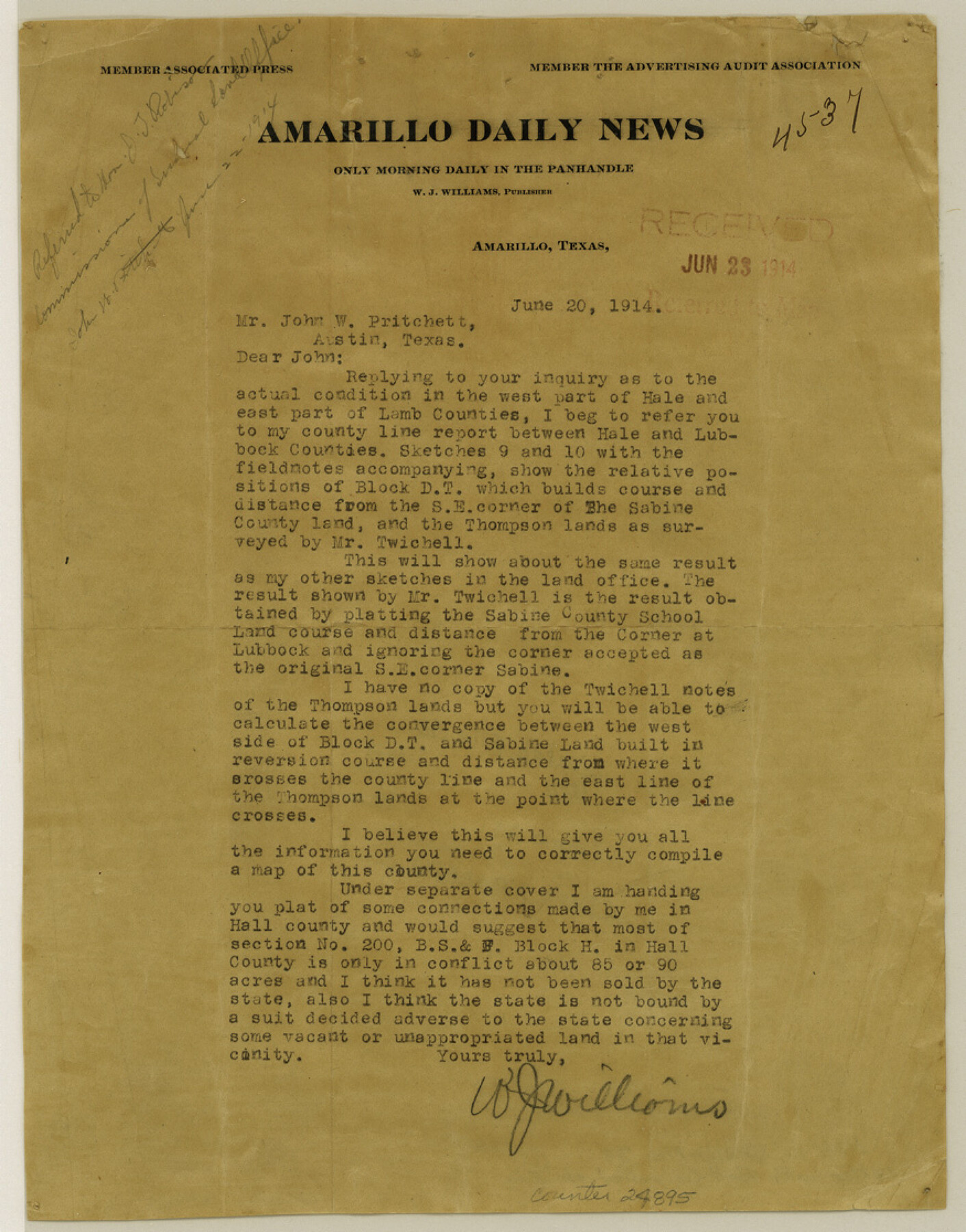
Hall County Sketch File 36
[Letter from W. J. Williams to John W. Pritchett]
-
Map/Doc
24895
-
Collection
General Map Collection
-
Object Dates
1914/6/20 (Creation Date)
1914/6/23 (File Date)
-
People and Organizations
W.Jeff Williams (Surveyor/Engineer)
W.D. Twichell (Surveyor/Engineer)
-
Counties
Hall Lamb Hale Lubbock
-
Subjects
Surveying Sketch File
-
Height x Width
11.2 x 8.8 inches
28.4 x 22.4 cm
-
Medium
paper, print
Part of: General Map Collection
Hudspeth County Working Sketch 35

Print $40.00
- Digital $50.00
Hudspeth County Working Sketch 35
Size 37.0 x 55.2 inches
Map/Doc 66320
Kaufman County Working Sketch 5

Print $20.00
- Digital $50.00
Kaufman County Working Sketch 5
1922
Size 31.8 x 46.0 inches
Map/Doc 66668
Ochiltree County

Print $20.00
- Digital $50.00
Ochiltree County
1958
Size 41.0 x 33.1 inches
Map/Doc 77386
Shelby County

Print $20.00
- Digital $50.00
Shelby County
1945
Size 41.5 x 46.1 inches
Map/Doc 63034
Brazoria County Working Sketch 30

Print $20.00
- Digital $50.00
Brazoria County Working Sketch 30
1974
Size 37.5 x 43.8 inches
Map/Doc 67515
Walker County Working Sketch 6

Print $20.00
- Digital $50.00
Walker County Working Sketch 6
1935
Size 30.8 x 40.6 inches
Map/Doc 72286
Amistad International Reservoir on Rio Grande 82

Print $20.00
- Digital $50.00
Amistad International Reservoir on Rio Grande 82
1949
Size 28.5 x 40.2 inches
Map/Doc 75511
Gulf Coast of the United States, Key West to Rio Grande

Print $20.00
- Digital $50.00
Gulf Coast of the United States, Key West to Rio Grande
1863
Size 27.3 x 18.2 inches
Map/Doc 72663
Howard County

Print $20.00
- Digital $50.00
Howard County
1922
Size 40.3 x 34.6 inches
Map/Doc 77318
Motley County Sketch File 34 (S)

Print $20.00
- Digital $50.00
Motley County Sketch File 34 (S)
1951
Size 26.5 x 13.6 inches
Map/Doc 42149
Crockett County Rolled Sketch 37

Print $20.00
- Digital $50.00
Crockett County Rolled Sketch 37
Size 36.7 x 29.3 inches
Map/Doc 5589
Wheeler County Working Sketch 12

Print $40.00
- Digital $50.00
Wheeler County Working Sketch 12
1978
Size 38.5 x 51.1 inches
Map/Doc 72501
You may also like
Presidio County Rolled Sketch 65

Print $20.00
- Digital $50.00
Presidio County Rolled Sketch 65
Size 23.1 x 28.3 inches
Map/Doc 7356
The Chief Justice County of Liberty. April 25, 1837

Print $20.00
The Chief Justice County of Liberty. April 25, 1837
2020
Size 20.5 x 21.7 inches
Map/Doc 96055
Liberty County Working Sketch 65

Print $20.00
- Digital $50.00
Liberty County Working Sketch 65
1970
Size 27.6 x 47.3 inches
Map/Doc 70525
Cottle County Sketch File 11

Print $40.00
- Digital $50.00
Cottle County Sketch File 11
Size 12.9 x 13.3 inches
Map/Doc 19489
Location of the Kansas City Shreveport & Gulf Railroad, Beaumont to Mayersburg

Print $20.00
- Digital $50.00
Location of the Kansas City Shreveport & Gulf Railroad, Beaumont to Mayersburg
1896
Size 26.0 x 36.5 inches
Map/Doc 64771
Wise County Sketch File 11

Print $4.00
- Digital $50.00
Wise County Sketch File 11
1860
Size 12.8 x 8.0 inches
Map/Doc 40544
Jim Wells County Working Sketch 10

Print $20.00
- Digital $50.00
Jim Wells County Working Sketch 10
1952
Size 18.7 x 17.8 inches
Map/Doc 66608

Armstrong County Boundary File 4

Print $2.00
- Digital $50.00
Armstrong County Boundary File 4
Size 10.2 x 8.8 inches
Map/Doc 50148
Swisher County Sketch File 8

Print $20.00
- Digital $50.00
Swisher County Sketch File 8
1907
Size 19.2 x 16.3 inches
Map/Doc 12405
Reeves County Working Sketch 52
Print $40.00
- Digital $50.00
Reeves County Working Sketch 52
1977
Size 60.3 x 41.9 inches
Map/Doc 63495
Map of Parts of Dawson and Borden Counties

Print $20.00
- Digital $50.00
Map of Parts of Dawson and Borden Counties
Size 23.0 x 17.7 inches
Map/Doc 90627